Table of Contents
- 1. Overview
- 2. Geography and Route Structure of the Dinaric Alps
- 3. History and Culture: Seven Countries, One Spine
- 4. Best Time for Hiking the Via Dinarica
- 5. Which Are the Best Sections of the Via Dinarica?
- 6. Food and Drink Along the Via Dinarica: Eating Your Way Through the Balkans
- 7. Accommodation Options for Hiking the Via Dinarica
- 8. Planning and Logistics: What to Know Before You Go
- 9. Frequently Asked Questions About Hiking the Via Dinarica
Overview
Europe has no shortage of long-distance trails. But hiking the Via Dinarica is something different. This is not a manicured walk through tidy Alpine meadows. It is a 1,200 km (745 mi) route through the Dinaric Alps, a mountain range that runs like a spine down the western Balkans, crossing seven countries, dozens of national parks, and centuries of layered history. For serious trekkers who want to go somewhere that still feels genuinely remote, the Via Dinarica is one of the most compelling trails on the continent.
The trail is actually a network of three routes. The White Trail is the main event: a high-alpine spine that threads through Slovenia, Croatia, Bosnia and Herzegovina, Montenegro, and Albania, following the highest ridgelines of the Dinaric Alps. The Blue Trail hugs the Adriatic coastline through Croatia and Montenegro, offering a maritime counterpoint to the inland wilderness. The Green Trail meanders through the forested valleys and river lowlands in between. All three carry the Via Dinarica name, but the White Trail is the one that defines the route, and the one that most thru-hikers are talking about when they say they want to go hiking in the Via Dinarica.
The project was formally launched in 2010 as an initiative in sustainable adventure tourism, a way to reconnect communities across borders that had been fractured by the wars of the 1990s. The trail links existing shepherd paths, military routes, and national park tracks into a single transnational corridor. In that sense, hiking the Via Dinarica is also an act of peace-building, even if you never think of it that way while navigating a scree field in Montenegro.
What makes this trail unusual, and worth the extra planning effort, is its sheer diversity. In one week you can pass from the karst limestone caves of Slovenia to the wind-scoured ridgelines of the Croatian Velebit, then down into the dense mountain forests of Bosnia. The cultures, cuisines, languages, and landscapes change with every border crossing. It is less a trail than a cultural corridor, and that is both its greatest appeal and its defining challenge.
One thing to set expectations on: the Via Dinarica is not the GR20 or the Tour du Mont Blanc. Infrastructure is uneven. Waymarking is inconsistent across countries. Some sections of the White Trail are excellent, with well-spaced huts and clear markings. The Croatian Velebit is a standout. Others are remote, overgrown, or require GPS navigation to follow reliably. This is a trail that rewards preparation and punishes assumptions. It is also, for the right hiker, an extraordinarily rewarding journey.
DREAMING OF HIKING THE VIA DINARICA ?
Explore our amazing hiking tours in Via Dinarica now!
Geography and Route Structure of the Dinaric Alps
The Dinaric Alps are among Europe's least-known mountain ranges, and among its most dramatic. The range stretches roughly 650 km (404 mi) from the Julian Alps in Slovenia to the Sharr Mountains straddling Kosovo and Albania, a continuous arc of karst limestone, deep canyons, glacial lakes, and alpine plateaus that drops sharply toward the Adriatic in the west and softens into forested hills to the east.
Karst terrain is the defining geological feature of the region. The Dinaric Alps are built almost entirely from limestone that has been dissolved and sculpted by water over millions of years, producing a landscape of sinkholes, cave systems, underground rivers, and barren rock plateaus called poljes. The caves near Postojna in Slovenia, the official start of the White Trail, represent this geology at its most spectacular. So do the bone-white peaks of the Velebit range in Croatia, where the bora wind howls in from the Adriatic with enough force to knock an unprepared hiker sideways.
The three Via Dinarica trails reflect this geographic diversity. The White Trail stays high, often above 1,500 m (4,921 ft), and reaching over 2,500 m (8,202 ft) in Montenegro's Durmitor National Park, where Bobotov Kuk tops out at 2,523 m (8,278 ft). It passes through or near Triglav National Park in Slovenia, Paklenica and Northern Velebit National Parks in Croatia, the Prenj and Cvrsnica massifs of Herzegovina, Sutjeska and Durmitor National Parks in Montenegro, and the Prokletije massif that straddles the Albania-Kosovo-Montenegro tri-border. This is the high alpine backbone.
The Blue Trail, by contrast, never ventures far from sea level. It follows the Dalmatian coast through Croatia and the Bay of Kotor in Montenegro, a completely different world of stone villages, pine forests, and turquoise water. The elevation gain that defines the White Trail is replaced here by coastal path-finding and ferry crossings. The Green Trail, still more of a concept than a completed route, offers a middle ground: valley hiking through forests, villages, and river corridors that lack the high-mountain drama but offer deeper community encounters.
Wildlife across the Dinaric Alps is exceptional and largely undisturbed. Brown bears, gray wolves, and Eurasian lynx all inhabit the forests. Chamois pick across the high ridgelines. Golden eagles circle above the limestone plateaus. The Tara River canyon in Montenegro, at 1,300 m (4,265 ft) the second deepest canyon in the world after the Grand Canyon, supports some of the most pristine river ecosystem in Europe.
History and Culture: Seven Countries, One Spine
The routes that now form the Via Dinarica were not invented by a trail committee. They were worn into the landscape by centuries of necessity: shepherd paths between seasonal pastures, trade routes connecting mountain communities, military tracks used by Ottoman, Austro-Hungarian, and later Yugoslav armies. What the Via Dinarica project did, beginning in 2010, was string these existing threads into a single narrative and give the whole thing a name and a GPS track.
The pastoral tradition of the katun, the seasonal mountain settlements where shepherds bring their herds in summer, shapes the culture of the trail through Bosnia and Montenegro in particular. These are not tourist reconstructions. In many places they are still functioning: small stone huts or wooden structures clustered on high plateaus, inhabited from June to September by families who have been returning for generations. Stopping at a katun for cheese, rakija, and an hour of broken-language conversation is one of the defining experiences of hiking in the Via Dinarica in this region.
The religious diversity of the trail corridor reflects centuries of overlapping influence. Orthodox churches and Muslim tekkes stand within sight of each other in the valleys below the Bosnian highlands. Catholic villages in Croatia give way to Eastern Orthodox communities in Montenegro. Medieval tombstones called stecak, mysterious and monumental, often found in isolated meadows, are UNESCO-listed relics of a Bosnian Church that existed centuries before the Ottoman conquest. Encountering them on a remote hillside, with no signage and no crowds, is one of the quieter surprises of this route.
The scars of the 1990s Yugoslav Wars are present too, particularly in Bosnia. Some trails pass through areas that were mined during the conflict. The BH Mine Suspected Areas app is an essential tool for hiking in Bosnia and Herzegovina, and hikers should stick to marked paths and exercise caution in less-travelled sections. The Via Dinarica organization takes trail safety seriously, and most of the established White Trail route in Bosnia has been cleared and marked, but awareness matters.
Perhaps the most meaningful cultural dimension of hiking the Via Dinarica is the hospitality. Mountain communities across the Balkans share a deep tradition of welcome toward travelers. Guests are fed. Coffee is produced before the conversation begins. Strangers offer their homes for the night. In the most remote sections of Bosnia and Montenegro, where there are no huts and no guesthouses, this tradition is often the thing that makes a thru-hike possible.
Best Time for Hiking the Via Dinarica
The primary hiking window runs from late May to early October, with the peak season concentrated in July and August. Outside of this window, the high-alpine sections are buried under significant snowpack, mountain huts are closed, and some border crossings become impassable on foot. Planning around the seasons is not optional on this trail. It is foundational.
Late Spring: May and June
Late May brings the first viable conditions for high-alpine hiking, though snow remains on the highest passes in both the Velebit and Durmitor sections well into June. Wildflowers are at their most intense, and the days are long. Temperatures on the ridgelines are cool and manageable. The trails are quiet. The downside is unpredictability: June can bring prolonged rain, and any high section above 2,000 m (6,562 ft) should be treated with mountaineering caution. For the Croatian Blue Trail along the coast, late spring is arguably the best time of all, before the summer tourist flood.
Summer: July and August
July and August are the peak months for Via Dinarica hiking. Mountain huts are fully staffed, trail conditions are as good as they get, and the high passes are reliably snow-free. The tradeoff is heat. At lower elevations, in Croatia's Dalmatian hinterland and in the approach valleys of Bosnia, temperatures regularly exceed 35°C (95°F). Hikers who start early and rest in the afternoon hours manage this well. The alpine sections above 1,500 m (4,921 ft) are a different story: warm days, cold nights, and some of the most luminous mountain light in Europe. August in Durmitor or the Prokletije is about as good as mountain hiking gets anywhere.
Early Autumn: September and Early October
September is a favorite month among experienced Via Dinarica hikers, and the reasoning is sound. The summer crowds have thinned, the light has turned golden, temperatures are stable and moderate at all elevations, and the trail conditions are excellent. The forests of Bosnia and Serbia begin to turn in mid-September, adding a visual dimension that the summer months lack. Huts are still open but less pressed for space. There is a sense of the trail returning to itself. Hiking continues into early October in good years, though snowfall can return to the highest sections of the White Trail from late September onward.
Winter: Not Recommended for Most Hikers
Winter conditions on the Via Dinarica White Trail are severe. The high sections of Durmitor, the Prokletije, and the Velebit are genuine mountaineering terrain from November through April, requiring ice axes, crampons, and avalanche awareness. Mountain huts close. Some border crossings become inaccessible. The Blue Trail along the coast is hikeable year-round in mild winters, and the lower Green Trail sections may be accessible, but the White Trail is firmly off-limits without specialist experience.
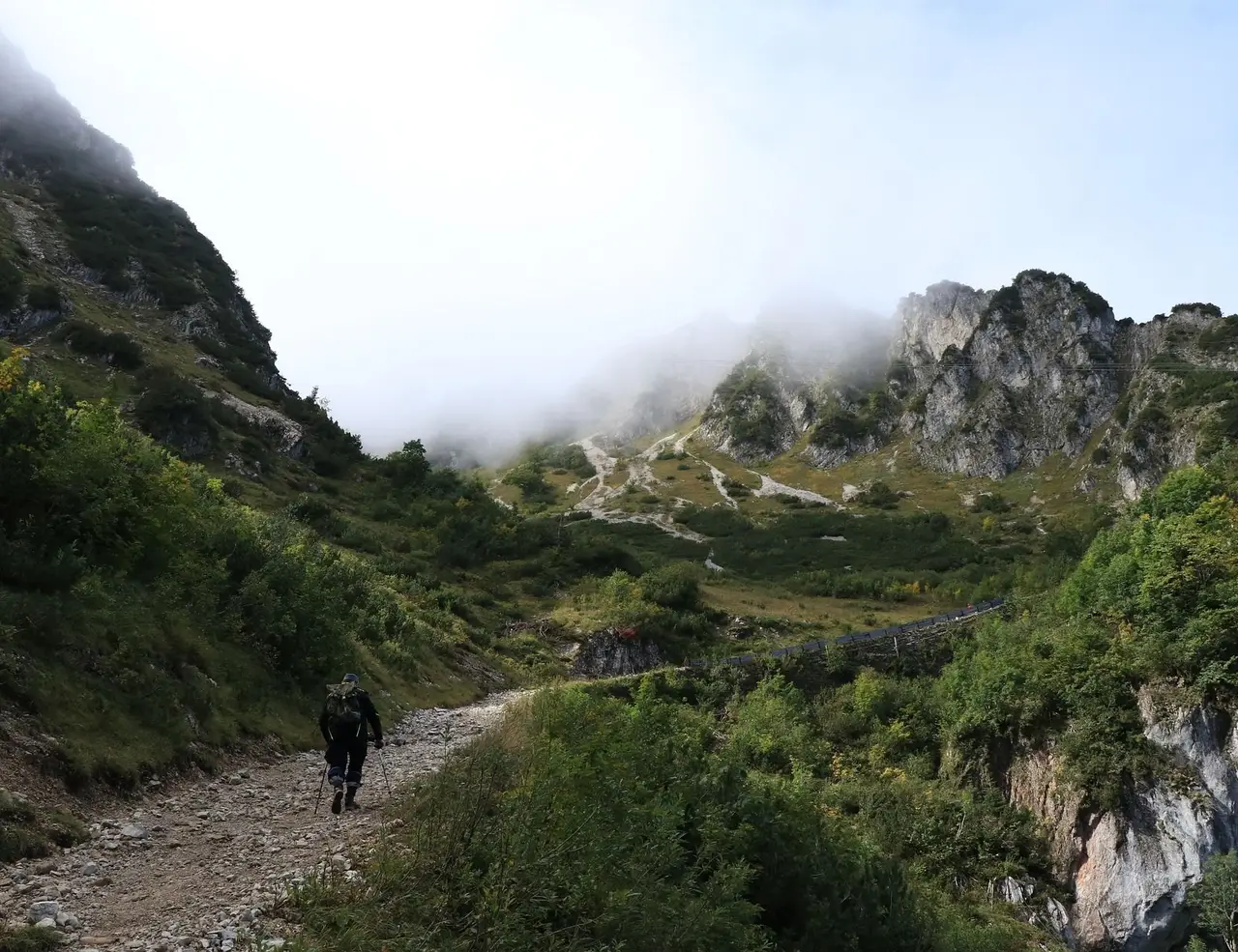
Which Are the Best Sections of the Via Dinarica?
Very few hikers complete the entire White Trail in one go. Most approach it in sections, spending a week in Croatia, another in Bosnia, a third in Montenegro, and this is a sensible way to do it. The sections below represent the highlights of Via Dinarica hiking, based on trail quality, scenery, cultural immersion, and logistical accessibility.
Slovenia: Nanos Plateau and the Karst Heartland (The Gateway)
The Via Dinarica officially begins at Postojna, where the world's second-largest cave system tunnels through the limestone plateau beneath the trail. The opening stages climb the Nanos plateau above the Vipava Valley, a wide, wind-exposed karst shelf with views that reach across to the Julian Alps on clear days. Ljubljana, Slovenia's compact and thoroughly likeable capital, serves as the practical base before you set out.
The Slovenian section sets the geological tone for everything that follows. The karst landscape, with its sinkholes, cave systems, dry riverbeds, and pale rock, is at its most concentrated here. The trail infrastructure in Slovenia is among the best on the route: well-marked, well-serviced, with an excellent network of mountain huts. It is also the section where hiking in the Via Dinarica feels most integrated into a broader European hiking culture.
Quick Facts: Slovenia Difficulty: Moderate Start Point: Postojna Highlights: Postojna Caves, Nanos Plateau, Julian Alps views, best hut infrastructure on the route Base City: Ljubljana
Croatia: The Velebit Mountains (The Trail at Its Most Complete)
Of all the sections on the Via Dinarica White Trail, the Velebit traverse in Croatia is the most consistently excellent. The Velebit is a long, narrow mountain range that runs parallel to the Adriatic coast for 145 km (90 mi), and the hike along its main ridge, following sections of the famous Premuzic Trail, is spectacular. To the west you look down over the Dalmatian islands and the blue Adriatic. To the east, the Lika plateau stretches toward Bosnia. On a clear day, Italy is visible.
The Premuzic Trail itself, engineered in the 1930s with extraordinary care for the landscape, remains in excellent condition. Northern Velebit National Park, where the trail begins its ridge traverse, is also home to Hajducki Kukovi, a surreal zone of white limestone towers and arches that feels like nothing else in Europe. The hut network on the Velebit is functional and well-spaced, making multi-day hut-to-hut hiking genuinely practical. Be prepared for the bora wind: it arrives without warning and with significant force.
The Croatian section continues south to Paklenica National Park, a rock-climbing and hiking paradise wedged between two dramatic limestone gorges at the southern end of the Velebit. Paklenica is also where Via Dinarica hiking in Croatia turns distinctly Balkan in character: the terrain grows harder, the trails less maintained, and the distances between huts longer. It is an appropriate transition.
Quick Facts: Croatia Difficulty: Moderate to Challenging Best Stretch: Premuzic Trail through Northern Velebit National Park Highlights: Adriatic ridge views, Hajducki Kukovi rock formations, functional hut network, Paklenica gorge Watch Out For: Bora wind, which arrives suddenly and with significant force
Bosnia and Herzegovina: Prenj, Cvrsnica, and Sutjeska (The Soul of the Trail)
If the Velebit is the most polished section of the Via Dinarica, the Bosnian highlands are the most affecting. The mountains here, including Prenj, Cvrsnica, Visocica, and Bjelasnica, are not well-known internationally, but they are formidable. Prenj in particular is often called the Herzegovinian Himalaya by local hikers, a nickname that exaggerates but gestures toward something real: these are high, serious mountains with demanding routes, minimal infrastructure, and dramatic scenery.
Sutjeska National Park, in southeastern Bosnia near the Montenegrin border, is one of the highlights of hiking in the Via Dinarica anywhere. It contains Perucica, one of the last old-growth primeval forests in Europe, where beeches reach 50 m (164 ft) and the forest floor has been undisturbed for centuries. The park's highest point, Mount Maglic at 2,386 m (7,828 ft), is the highest peak in Bosnia and Herzegovina and sits directly on the border with Montenegro, a summit that rewards the effort with views across two countries and into a third.
Lukomir, perched at 1,469 m (4,819 ft) above Sarajevo, is the highest permanently inhabited village in Bosnia and one of the most extraordinary places on the route. Its residents still follow transhumant traditions, living here from spring to autumn and descending to the valley in winter. The traditional stone houses, the necropolis of medieval stecak tombstones on the hillside, and the views across the Rakitnica Canyon make it a worthy detour even for non-thru-hikers. Sarajevo, capital, 1984 Winter Olympic host city, and one of Europe's most genuinely interesting urban destinations, is the natural base for this section.
Quick Facts: Bosnia and Herzegovina Difficulty: Challenging High Point: Mount Maglic, 2,386 m (7,828 ft) — highest peak in BiH Highlights: Sutjeska NP, Perucica old-growth forest, Lukomir village, stecak tombstones Base City: Sarajevo Safety Note: Download the BH Mine Suspected Areas app before hiking in Bosnia
Montenegro: Durmitor National Park (High Alpine Drama)
Durmitor is, by most measures, the crown jewel of Via Dinarica hiking. This UNESCO-designated national park in northern Montenegro is a high-alpine massif of limestone peaks, glacial lakes, and deep canyon systems that has no real equivalent elsewhere on the trail. Bobotov Kuk, the park's highest point at 2,523 m (8,278 ft), involves a full summit day with serious elevation gain and the kind of reward that justifies it. The glacial lakes scattered across the plateau, including Skrka, Zminje, and Valovito, are clear, cold, and swimmable in summer.
The Tara River Canyon forms the northern boundary of Durmitor and at 1,300 m (4,265 ft) deep it is one of the natural wonders of Europe. Rafting the Tara is a standard complement to hiking the Via Dinarica in this section, a full-day run through a canyon so deep and remote that it has barely changed since the river carved it. Zabljak is the park's main town and a functional base with accommodation ranging from basic mountain huts to comfortable hotels.
Beyond Durmitor, the Montenegrin section of the White Trail changes character, moving through smaller villages and more pastoral terrain before approaching the Albanian border. This stretch is quieter and less dramatic than the national park but offers genuine engagement with Montenegrin rural life, landscapes shaped by centuries of pastoral use, and a sense of transition toward the wild finale of the route.
Quick Facts: Montenegro High Point: Bobotov Kuk, 2,523 m (8,278 ft) Key Features: 18 glacial lakes, Tara Canyon — 1,300 m (4,265 ft) deep (2nd deepest in the world), UNESCO designation Difficulty: Challenging Base Town: Zabljak Add On: Tara River rafting pairs naturally with the hiking section here
Albania and Kosovo: Prokletije (The Accursed Mountains)
The Prokletije, literally 'the accursed mountains', form the southern terminus of the White Trail and constitute one of the most remote and spectacular landscapes in Europe. Straddling the tri-border of Albania, Montenegro, and Kosovo, this is a range of jagged peaks, deep-cut valleys, thundering waterfalls, and isolated shepherd villages that sees only a fraction of the hikers who visit better-known European mountain areas. The Albanian Alps, the Peaks of the Balkans trail, and the Via Dinarica all converge here.
The village of Theth in Albania is the gateway. Accessed by a road that seems designed to deter the faint-hearted, it is a cluster of stone houses in a glacially carved valley beneath limestone walls. The hospitality here is extraordinary, centered around family guesthouses that serve as the social and logistical hub of the hiking community in the region. From Theth, trails connect to Valbona through the Valbona Pass, one of the most celebrated single-day walks in the Balkans, and onward into the three-border zone.
Quick Facts: Albania and Kosovo Character: Remote, wild, minimal formal infrastructure Gateway: Theth (Albania) or Plav (Montenegro) Highlights: Three-border point, Valbona Valley, glacier lakes, stone village guesthouses Best Combined With: Peaks of the Balkans trail circuit Difficulty: Challenging to very challenging; tent essential for remote sections
PLANNING A HIKING HOLIDAY IN VIA DINARICA ?
Dive into our curated Via Dinarica hiking adventures today!
Food and Drink Along the Via Dinarica: Eating Your Way Through the Balkans
Food is not a footnote on this trail. Eating your way through the countries of the Via Dinarica is one of the genuine pleasures of the journey, and the variety on offer across 1,200 kilometers is remarkable. The cuisine shifts with every border crossing, but a few threads run through the whole route: fresh dairy, grilled meat, wild herbs, and the kind of hospitality that means you will rarely leave a table hungry.
Slovenia and Croatia: Mediterranean Meets Alpine
The Slovenian section of the trail sits at a culinary crossroads. Mountain huts serve hearty soups, goulash, and buckwheat dishes that reflect the Alpine tradition, while the Vipava Valley below the Nanos plateau produces some of Slovenia's best wine and olive oil. On the Croatian Velebit, the food is simpler but satisfying: lamb slow-cooked under a peka (a domed cast-iron lid buried in embers), sheep's cheese cured in olive oil, and prsut, the air-dried ham that is one of the great cured meats of the Mediterranean world. On the Blue Trail along the coast, fresh fish and seafood define every meal.
Bosnia and Herzegovina: The Ottoman Kitchen
Bosnian food carries the DNA of Ottoman cuisine more clearly than anywhere else on the route. Cevapi, small grilled sausages of minced beef and lamb served in flatbread with raw onion and kaymak (a thick clotted cream), is the national dish and available at almost every village stop. Burek, a flaky pastry filled with meat, cheese, or spinach, is the breakfast of choice from Sarajevo to the most remote highland village. In the mountains, expect lamb, corn bread called somun, and whatever vegetables are growing in the household garden. The coffee culture here is serious: Bosnian coffee, brewed in a small copper dzezva and poured slowly over the grounds in a small cup, is its own ritual, and refusing a second cup is considered mildly impolite.
Montenegro: From the Mountains to the Bay
Montenegrin food splits cleanly between the coast and the interior, and hiking in the Via Dinarica takes you through both. In the mountains around Durmitor, the diet is built on smoked lamb, dry-aged prosciutto called njeguski prsut (from the village of Njeguci, which considers itself the spiritual home of the product), sheep's and goat's cheese, and wild mushrooms gathered from the forest. At the katuns on the high plateau, cheese and sour milk are produced daily and offered to passing hikers as a matter of course. Descend toward the Bay of Kotor on the Blue Trail and the menu shifts entirely: grilled fish, black risotto, and wine from the Crmnica valley.
Albania: Wild Flavors at the End of the Trail
Albanian mountain cuisine in the Prokletije region is simple, seasonal, and exceptional. The guesthouses of Theth and Valbona serve meals built around what is available: fresh trout from the mountain streams, flia (a slow-cooked layered crepe dish that takes hours to prepare and is considered a mark of respect toward guests), white bean soup, and hand-pulled cheese. Raki, the fruit brandy that functions as the universal social lubricant across the Balkans, is offered before, during, and after most meals in Albania, often from an unlabeled bottle and at a strength that should not be underestimated. Drinking it is part of the hospitality exchange. Declining politely is an art form worth practicing.
Practical Notes on Trail Eating
In remote sections of the White Trail, resupply opportunities are limited and you will be carrying most of your food. Stock up thoroughly in valley towns before ascending to any multi-day ridge section. Mountain huts that serve meals are noted in the official Via Dinarica guide, but verify current status before depending on them. In Albania particularly, the guesthouse meal system is the backbone of hiker nutrition and it works well, but it requires advance communication. A few words of Albanian or a translation app goes a long way.
Accommodation Options for Hiking the Via Dinarica
Accommodation on the Via Dinarica ranges from excellent to non-existent, sometimes within a single day's walk. Understanding the accommodation landscape by type rather than by country is the most useful way to plan.
Mountain Huts
The mountain hut network is the backbone of the Via Dinarica's accommodation system, and it varies enormously. Croatia's Velebit has a functioning, well-distributed set of huts, some staffed, some unmanned, nearly all usable. Montenegro's Durmitor has staffed huts through the summer months. Bosnia is patchier: some huts are excellent, run by local mountain clubs that offer meals and a warm welcome; others marked on the official map are locked, abandoned, or inaccessible without prior arrangement. Always verify hut opening status before departing for a remote section. Prices are typically 5 to 15 euros per person per night.
Katuns and Shepherd Lodges
In Bosnia and Montenegro particularly, the seasonal shepherd settlements (katuns) become informal accommodation for hikers who arrive and ask. This is not a formal system. It depends on timing, since katuns are occupied June through September, and on the hospitality of whoever is there. In practice, it works often enough that experienced hikers factor it into their planning. You will typically get a space to sleep, something to eat, and a window into a way of life that has remained essentially unchanged for generations.
Village Guesthouses
Family-run village guesthouses are the most reliable form of accommodation in the more populated sections of the trail. They are typically simple: a bed, a shared bathroom, a meal cooked from whatever is growing in the garden. In Albania, the guesthouse system in Theth and Valbona is well-organized and caters specifically to hikers, with families who understand trail logistics, can provide packed lunches, and will often arrange onward transport. These stays are frequently the most memorable of a Via Dinarica trip.
Wild Camping
Wild camping is a practical reality for many Via Dinarica hikers, particularly on the longer remote sections. The legal picture varies: it is prohibited in Slovenia and within the national parks of Croatia and Montenegro (Durmitor has a small designated camping fee of 3 to 5 euros per tent per night). Outside park boundaries, enforcement is minimal and the tradition of camping on open mountain land is culturally accepted. The standard leave-no-trace practice applies throughout. On the most remote sections of the Albanian Prokletije, a tent is not optional.
Planning and Logistics: What to Know Before You Go
The Via Dinarica is not a trail you can navigate on confidence alone. The logistics require attention, and the gaps between planning and reality can be significant. Here is what matters most.
Navigation and GPS
The official GPX tracks for all three Via Dinarica trails are available on the via-dinarica.org website. Download them before departure and load them onto a dedicated GPS device or reliable offline mapping app. Mapy.cz and Maps.me are both recommended by experienced hikers on this route. Do not rely on phone signal for navigation: the most interesting sections of the trail have none. Paper maps, where available, are useful supplements. The official Croatian, Bosnian, and Montenegrin national park maps can be purchased at park offices and some mountain huts.
Waymarking is one of the trail's genuine challenges. The Croatian Velebit is well-signed. Bosnia is inconsistent, with some sections clearly marked and others requiring regular GPS consultation. The Albanian Prokletije is minimally marked. Budget extra time on any section described as remote or unmarked.
Border Crossings on Foot
Several of the official Via Dinarica GPX tracks cross at unofficial border points that are not staffed or legally designated for foot traffic. Crossing at non-official points can result in fines, and the Croatia-Bosnia border in particular is strictly enforced since Croatia's accession to the EU and Schengen. Research each border crossing in advance, carry your passport at all times, and arrange transport through official checkpoints where the trail crosses improperly. The Montenegro-Albania border through the Prokletije can also be unclear on the ground; verify current crossing conditions before departing.
Currency, Resupply, and Cash
Currency varies by country: Slovenia, Croatia, and Montenegro use the euro; Bosnia uses the Convertible Marka (BAM); Albania uses the Lek. Card payments are uncommon in mountain areas. Carry sufficient cash at all times, particularly when entering remote sections. Resupply opportunities vary dramatically. Some sections allow you to stock up in valley towns every two or three days; others require carrying five to seven days of food. Plan resupply points in advance.
Safety in Bosnia: Landmine Awareness
Some areas of Bosnia and Herzegovina remain affected by landmines from the 1990s conflict. The established Via Dinarica White Trail route has been cleared, but hikers who deviate from marked paths should exercise caution. The BH Mine Suspected Areas app provides real-time mapping of suspect zones and is essential for anyone hiking in Bosnia. Do not enter unmarked off-trail areas, particularly in the Herzegovinian highlands.
READY TO HIKE THE VIA DINARICA?
Get started with your Hiking adventure now!
Frequently Asked Questions About Hiking the Via Dinarica
Is hiking the Via Dinarica safe?
For well-prepared hikers who stick to marked routes, yes. The main safety considerations are: mountain weather changes rapidly and can be severe; some sections of the White Trail require genuine mountaineering competence in early season; landmine awareness is essential in parts of Bosnia; and border crossing procedures must be followed correctly. The trail is not inherently dangerous, but it is not forgiving of poor preparation.
Do I need a guide?
Not necessarily, but a guide adds real value, particularly in Bosnia and the Albanian Prokletije, where trail conditions are most challenging and the cultural dimension of the hike is most rewarding when you can actually communicate with people you meet. Guided section tours allow you to focus on the experience without the logistical overhead of independent thru-hiking.
Can I hike just one country?
Absolutely, and this is how most people approach it. A week in the Croatian Velebit, a week in Bosnia centered on Sutjeska and Bjelasnica, or five days in Durmitor are all coherent standalone experiences. The Via Dinarica is designed to be explored in sections.
Are border crossings allowed on foot?
At official crossings, yes. The challenge is that some sections of the official GPX route cross at unofficial points. Research each border crossing before departure and always use official checkpoints. Carry your passport at all times.
How difficult is the Via Dinarica?
The White Trail is a challenging long-distance route. Some sections are moderate and suitable for regular hikers with good fitness. Others, including the high Herzegovinian massifs, the summit day on Maglic, and the upper Prokletije, require experience in alpine terrain, comfort with navigation, and appropriate equipment. Rate each section individually rather than assigning a blanket difficulty level.
Is wild camping legal?
It varies. Wild camping is prohibited in Slovenia and in designated national parks across Croatia and Montenegro. It is tolerated, and practically necessary, in many other sections. In Albania, wild camping is widespread and accepted. Follow leave-no-trace principles throughout.
Is the trail crowded?
No. Thru-hikers on the Via Dinarica routinely report going days without seeing another long-distance hiker. Popular sections like the Velebit attract day hikers and weekenders, and Durmitor draws tourists to its lake circuits, but the trail itself is among the least crowded long-distance routes in Europe. This is part of its appeal.
What fitness level do I need?
For the White Trail, a solid base of multi-day hiking experience is the minimum. You should be comfortable covering 20 to 25 km (12 to 15 mi) per day with a loaded pack on uneven terrain. For the Blue Trail along the coast, the fitness requirement is considerably lower. Build your mileage before departure and do not underestimate the cumulative effect of several consecutive days at elevation.
Is the Via Dinarica Right for You?
Hiking the Via Dinarica asks something of you that more established European trails do not. It asks for patience with imperfect infrastructure, comfort with navigational uncertainty, a willingness to communicate across language barriers, and enough flexibility to adapt when the plan does not survive contact with the terrain. In return, it offers a quality of wilderness, cultural depth, and genuine remoteness that is increasingly rare on a continent where most long-distance trails are thoroughly managed.
The Balkans are changing fast. The trail communities that make hiking in the Via Dinarica so distinctive, the katun families in Montenegro, the guesthouse operators in Theth, the mountain club members who maintain the Bosnian huts, are already part of a tourism economy that is growing. Hiking the Via Dinarica now means experiencing the region while it still feels genuinely undiscovered. That window is open. It will not stay open indefinitely.
