Hiking Guides | Last updated:
The Complete Guide to Hiking The Michinoku Coastal Trail
By Shivangi Vaswani •
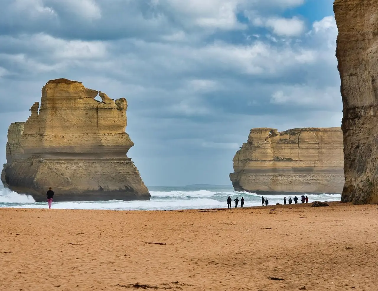
Table of Contents
- 1. Overview
- 2. Location
- 3. Getting There
- 4. The Michinoku Coastal Trail Etymology and History
- 5. Best Time for Hiking in the Minchinoku Coastal Trail
- 6. Which Are the Best Routes for Hiking the Michinoku Coastal Trail?
- 7. Accommodation Options on the Michinoku Coastal Trail Hiking Trail
- 8. Frequently Asked Questions
Overview
The Michinoku Coastal Trail, tracing the shoreline of Japan’s northeastern Tohoku region, is one of the country’s most compelling long-distance walks and a journey through landscapes shaped by the sea. Stretching for over a thousand kilometers from Hachinohe in Aomori Prefecture to Soma in Fukushima, the route passes through fishing villages, pine-covered headlands, and sweeping beaches that reveal both the beauty and resilience of this coast. Created as part of the region’s recovery after the 2011 Great East Japan Earthquake, it connects people and places through a shared story of renewal.
The path follows the rhythm of the Pacific Ocean, weaving between wild cliffs, quiet coves, and stretches of farmland where the salt wind drifts inland. In spring, wildflowers bloom along the dunes; in summer, the sea glows a deep blue beneath warm skies; autumn brings clear light and golden grasses; and winter lays a calm hush over the harbors. Every season carries its own expression of the coast, shifting gently as you walk.
Many hikers explore the northern and central sections, such as the grassy Tanesashi Coast or the dramatic Kitayamazaki cliffs, where the trail threads through forests and viewpoints high above the waves. Others wander through towns like Miyako or Kesennuma, where seafood markets, temples, and coastal cafés offer a glimpse into daily life by the sea. The full route, passing through four prefectures, rewards those who move slowly and take time to listen to both the ocean and the communities that line its edge.
Hiking the Michinoku Coastal Trail is as much about connection as it is about scenery. Staying in family-run inns, sharing local seafood dinners, soaking in seaside hot springs, and talking with residents who have rebuilt their lives beside the water all give the journey its depth.
Whether you come for the open horizons, the quiet rhythm of coastal walking, or the chance to walk through a living landscape of recovery and renewal, hiking the Michinoku Coastal Trail offers an experience that blends nature, culture, and heartfelt Japanese hospitality.
DREAMING OF HIKING THE MICHINOKU COASTAL TRAIL? ?
Explore our amazing hiking tours in japan now!
Location
The Michinoku Coastal Trail traces Japan’s northeastern shoreline through a landscape of bays, cliffs, and small fishing settlements shaped by the Pacific Ocean. The terrain is ever-changing, with grassy headlands giving way to forested ridges, long beaches opening into rocky coves, and narrow paths climbing above the sea before dipping back toward harbors where life moves to the rhythm of the tides.
In the north, the trail passes the open meadows of the Tanesashi Coast and the soaring cliffs of Kitayamazaki, where lookout points reveal vast views of the Sanriku coastline. Around Miyako and Kamaishi, it threads through quiet pine forests and seaside towns before entering the gentler southern stretches of Miyagi and Fukushima, marked by wide bays and agricultural plains. Most of the route stays close to sea level, with occasional climbs under 400 meters that offer sweeping panoramas of ocean and sky.
The geography of this region gives the trail its distinct character. The Sanriku ria coastline, carved by deep inlets and high headlands, creates a sequence of dramatic natural forms that alternate between rugged and calm. Inland, terraced fields and rivers add softer tones to the scenery, while national park areas preserve sections of untouched coastal forest and habitat for seabirds and wildflowers.
Though it traverses one of Japan’s most remote regions, the Michinoku Coastal Trail remains well connected. Rail and bus routes run parallel to much of the coastline, linking trailheads and nearby towns. This makes it easy to walk individual sections or combine longer stretches without the need for complex logistics, allowing hikers to experience both the wildness and accessibility of Japan’s northeastern coast.
Getting There
Although it stretches across a remote and varied coastline, the Michinoku Coastal Trail is well served by Japan’s extensive transport network. The northern trailhead begins near Hachinohe in Aomori Prefecture, while the southern end lies in Soma, Fukushima. Most hikers choose to explore shorter sections in Iwate or Miyagi Prefectures, where access by train and bus is easy from major cities such as Tokyo and Sendai.
Because the trail follows the Pacific coast, several coastal towns act as convenient entry points. Hachinohe and Kuji in the north, Miyako and Kamaishi along the central section, and Kesennuma or Ishinomaki in the south all have rail links, visitor centers, and accommodation options for hikers. These towns serve as practical bases for exploring nearby trail segments or planning multi-day walks.
By Air
The nearest major international gateways are Tokyo’s Haneda and Narita airports. From Tokyo, high-speed trains connect directly to the Tohoku region, reaching Hachinohe in about three hours. Domestic flights to Aomori, Iwate-Hanamaki, or Sendai airports provide faster regional access, especially for travelers focusing on particular sections of the trail. Sendai Airport is especially convenient for hikers beginning in Miyagi Prefecture or heading toward Fukushima.
By Rail
Japan’s high-speed rail network makes reaching the Michinoku Coastal Trail straightforward. From Tokyo, take the Tohoku Shinkansen to Hachinohe, Morioka, or Sendai, depending on your chosen starting point. From there, local lines such as the Hachinohe Line, Sanriku Railway Rias Line, and JR Joban Line run along the coast, stopping at towns that connect directly to the trail. Rail passes like the JR East Pass can be used on most routes, making multi-section travel affordable and flexible.
By Bus or Road
Local bus services complement the rail network, linking smaller coastal communities and trailheads where train access is limited. Timetables are coordinated with train arrivals, allowing smooth transfers between major towns and trail sections. For those renting a car, coastal highways such as Route 45 and Route 6 parallel much of the trail, offering easy access to accommodations, visitor centers, and scenic viewpoints.
From the bustle of Tokyo or Sendai, the journey northward gradually opens into a quieter world of sea cliffs, pine forests, and fishing ports. Within a few hours of leaving the city, you find yourself walking beside the Pacific, where the sound of the waves replaces the rush of trains and the pace slows to meet the rhythm of the coast.
The Michinoku Coastal Trail Etymology and History
The name “Michinoku” is an old poetic term for Japan’s northeastern region, Tohoku. It is thought to derive from the phrase michi no oku, meaning “the far-off land” or “the deep end of the road,” a reflection of how distant this area once felt from the political and cultural centers of Kyoto and Edo. The trail’s full name, the Michinoku Coastal Trail, connects that sense of remoteness with the Pacific coastline that defines the region’s identity.
For centuries, these shores were home to fishing communities, merchants, and pilgrims who moved along narrow paths linking villages and ports. Long before it became a defined hiking route, people traveled these same headlands and inlets to trade seafood, salt, and handmade goods. The coast also held deep spiritual meaning, with shrines and temples dedicated to sea deities that offered protection for those who lived by the water.
The modern trail was conceived after the 2011 Great East Japan Earthquake and tsunami, which devastated much of the Tohoku coast. In the years that followed, local governments, volunteers, and the Ministry of the Environment came together to create a long-distance path that would both support recovery and celebrate the region’s natural beauty. The project became part of the Sanriku Fukko National Park initiative, symbolizing resilience and the bond between people and the sea.
Today, the Michinoku Coastal Trail stretches across four prefectures: Aomori, Iwate, Miyagi, and Fukushima, linking communities that rebuilt their towns in the shadow of the ocean. It passes memorial sites and lookout points that remind travelers of the past, but also introduces them to new guesthouses, cafes, and local guides who represent the region’s renewal. Walking the trail is both a physical and emotional journey, one that invites reflection on nature’s power and the human capacity to coexist with it.
While the route itself is new, its spirit is ancient. The Michinoku name carries echoes of the past, and the trail continues the long tradition of Japanese pilgrimage and travel on foot. It connects not only landscapes but generations, bridging history and the present through the simple act of walking along the edge of the sea.
PLANNING A HIKING HOLIDAY IN MICHINOKU COASTAL TRAIL?
Dive into our curated Japan hiking adventures today!
Best Time for Hiking in the Minchinoku Coastal Trail
With much of the Michinoku Coastal Trail following sea-level routes, hiking conditions are generally mild throughout the year. The region’s coastal climate is cooler than many parts of Japan, shaped by the Pacific Ocean’s winds and the northern latitude of the Tohoku region. Weather can change quickly, but from spring to autumn the air is clear, the scenery vibrant, and temperatures comfortable for long days on the trail.
Best Seasons – Spring (April to June) and Autumn (September to November)
Spring
From April to June, the coast comes alive with new color and warmth. Wildflowers bloom along grassy dunes, cherry blossoms appear in parks and fishing towns, and the sea takes on a deep, calm blue. Temperatures average between 8°C and 18°C (46°F to 64°F) in April, rising to around 20°C (68°F) by early June. This is one of the most comfortable and scenic times for hiking the Michinoku Coastal Trail, with long daylight hours and a fresh, salt-scented breeze. The northern sections around Aomori and Iwate are particularly striking, with spring wildflowers covering the Tanesashi Coast and the forests around Kitayamazaki turning a bright, new green.
Autumn
Autumn is often considered the best time for hiking in Tohoku. From late September to November, the air turns crisp, humidity drops, and the coast glows with golden grasses and red foliage. Daytime temperatures usually range from 12°C to 20°C (54°F to 68°F), making for comfortable walking conditions. In Iwate and northern Miyagi, forests above the cliffs shift into vivid autumn tones, while seafood markets overflow with seasonal catches like Pacific saury and oysters. It is a quieter season than spring, offering ideal conditions for long-distance hikers and photographers alike.
Shoulder Seasons – Summer (July to August) and Winter (December to March)
Summer
July and August bring warm, humid weather to the coast, with average highs between 25°C and 30°C (77°F to 86°F). While mornings and evenings remain pleasant, daytime hiking can feel hot, especially in sheltered sections away from the sea breeze. Rain showers and occasional typhoons may affect travel plans, but the trail is fully open and the ocean offers welcome relief for cooling off. Many local festivals take place in summer, giving hikers the chance to experience Tohoku’s lively culture, fireworks, and fresh seafood served outdoors in fishing ports.
Winter
Winter transforms the coast into a quieter, more contemplative landscape. Temperatures average between -1°C and 8°C (30°F to 46°F), and while heavy snow is rare along most coastal sections, inland paths and higher viewpoints may become icy or closed. Days are shorter, but the clear air brings dramatic views of the sea and sky, and accommodations are peaceful with warm meals and hot springs waiting at day’s end. For experienced hikers prepared for cold weather, winter offers solitude and a chance to see the Michinoku coast at its most serene.
Which Are the Best Routes for Hiking the Michinoku Coastal Trail?
The Michinoku Coastal Trail extends for more than 1,000 kilometers along the Pacific coast of Japan’s Tohoku region, yet most hikers explore it in shorter sections that balance accessibility, scenery, and local character. Each area reveals a distinct mood, from grassy headlands and steep sea cliffs to fishing villages and pine forests alive with seabirds. Whether you have a few hours or several days, these are some of the most rewarding routes for hiking the Michinoku Coastal Trail.
1. Tanesashi Coast (Hachinohe to Kuji, Aomori Prefecture)
One of the most iconic and accessible sections, the Tanesashi Coast offers gentle terrain and sweeping ocean views. The trail passes through rolling meadows, sandy beaches, and the Tanesashi Natural Lawn, where seasonal flowers like Japanese iris and seaside daisy color the landscape. Wooden boardwalks trace the edge of the sea, and small cafés in Hachinohe serve fresh seafood before or after the walk. This section is ideal for beginners and day hikers who want to feel the open expanse of northern Japan’s coastline.
Quick Facts
Distance: ~25 km (15.5 mi) Time Needed: 1–2 days Difficulty Level: Easy Highlights: Tanesashi Natural Lawn, Kabushima Shrine, coastal flowers, ocean views at sunrise
2. Kitayamazaki to Kurosaki (Iwate Prefecture)
This stretch is often described as the most dramatic part of the entire trail. The path winds along the towering cliffs of Kitayamazaki, where observation decks and lookout towers open onto views of sea stacks, arches, and distant islands. The area is known as the “Alps of the Sea” for its vertical grandeur, with cliffs rising more than 200 meters above the waves. Steep stairways and winding forest trails make it a slightly challenging walk, but every climb rewards hikers with unforgettable coastal panoramas. In spring and autumn, mist rises from the ocean, adding an almost ethereal atmosphere to the cliffs.
Quick Facts
Distance: ~10 km (6 mi) Time Needed: 3–4 hours Difficulty Level: Moderate Highlights: Kitayamazaki cliffs, panoramic lookouts, sea caves, coastal pine forests
3. Jodogahama to Miyako (Iwate Prefecture)
Famous for its bright white rock formations and calm turquoise bays, this section showcases the softer side of the Sanriku coast. The trail meanders through pine groves and sheltered inlets, leading down to the crescent-shaped Jodogahama Beach, where the water is clear and still. Visitors can pause for a swim or a short boat tour among the rocks before continuing toward Miyako. Cafés and viewpoints dot the route, and it is one of the best areas to combine hiking with time by the sea. Easy terrain and gentle elevation changes make this walk suitable for families, photographers, and travelers looking for a relaxed half-day hike.
Quick Facts
Distance: ~8 km (5 mi) Time Needed: 2–3 hours Difficulty Level: Easy Highlights: Jodogahama Beach, Miyako Bay, white limestone rocks, calm swimming coves
4. Kesennuma to Minamisanriku (Miyagi Prefecture)
This middle section blends scenic walking with meaningful cultural encounters. The route passes through fishing ports, coastal markets, and small shrines where local fishermen still pray for safety at sea. Starting in Kesennuma, hikers can visit the Uminoichi Market to sample freshly caught seafood before setting out. The path then follows quiet roads and wooded lanes toward Minamisanriku, a town known for its resilience and warmth. Along the way, travelers can see both memorials and newly built homes that speak to the spirit of recovery after 2011. Spending a night in a local guesthouse here offers a memorable exchange with residents who have rebuilt their lives by the water.
Quick Facts
Distance: ~30 km (18.5 mi) Time Needed: 2 days Difficulty Level: Moderate Highlights: Fishing villages, Kesennuma Uminoichi Market, local guesthouses, coastal community life
5. Full Thru-Hike (Hachinohe to Soma)
For those seeking a complete immersion in Japan’s northeastern coastline, the full Michinoku Coastal Trail offers an unparalleled journey. Covering roughly 1,025 kilometers through four prefectures, it takes about 50 to 60 days to complete at a steady pace. The route connects every kind of landscape, from grassy dunes and cliffs to ports, forests, and rice fields that open onto the sea. Along the way, hikers encounter a mosaic of local cultures, regional cuisines, and the kindness of hosts who welcome travelers into family-run inns. Completing the entire trail is both a physical challenge and a reflective pilgrimage, tracing the resilience of coastal communities and the enduring relationship between Japan and the ocean.
Quick Facts
Distance: ~1,025 km (636 mi) Time Needed: 50–60 days Difficulty Level: Moderate to Strenuous Highlights: Entire Sanriku coastline, diverse terrain, cultural immersion, coastal hospitality
Accommodation Options on the Michinoku Coastal Trail Hiking Trail
One of the joys of hiking the Michinoku Coastal Trail is the chance to stay in small, family-run inns and guesthouses that embody the warmth and resilience of coastal Tohoku. Accommodations here range from traditional ryokan and minshuku to casual guesthouses, business hotels, and seaside lodges. Many are run by local families who rebuilt their homes and livelihoods after the 2011 earthquake, welcoming hikers with genuine hospitality, hearty seafood dinners, and insights into life by the sea.
Because the trail passes through inhabited areas, finding a place to stay is generally easy near the main access towns. Overnight stays often include breakfast and dinner, with meals featuring fresh fish, local vegetables, and regional specialties like sea urchin, scallops, and miso-flavored hot pots. While English may be limited in some places, the warmth of the hosts and the simplicity of Japanese hospitality make every stay memorable.
Here are some of the main accommodation highlights along popular sections of the Michinoku Coastal Trail:
1. Tanesashi Coast (Hachinohe to Kuji)
The Tanesashi area offers a relaxed start to the trail, with ocean-view hotels and coastal guesthouses that overlook grassy meadows and beaches. In Hachinohe, travelers can find modern hotels near the station, while smaller minshuku and seaside lodges dot the coast. Waking up to the sound of waves and watching the sunrise over the Pacific is a highlight of this northern section.
Accommodation Highlights: Ocean-view minshuku near Tanesashi Natural Lawn Modern business hotels in Hachinohe with easy transport access Seaside guesthouses offering fresh seafood breakfasts
2. Kitayamazaki to Kurosaki (Iwate Prefecture)
This area is more rugged and remote, but it offers a few rewarding stays close to the cliffs and national park viewpoints. Small inns and nature lodges near Kurosaki Park provide comfortable rest after a day of hiking steep coastal trails. Many of these accommodations include local seafood dinners and hot-spring baths that overlook the forest or sea. Staying here feels like retreating into the heart of the Sanriku coastline.
Accommodation Highlights: Ryokan and lodges near Kurosaki Park with onsen baths Family-run guesthouses in Tanohata village Simple minshuku with home-cooked seafood dinners
3. Jodogahama to Miyako (Iwate Prefecture)
Jodogahama and the surrounding Miyako area are well developed for visitors, offering a variety of stays from modern hotels to cozy ryokan overlooking Miyako Bay. Many inns here emphasize comfort and relaxation, with hot-spring baths and multi-course dinners featuring Iwate’s famous seafood. The proximity to both the beach and town makes this one of the most convenient bases for day hikes and sightseeing.
Accommodation Highlights: Seaside ryokan near Jodogahama Beach with hot-spring baths Hotels in central Miyako for easy access to the trail and restaurants Guesthouses and hostels for budget-friendly travelers
4. Kesennuma to Minamisanriku (Miyagi Prefecture)
This stretch combines scenic walking with a deeper connection to local community life. Many accommodations here are newly rebuilt and family-operated, blending modern comfort with heartfelt hospitality. In Kesennuma, larger hotels offer ocean views and seafood buffets, while in Minamisanriku, small inns and guesthouses invite conversation with hosts who share stories of the town’s recovery and renewal.
Accommodation Highlights: Rebuilt inns and hotels along Kesennuma Bay Family-run guesthouses in Minamisanriku with shared home-style meals Onsen hotels offering sea views and restorative baths
5. Multi-Day Thru-Hike or Long-Distance Sections
For hikers planning multi-day or long-distance routes, accommodations can be arranged night by night in towns spaced along the trail. Most stages end near a village or port with at least one inn or guesthouse. Some hikers mix traditional ryokan stays with simple business hotels, while others opt for camping where facilities allow. Booking in advance is recommended during weekends and national holidays, especially in summer and autumn when domestic travel peaks.
Accommodation Highlights: Combination of minshuku, ryokan, and business hotels along the route Occasional campgrounds and seaside lodges for flexible itineraries Meal-inclusive stays that showcase regional cuisine and local hospitality Whether you prefer a traditional tatami room, an ocean-facing onsen, or a simple seaside guesthouse, accommodations on the Michinoku Coastal Trail bring travelers closer to the heart of Tohoku’s coastal culture.
Frequently Asked Questions
What Is the Terrain Like and How Much of It Is on Roads?
The Michinoku Coastal Trail combines coastal paths, forest tracks, and paved roads that connect small fishing villages and towns. Because it was designed to link existing communities rather than cut through untouched wilderness, a significant portion of the route follows paved or gravel roads. Many hikers estimate that roughly half of the trail is on quiet rural roads, while the rest runs through beaches, headlands, and wooded areas.
Despite the road sections, the walking is rarely monotonous. The scenery changes constantly, with pine forests, rivers, cliffs, harbors, and farmland appearing along the way. There are frequent opportunities to stop at viewpoints, cafés, or local shrines. For those seeking more natural surroundings, the northern areas around the Tanesashi Coast and Kitayamazaki cliffs offer long, scenic stretches with fewer paved sections.
How Well Marked Is the Trail and Will I Have Mobile Signal?
Most parts of the Michinoku Coastal Trail are marked with the official blue and white logo, and signs appear at major junctions and access points. However, because the trail passes through both natural and residential areas, signage can be inconsistent in some stretches, especially in smaller villages or forest detours. Maps and direction boards are often in Japanese, with English limited to larger towns and visitor centers.
Carrying an offline map or GPS app is strongly recommended, particularly for those walking longer sections. Mobile phone signal is generally good near towns and main roads but can drop out in remote coastal areas or behind steep headlands. The official website provides downloadable route maps and GPX files, which are useful for navigation even without internet access.
Can I Camp Along the Trail or Must I Stay in Lodgings?
Camping is allowed only at designated campsites along the trail, of which there are around two dozen spaced across the four prefectures. These range from simple sites near fishing ports to scenic coastal campgrounds within Sanriku Fukko National Park. Facilities are basic but clean, usually offering toilets, running water, and occasionally showers. Advance reservations are recommended during weekends and holidays.
Wild camping outside these areas is discouraged to protect the environment and respect local communities. Most hikers choose to stay in ryokan, minshuku, or guesthouses instead, which are found near many trailheads and coastal towns. This approach not only provides comfort but also supports local businesses that have rebuilt their livelihoods through tourism.
Can I Hike Short Sections or Do I Need to Commit to a Multi-Day Trip?
The Michinoku Coastal Trail is highly flexible. You can walk it as a series of short day hikes, weekend trips, or longer multi-day journeys depending on time and interest. Each major town along the route connects to the rail or bus network, making it easy to start and finish almost anywhere.
Popular short hikes include the Tanesashi Coast, Jodogahama Beach, and the Kitayamazaki cliffs, which can all be completed in a few hours. For those wanting a deeper experience, linking two or three sections together creates a satisfying two to five day itinerary with overnight stays in small inns or onsen lodges. The trail’s accessibility and infrastructure make it welcoming to both first-time hikers and seasoned long-distance walkers.
READY TO HIKE THE MICHINOKU COASTAL TRAIL?
Get started with your Hiking adventure now!
Plan Your Active Adventure
Create a private trip or join a small-group departure.
