Table of Contents
- 1. Overview
- 2. Geography of Hiking in Scotland
- 3. History and Culture: Clan, Clearance, and Cairn
- 4. The Right to Roam in Scotland
- 5. Munro Bagging: A Scottish Tradition
- 6. Best Time for Hiking Scotland
- 7. Best Trails for Hiking in Scotland
- 8. Food and Drink in Scotland
- 9. Accommodation for Hiking in Scotland
- 10. Planning and Logistics
- 11. Frequently Asked Questions About Hiking in Scotland
Overview
Hiking Scotland is, in the most literal sense, hiking through one of the most legally open landscapes in the developed world. The Land Reform (Scotland) Act 2003 gives every person, resident or visitor, the right to access almost all land and inland water in the country for recreational purposes, provided they act responsibly. No fences, no private property signs, no permit requirements: if you can walk to it, you can walk on it. This is not simply a legal technicality. It shapes the entire experience of hiking in Scotland and places it in a different category from hiking almost anywhere else in Europe.
Within that open landscape sits a hiking environment of exceptional variety. Scotland contains 282 Munros, the Scottish Mountaineering Club's list of mountains over 3,000 ft (914 m), concentrated in the Highlands north and west of the Highland Boundary Fault. It has two national parks: the Loch Lomond and The Trossachs National Park in the south, and the Cairngorms National Park in the northeast, the largest national park by area in the UK. It has the most internationally celebrated long-distance trail in Britain, the West Highland Way, which has been drawing hikers from around the world since it opened in 1980. And it has the Isle of Skye, where the Black Cuillin ridge delivers the most technical mountain terrain in the British Isles, and where the Trotternish Peninsula offers some of the most photogenic walking on earth.
Hiking in Scotland requires honest preparation. The weather is famously variable and genuinely dangerous at altitude: summer storms build fast on exposed ridges, and the combination of wind and wet cold can produce hypothermia conditions even in August. Navigation skills matter here in a way they do not on waymarked European trails. On the Cape Wrath Trail, Britain's most demanding long-distance route, there are no waymarks at all for stretches of 30 km (19 mi) or more across roadless terrain. Even the West Highland Way carries warning signs about the consequences of being underprepared on Rannoch Moor. Scotland rewards hikers who respect the conditions. It is unforgiving to those who do not.
The other constant of hiking Scotland is the midge. Culicoides impunctatus, the Highland biting midge, emerges in significant numbers from late May through September, concentrating particularly in calm, damp conditions at dawn and dusk, and in sheltered valley locations. It does not carry disease, but it can make a still evening in the Highlands thoroughly miserable. Wind disperses midges effectively: open ridges and summits are largely free of them. The practical response is a midge net head covering, a quality DEET-based repellent, and choosing campsites on exposed ground with airflow.
This guide covers the geography, access rights, Munro bagging culture, best seasons, trail network, food, accommodation, and logistics for hiking in Scotland, with the detail needed to plan any level of trip from a first-time long-distance walk to a Cape Wrath Trail expedition.
DREAMING OF HIKING SCOTLAND?
Explore our amazing hiking tours in Scotland now !
Geography of Hiking in Scotland
Scotland occupies the northern third of the island of Great Britain and covers 77,933 sq km (30,090 sq mi). Its geography divides into three broad zones, each with its own character as a hiking environment. The Southern Uplands, from the English border north to the Central Belt, are rounded, moorland hills rising to around 840 m (2,756 ft) at their highest, crossed by long-distance routes including the Southern Upland Way. The Central Lowlands, the densely populated strip between Glasgow and Edinburgh, provide access gateways to both the Highlands and the islands. The Highlands, which begin at the Highland Boundary Fault running roughly from Helensburgh in the west to Stonehaven in the east, form the dominant hiking environment: a vast, sparsely populated mountain landscape covering more than half the country's land area.
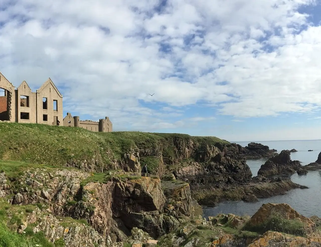
The Highland Boundary Fault is one of the most geologically significant lines in Europe. To its south, the rocks are younger sedimentary formations associated with the Central Lowlands. To its north, the Highlands are built on ancient Precambrian and Caledonian metamorphic rocks, some of the oldest geological material on Earth. The Torridonian sandstone of the northwest Highlands, found along sections of the Cape Wrath Trail near Torridon and Assynt, is approximately 750 to 800 million years old. The jagged gabbro and basalt of the Black Cuillin on Skye, by contrast, is geologically young at around 55 to 60 million years, formed from magma intruded during the opening of the North Atlantic. This geological youth is precisely why the Cuillin provides the most technical and grippy rock in the British Isles: the gabbro has not yet been worn smooth. Ben Nevis, at 1,345 m (4,413 ft), is the highest point in the British Isles. It sits above Fort William in the western Highlands, where the River Nevis drains into Loch Linnhe, and marks the southern terminus of the Cape Wrath Trail and the northern terminus of the West Highland Way. The Cairngorms massif in the northeast, centred on an ancient granite plateau, contains four of the five highest summits in the UK, including Ben Macdui at 1,309 m (4,295 ft), and represents the largest area of Arctic-alpine terrain in Britain: a high, cold, and genuinely demanding environment even in midsummer.
Scotland's western coastline is deeply indented by sea lochs carved by glaciation, giving the country a coastline of around 18,672 km (11,602 mi), the third longest national coastline in Europe. The sea lochs shape the hiking experience throughout the Highlands and Islands: crossings that look short on a map require boat ferries or long detours in practice. The Knoydart peninsula, the most remote section of the mainland UK, has no road access at all: it is surrounded on three sides by sea lochs and on the fourth by mountain passes accessible only on foot or by the Mallaig ferry. Knoydart forms one of the most significant sections of the Cape Wrath Trail.
Scotland has over 790 islands, of which around 93 are permanently inhabited. The Outer Hebrides, Inner Hebrides (including Skye, Mull, and Islay), Orkney, and Shetland each offer distinctive hiking environments, from the machair grasslands of the Hebridean coast to the Norse archaeology of Orkney and the dramatic clifftop walking of Shetland. Skye, connected to the mainland by road bridge since 1995, is the most visited island for hiking and the only island location for a Munro requiring technical climbing to reach the summit.
History and Culture: Clan, Clearance, and Cairn
History and Culture: Clan, Clearance, and CairnThe Highland landscape that hikers move through today was not always this empty. For most of recorded history, the Scottish Highlands supported a dispersed rural population organised around the clan system: extended kinship networks with shared territory, shared name, and shared loyalty to a chief. The clan system was not the romanticised tartan pageant of later Victorian imagination but a functional social and military structure that governed land use, conflict resolution, and collective survival in a challenging environment. Clan territories were not formally bounded by legal title but by custom and by force, and the mountains and glens were understood as productive spaces: grazed in summer by cattle driven to high shielings, hunted for deer and game, and crossed by drove roads that connected markets.
Two events in the 18th and 19th centuries emptied much of this landscape. The Battle of Culloden in 1746, where government troops crushed the Jacobite rising led by Charles Edward Stuart and killed or dispersed much of the Highland army, was followed by a systematic policy of cultural suppression: the wearing of tartan was banned, the bearing of arms forbidden, the power of clan chiefs legally dismantled. The clan system's social infrastructure never recovered. What followed, across the late 18th and early 19th centuries, was the Highland Clearances: the forced removal of tens of thousands of tenant farming families from their land to make way for more profitable sheep grazing. Communities that had occupied glens for centuries were evicted, often violently, with their stone buildings pulled down and their fields converted to grazing. The ruins of these settlements are visible on the hillsides throughout the Highlands: empty villages, roofless houses, the faint linear traces of rig-and-furrow cultivation in ground that has been empty for 200 years. Hiking in Scotland is hiking past this history.
The Gaelic language, Scots Gaelic, was the language of the Highlands for over 1,500 years and the native tongue of the majority of Scotland's rural population as recently as 1800. Today it is spoken by around 60,000 people, concentrated in the Western Isles, but its influence is inscribed on the landscape in every place name a hiker reads on a map or trail sign. Ben Nevis derives from Beinn Nibheis, meaning mountain of heaven or possibly venomous mountain, depending on interpretation. Loch comes from the Gaelic for lake or arm of the sea. Glen is gleann: a valley. Strath is a broad valley with a river. Beinn or Ben is a mountain. Sgurr is a sharp rocky peak. Bealach is a mountain pass. Learning a handful of Gaelic topographic terms does not give fluency, but it does give a way of reading the landscape that adds depth to the experience of hiking Scotland.
The Victorian period brought a second transformation of the Highlands, this one concerned with recreation rather than clearance. Queen Victoria and Prince Albert's acquisition of Balmoral in 1852 set a fashion for Highland retreats among the British aristocracy, and the construction of railways made the Highlands accessible to the prosperous middle classes of Edinburgh, Glasgow, and London. The Cairngorms and the western Highlands became grouse moors and deer forests managed for shooting; the mountains attracted the first generation of mountaineers and hillwalkers who would go on to form the Scottish Mountaineering Club in 1889, the organisation from which the Munro list would emerge two years later. The walking tradition that today draws hundreds of thousands of visitors to Scotland each year is rooted in this Victorian Alpine enthusiasm transplanted to a domestic setting.
The cairn, a pile of stones marking a summit or waypoint, is one of the oldest structures in the Scottish landscape. Neolithic cairns used as burial monuments dot the moorlands; Bronze Age cairns appear on ridgelines and hillsides across the country. The tradition continues: almost every Munro summit is marked by a cairn of modern construction, often substantial, built by successive generations of summiteers adding their stone. They function as navigational markers in mist, as evidence of prior passage, and as a small act of connection to everyone who has stood on the same spot. The cairn is one of the few genuine continuities between the prehistoric landscape and the contemporary hiking one.
The Right to Roam in Scotland
The Land Reform (Scotland) Act 2003 is the most significant piece of outdoor access legislation passed in the United Kingdom since the national parks were established in England and Wales in the 1940s, and it is considerably more permissive than its English equivalent. Under the Act, every person has the right to access most land and inland water in Scotland for recreation, education, and passage, provided they exercise that access responsibly. The rights are not limited to designated footpaths, national trails, or public rights of way. They extend across open moorland, forest, agricultural land (with specific exceptions), the banks of rivers and lochs, and the slopes of mountains, regardless of whether the land is publicly or privately owned.
This matters practically. The majority of land in Scotland, around 57%, is in private ownership. In England and Wales, a walker on private land without a designated right of way is a trespasser; in Scotland, that same walker is exercising a statutory right. For hikers, this means that cross-country routes, ridge traverses, and camping in locations of your own choosing are all legal activities, not just tolerated ones. The West Highland Way baggage transfer services, the bothy system, and wild camping on the Cape Wrath Trail all operate within a framework that the law explicitly supports. Access rights under the Act come with responsibilities set out in the Scottish Outdoor Access Code. The three core principles are: respect the interests of other people, care for the environment, and take responsibility for your own actions.
In practice this means: leave no trace, close gates, do not disturb livestock or wildlife, do not light fires in certain conditions or near forestry, do not leave litter, and give way to land management activities in progress. The right does not extend to the immediate gardens of private dwellings, to enclosed crop fields where crops are growing, or to certain management areas during specific seasons, such as some upland deer stalking ground during the main cull season of August to October.
Wild Camping Under the Act
Wild camping, meaning camping away from designated campsites in a tent or bivouac, is explicitly legal under the Act provided it is exercised responsibly. The Code recommends camping in small groups, for two to three nights maximum in one location, leaving no trace of the pitch, using a stove rather than an open fire in most conditions, and disposing of human waste in a cat hole at least 30 m (98 ft) from any water source. In the Loch Lomond and The Trossachs National Park, byelaws introduced in 2017 require a permit to camp on designated stretches of the eastern loch shore from March to September. This is the only significant restriction on the general right, and it applies to a limited area. Outside the permit zone and outside the national park, the general right applies in full.
Deer Stalking Season
The main Highland red deer cull runs from mid-August through October for stags, and from October through February for hinds. During the peak August through October period, some estates request that walkers avoid certain high-ground routes to avoid disturbing deer drives. This is a request, not a legal restriction under the Act. The Hillphones service and the Heading for the Scottish Hills app allow hikers to check whether specific estates have requested route modifications on a given day, and using these services is a practical courtesy that helps maintain goodwill between the hiking and land management communities. The Cape Wrath Trail in particular passes through active stalking ground in this period, and checking ahead is strongly recommended.
Munro Bagging: A Scottish Tradition
In 1891, Sir Hugh Thomas Munro, 4th Baronet and a founding member of the Scottish Mountaineering Club, published a list in the Club's journal of all Scottish mountains over 3,000 ft (914 m). His survey, conducted using maps and barometric readings, identified 283 separate mountains, far more than the 30 or so that had previously been assumed to exceed that height. The lesser summits that clustered around each main peak he called Tops. The list caused immediate debate, and the debate has not entirely stopped: subsequent revisions and re-surveys have adjusted individual summits up and down, leaving the current count at 282 Munros and 226 Munro Tops. Hugh Munro himself never completed his own list. He died of flu in 1919 with three Munros unclimbed.
The term 'Munro bagging' came to refer to the pursuit of climbing all 282 summits, and a walker who completes the full list is known, in the formulation maintained by the Scottish Mountaineering Club, as a compleater. The first confirmed compleater was the Reverend A.E. Robertson in 1901; by the end of 2023, 7,654 people had officially reported completion. The real explosion in bagging's popularity came in the late 1980s and 1990s, driven partly by better access via the expanding road network and partly by a BBC television series that brought the hills to a new audience. Completion now takes most dedicated hikers between five and twenty years, depending on time and fitness.
Beyond Munros, the bagging culture extends through a hierarchy of Scottish hill categories. Corbetts are Scottish mountains between 2,500 and 3,000 ft (762 and 914 m) with a minimum drop of 500 ft (152 m) between each peak and any higher ground; there are 222 of them. Grahams are peaks between 2,000 and 2,500 ft (610 and 762 m) with a minimum drop of 150 m (492 ft); there are 219. Donalds are hills in the Scottish Lowlands above 2,000 ft (610 m). Marilyns are any UK hills with a topographic prominence of at least 150 m (492 ft), regardless of height. The Full House is the pursuit of all categories simultaneously, and a small community of dedicated hillwalkers chase it across decades. The Corbetts in particular take hikers to remote far-northwest terrain that the Munros, being concentrated on the more accessible central massifs, often skip.
The practical starting point for most new Munro baggers is Ben Lomond, at 974 m (3,196 ft), the most southerly Munro and accessible from Glasgow in under an hour by car. The route from Rowardennan on Loch Lomond's eastern shore is well-maintained and clear, gaining 890 m (2,920 ft) over roughly 10 km (6.2 mi) round trip, and the summit view takes in Loch Lomond, the Trossachs, and on a clear day the outline of the Highlands beyond. Over 100,000 people climb Ben Lomond each year. The most prestigious Munros are generally considered to be those on the Black Cuillin Ridge of Skye, where the Inaccessible Pinnacle, a blade of rock rising from the summit plateau of Sgurr Dearg, is the only Munro that requires a genuine rock climbing move to reach the true high point. Sir Hugh Munro himself never stood on the Inaccessible Pinnacle.
Walkhighlands, a free online resource, maintains the most comprehensive and current guide to individual Munros and Scottish hill routes, with user-contributed trip reports, GPX downloads, and OS mapping for every summit. It is the standard reference for route planning and current trail condition reports. Mountaineering Scotland provides safety guidance and weather information relevant to the hills.
Best Time for Hiking Scotland
May and June: The Optimal Window
Late May and June are widely regarded as the best months for hiking in Scotland. Daylight is at its maximum, reaching close to 18 hours per day in the far north around the summer solstice. Winter snow has cleared from all but the highest Cairngorm plateaux. The vegetation is fresh and green. And crucially, midges are only beginning to emerge in significant numbers, with late May largely midge-light in most areas. The West Highland Way is at its best in June: accommodation is available, the Loch Lomond rhododendrons are in flower, and the evenings are long enough to linger at the bothy or guesthouse after a full day on the trail. For Munro bagging and summit work, June combines maximum daylight with the best average visibility statistics of any month.
July and August: Peak Season
July and August bring the warmest temperatures of the year to the Highlands, typically 15 to 20°C (59 to 68°F) at lower elevations, but also the worst midge conditions and the most crowded trails. The West Highland Way carries its highest walker numbers in these months. Ben Nevis's tourist path from Glen Nevis sees several hundred ascents on peak summer days. The Quiraing and Old Man of Storr on Skye can become genuinely congested by late morning. For those who can be flexible, starting trails early in the morning, before 7 a.m., significantly reduces both midge exposure and crowd levels. Weather in July and August remains unpredictable: some of the most severe summer storms in the Highlands occur in this period.
September and October: Autumn Conditions
September brings a significant drop in midge numbers and a thinning of visitor numbers on most trails, while conditions remain generally good through the month. The autumn colour in the birch and rowan forests of the Highlands, particularly in Glen Affric, Rothiemurchus, and around Loch Lomond, peaks in October. Temperatures drop to around 8 to 12°C (46 to 54°F), which for many hikers is ideal walking temperature. Deer stalking season is active across much of the open hill from August through October, and checking the Heading for the Scottish Hills app before venturing onto open moorland in this period is recommended.
November to March: Winter Conditions
Winter hiking in Scotland is a serious undertaking and distinct from summer hillwalking. Above 800 m (2,625 ft), the Highlands can be in full winter condition, with hard-packed snow, ice, and wind chill producing temperatures well below freezing, from November through April. Winter Munro bagging requires at minimum an ice axe and crampons, and for technical routes or poor visibility conditions, a winter mountaineering course and rope skills. The Cairngorm plateau is the most consistently Arctic-feeling terrain in Britain in winter, with summit wind speeds regularly exceeding 100 km/h (62 mph). The West Highland Way and the lower sections of the Cape Wrath Trail are manageable in mild winter conditions with appropriate gear, but should not be treated as summer walks with extra layers.
PLANNING A HIKING HOLIDAY IN SCOTLAND?
Dive into our curated Scotland hiking adventures today!
Best Trails for Hiking in Scotland
West Highland Way
The West Highland Way was Scotland's first officially designated long-distance trail when it opened in 1980, and it remains the country's most popular, attracting over 50,000 completions per year. The route runs 154 km (96 mi) from Milngavie on the northern edge of Glasgow to Fort William at the foot of Ben Nevis, traditionally walked south to north over five to eight days. The first half, from Milngavie through Drymen to the shores of Loch Lomond, is gentle: pastoral lowland walking along the eastern banks of Britain's largest loch by surface area. The second half is the payload: a crossing of the remote and desolate expanse of Rannoch Moor, a glimpse down the length of Glencoe, and the climb over the Devil's Staircase, named by soldiers who built the military road beneath it in the 18th century, before a final descent to Fort William.
The highest point on the West Highland Way is 549 m (1,800 ft) at the Devil's Staircase between Kingshouse and Kinlochleven, meaning it never reaches Munro territory. Its challenge lies in cumulative distance and terrain variety, not altitude. The hardest section by almost universal consensus is the northern shore of Loch Lomond between Inversnaid and Inverarnan, where the path becomes a boulder and root obstacle course demanding far more time and energy than the map distance suggests. Baggage transfer services, which move a hiker's main pack between stops for a fee of around £10 to £15 per stage, are widely used and make the route accessible to a much broader fitness range. The West Highland Way Passport, purchased at the start and stamped at key points along the route, is a popular souvenir and cultural keepsake.
Quick Facts: West Highland Way Total Distance: 154 km (96 mi) Duration: 5 to 8 days Difficulty: Moderate High Point: Devil's Staircase, 549 m (1,800 ft) Best Season: April to October; May and June are optimal Accommodation: B&Bs, guesthouses, hostels, and campsites throughout; book ahead in peak season Start / Finish: Milngavie (near Glasgow) to Fort William Highlights: Loch Lomond eastern shore, Rannoch Moor crossing, Glencoe views, Devil's Staircase, Glen Nevis arrival
Isle of Skye: Trotternish Ridge
The Trotternish Peninsula in the north of Skye is the product of one of the largest landslips in British geological history: volcanic basalt collapsed onto softer underlying Jurassic rock over millions of years, crumpling the eastern escarpment into a continuous 30 km (19 mi) ridge of pinnacles, hidden plateaux, and layered cliff faces running the length of the peninsula. Two hikes on this ridge are among the most photographed walks in Scotland, and together they give a full day of exceptional walking without technical difficulty.
The Old Man of Storr is a 55 m (180 ft) basalt pinnacle rising from the base of the Storr's east face, visible from the A855 road for miles in every direction and immediately recognisable from countless photographs. The hike from the car park to the base of the pinnacle is 4.7 km (2.9 mi) with 350 m (1,148 ft) of ascent, taking two to three hours round trip. Over 220,000 people visit each year, making early morning starts essential in summer. The Quiraing, 10 km (6.2 mi) further north, is a loop of 6.8 km (4.2 mi) through a surreal landscape of rock formations: the Prison, the Needle, and the Table, a hidden grassy plateau used according to local tradition to conceal cattle from Viking raiders. The circuit climbs to 540 m (1,772 ft) and takes two to three hours at a moderate pace.
For hikers seeking more technical terrain on Skye, the Black Cuillin requires a separate level of preparation entirely. The main ridge of 12 km (7.5 mi) connects all the Cuillin Munros across exposed gabbro and basalt in a traverse that takes two days for competent scramblers with rope and basic protection skills, and was not completed in a continuous winter traverse until 1965. Individual Cuillin peaks such as Sgurr na Banachdich and Bruach na Frithe are accessible as day hikes for experienced scramblers in good summer conditions, but the Cuillin as a whole should not be approached without proper mountain experience and ideally a day with a Mountain Leader or guide.
Quick Facts: Old Man of Storr Distance: 4.7 km (2.9 mi) round trip Duration: 2 to 3 hours Difficulty: Moderate High Point: Approximately 500 m (1,640 ft) at viewpoint Best Season: Year-round; avoid midsummer midday crowds Gateway: Portree, 9 km (5.6 mi) south via the A855 Combined With: Quiraing (same day feasible for fit hikers)
Cape Wrath Trail
The Cape Wrath Trail is Britain's most demanding long-distance walk and among the most demanding unmarked wilderness routes in Europe. Running approximately 370 km (230 mi) from Fort William north to the lighthouse at Cape Wrath, the most northwesterly point of mainland Britain, the trail is completely unmarked, largely pathless for around 20% of its length, and crosses some of the most remote terrain on the British mainland. River crossings without bridges, several of which become dangerous or impassable in spate conditions, are a regular feature. Resupply points are separated by distances of 30 to 60 km (19 to 37 mi) in places. The infrastructure that exists along most long-distance trails, the waymarks, the staffed mountain huts, the reliable mobile phone signal, is absent for days at a stretch on the Cape Wrath Trail.
The route passes through Knoydart, the most remote inhabited area of the British mainland, accessible only by the Mallaig ferry or on foot over mountain passes. It continues through the glaciated Torridon mountains, one of the most ancient and dramatic landscapes in Scotland, where Beinn Eighe and Liathach rise from Precambrian sandstone in serrated ridges. Assynt, in the far northwest, adds a surreal moonscape quality: isolated quartzite mountains of Suilven, Quinag, and Stac Pollaidh rise as individual peaks from a flat bog and loch landscape unlike anywhere else in the UK. The final approach to Cape Wrath crosses Sandwood Bay, a 2 km (1.2 mi) beach of pink sand with a sea stack, Am Buachaille, rising offshore. It is a genuinely remote beach reachable only on foot.
The Cape Wrath Trail is for experienced, self-sufficient backpackers. Navigation by map and compass across pathless terrain is a mandatory skill. River crossings in high water require sound judgment about when not to proceed. A full set of camping equipment, food for multi-day stretches between resupply points, and a satellite communicator with emergency SOS are not optional extras on this trail. The recommended season is May to June for the northern section, before the stalking season and before midge numbers peak.
Quick Facts: Cape Wrath Trail Total Distance: Approximately 370 km (230 mi) Duration: 16 to 22 days Difficulty: Extremely Challenging High Point: Approximately 1,000 m (3,281 ft) on various ridge sections Best Season: May to June; September for less midge pressure Accommodation: Wild camping, bothies, occasional B&Bs and inns Start / Finish: Fort William to Cape Wrath Lighthouse Highlights: Knoydart peninsula, Torridon mountains, Assynt landscape, Sandwood Bay, Cape Wrath lighthouse
Cairngorms: Lairig Ghru Pass
The Lairig Ghru is the most famous mountain pass in the Cairngorms National Park, a 35 km (22 mi) through-route crossing the high plateau of Britain's largest arctic-alpine massif between Aviemore in the north and Braemar in the south. The pass itself tops out at 835 m (2,739 ft) between the flanks of Ben Macdui and Braeriach, two of the four highest peaks in the UK, in a narrow rocky cleft that holds snow into May and is exposed to Arctic weather conditions in any month. The full through-route is a demanding day for fit hikers, typically taking eight to ten hours; many walkers approach from Aviemore to the watershed and return the same day rather than completing the full traverse.
The Cairngorms plateau above the Lairig Ghru provides some of the best Munro-bagging terrain in Scotland: Ben Macdui, Cairn Gorm, Braeriach, and Cairn Toul are all accessible from the Aviemore and Braemar sides, and experienced hillwalkers link multiple summits in single long days in the right conditions. The Cairngorms are also home to the reintroduced red squirrel, capercaillie, osprey, ptarmigan, and Scottish wildcat, and wildlife sightings on the approaches and plateau are a consistent highlight of hiking here. The Cairngorm Mountain ski area operates a funicular railway to the plateau rim, which is available in summer and gives a starting point that shortens summit routes considerably.
Quick Facts: Lairig Ghru Total Distance: 35 km (22 mi) full traverse Aviemore to Braemar Duration: 8 to 10 hours for full traverse; 5 to 6 hours to watershed and return Difficulty: Challenging High Point: 835 m (2,739 ft) at the pass summit Best Season: June to September; snow possible into May Gateway: Aviemore (north) or Braemar (south) Highlights: Arctic-alpine plateau, Ben Macdui views, ptarmigan, ancient Caledonian pine forest on the approaches
Ben Lomond: Gateway Munro
Ben Lomond, at 974 m (3,196 ft), is the most southerly Munro and the standard starting point for Munro baggers. Its location above the eastern shore of Loch Lomond, an hour's drive from Glasgow, makes it the most accessible major summit in the Scottish Highlands for the majority of Britain's population. The main route, the Sron Aonaich path from Rowardennan car park, is clear and well-maintained, gaining 890 m (2,920 ft) over roughly 5 km (3.1 mi) to the summit and taking two and a half to three and a half hours of steady ascent. The summit view encompasses Loch Lomond, the Trossachs, and on a clear day the Arrochar Alps, Ben Nevis, and the outline of the Cairngorms 130 km (81 mi) to the northeast.
Over 100,000 people climb Ben Lomond annually, and path erosion has been significant enough to require substantial reconstruction work over the past two decades, funded through the Loch Lomond and The Trossachs National Park. The path condition is now good throughout, but busy summer weekends at the summit can take the edge off the experience. Midweek or early morning ascents in May or September combine good conditions with manageable numbers. Ben Lomond is managed by the National Trust for Scotland.
Quick Facts: Ben Lomond Distance: 10 km (6.2 mi) round trip via main Sron Aonaich path Duration: 4 to 5 hours round trip Difficulty: Moderate to Challenging High Point: 974 m (3,196 ft) Best Season: April to October; year-round for experienced hikers Gateway: Rowardennan car park, Loch Lomond eastern shore Highlights: Loch Lomond panorama, first or final Munro for many completers, accessible from Glasgow
Food and Drink in Scotland
Trail Food and the Bothy Tradition
The food culture of hiking Scotland is shaped by two things: the practical reality of carrying provisions through remote country for days at a time, and the institution of the bothy. Bothies are unlocked, unmaintained stone shelters, mostly converted from former farmsteads and shepherd's cottages, distributed across the Scottish Highlands and managed by volunteers through the Mountain Bothy Association. There are around 100 of them across Scotland. They provide basic shelter and a fireplace, nothing more: no food, no bedding, no staff. They are free to use for any hiker. The protocol is simple: leave no trace, chop firewood if you use it, leave the space as you found it. A night in a well-sited bothy, with a peat fire going and rain on the roof, is as good as any experience hiking in Scotland has to offer.
Classic Scottish Dishes
Haggis with neeps and tatties is Scotland's national dish and is available on menus across the Highlands from small village pubs to hotel restaurants. Haggis is a savoury pudding of minced sheep offal, oatmeal, onion, suet, and spices, cooked and served with mashed turnip (neeps) and mashed potato (tatties). Its origins are at least medieval, and it was immortalised by Robert Burns in his 1787 poem 'Address to a Haggis.' Vegetarian haggis, made with lentils, oats, and vegetables, is widely available and genuinely good in its own right.
Cullen Skink is a creamy smoked haddock chowder, thick with potato and onion, originating from the fishing village of Cullen in Moray on the northeast coast. It is Scotland's answer to New England clam chowder and considerably better than that comparison might suggest. It is the correct meal to order in a village pub on a wet Highland afternoon, and it is found on menus far beyond Cullen's immediate vicinity.
Cranachan is the classic Scottish dessert: toasted oatmeal folded through lightly whipped cream with fresh raspberries, a drizzle of honey, and a measure of whisky. It is seasonal, simple, and puts to good use three things Scotland produces in quantity. It is found on most traditional pub and restaurant menus through summer and early autumn. Scottish smoked salmon from Highland rivers and sea lochs is among the finest in the world, whether hot-smoked for immediate eating or cold-smoked in the Scandinavian manner and served with oatcakes. Roadside honesty boxes selling smoked fish appear occasionally near fishing communities in the northwest, and are worth stopping for.
Whisky: The Hiking Companion
Scotland produces more than 140 active distilleries across five officially recognised regions: the Highlands, the Lowlands, Speyside, Campbeltown, and Islay. Each region produces whisky with its own character, shaped by water source, local barley, the shape and size of the pot stills, and in the case of the Islay distilleries, the intensity of peat smoke used in malting. Islay malts, including Laphroaig, Ardbeg, and Lagavulin, are the most heavily peated and most immediately recognisable: they taste of smoke, seaweed, and iodine, in that order, and they are divisive. Highland malts tend toward honey, dried fruit, and a lighter peat note. Speyside malts, from the cluster of distilleries around the River Spey in the northeast, run from the delicate floral character of Glenfiddich to the richer, sherry-driven depth of Macallan.
For hikers, whisky has a specific cultural role on the trail. A dram at the end of a long wet day in a pub or bothy is not merely a drink; it is a ritual of completion and warmth with a century of tradition behind it. The whisky distillery visits available across the Highlands range from the polished visitor centre experience at the large commercial producers to the small working distillery tours at places like Talisker on Skye or Edradour near Pitlochry, where a single member of staff might be showing you around a production facility the size of a large garage. Both have their merit.
The Full Scottish Breakfast and Trail Pubs
The full Scottish breakfast, available at virtually every Highland B&B and guesthouse, fuels the day on the West Highland Way and similar trails: eggs, bacon, sausages, black pudding, white pudding, tattie scone, grilled tomato, mushrooms, and baked beans, accompanied by toast and tea. Black pudding, a sausage of oats, fat, and blood, is a cornerstone of Scottish cooking and a better introduction to nose-to-tail eating than its description suggests. The pub at the end of a day's stage on the West Highland Way, particularly the Kingshouse Hotel on Rannoch Moor, the Bridge of Orchy Hotel, and the Clachan Inn at Drymen, offer a combination of hot food, local draught ale, and fellow walkers that is difficult to replicate.
Accommodation for Hiking in Scotland
B&Bs and Guesthouses
The traditional Scottish bed and breakfast is the standard accommodation unit for the West Highland Way and most other waymarked trails. Run from private homes along or near the trail route, they typically offer a single or double room, a full Scottish breakfast, and the kind of local knowledge about the next day's stage that cannot be found in a guidebook. Prices range from around £50 to £90 per person per night. Booking ahead is essential for the West Highland Way from May through September, particularly for accommodation in Kinlochleven and around Kingshouse, where options are limited and demand is high.
Hostels and Bunkhouses
The Scottish Youth Hostel Association (SYHA) operates 60 hostels across Scotland, including at Crianlarich and Glencoe on the West Highland Way corridor. Independent bunkhouses, which tend to be more relaxed about age restrictions and check-in times than SYHA properties, are found at key trail stopping points including Bridge of Orchy, Kinlochleven, and Broadford on Skye. Bunkhouses typically cost £20 to £35 per person per night in a dormitory. They are the most social accommodation option on any trail and the most reliable option for solo walkers who do not want to pay single supplements.
Wild Camping
Wild camping under the Land Reform Act is legal, free, and in the right location genuinely outstanding. A tent pitched on high ground with a view over a glen or loch, with no other hikers in sight and the possibility of a clear star field overhead, is one of the defining experiences of hiking Scotland. The practical requirements: a three-season tent rated for wind, a sleeping bag appropriate for temperatures down to 5°C (41°F) in summer, a camping stove and fuel, and a water filter or purification tablets for sourcing water from streams. The Loch Lomond wild camping permit zone applies from March to September; everywhere else, responsible wild camping is exercised freely.
Bothies
Mountain Bothy Association bothies are the most atmospheric accommodation option in Scotland and cost nothing. Most bothies are simple stone buildings with a single room, a fireplace or stove, and sleeping platforms or benches. No bedding is provided. They are found throughout the Highlands, with the highest concentration in the areas traversed by the Cape Wrath Trail: Knoydart, Torridon, and Assynt. The bothy system is maintained entirely by volunteers. The etiquette is simple and should be observed: leave no trace, leave firewood if you collect it, carry out all waste, and give priority to other hikers if the space is becoming crowded. Popular bothies including Sourlies in Knoydart and Shenavall in the Fisherfield can become busy in good summer weather.
Planning and Logistics
Getting to Scotland
Edinburgh and Glasgow airports are the main international entry points, both served by direct flights from across Europe and, in Glasgow's case, direct transatlantic services to North America. Edinburgh is generally better connected for international routes; Glasgow is the more practical gateway for the Highlands. Inverness Airport provides direct flights from London Heathrow, Gatwick, and several European hubs, and is the closest major airport to the northern Highlands and the Cape Wrath Trail. Train services from London to Edinburgh take approximately four and a half hours; Edinburgh to Inverness around three and a half hours; London to Glasgow around four and a half hours. The Caledonian Sleeper train connects London Euston to Fort William, Inverness, and Aberdeen overnight, arriving with a full day ahead for hiking.
Getting Around
Car hire from Glasgow or Inverness is the most flexible option for accessing multiple trail areas and remote trailheads. Driving in the Highlands requires adjustment to single-track roads, where passing places are used to allow oncoming vehicles to pass. The A82 through Glencoe and the road to Applecross are among the most scenic and demanding single-track routes in the country. For the West Highland Way, the route is designed around public transport: the train from Glasgow Queen Street to Milngavie (15 minutes) is the standard starting approach, and the train or Scottish Citylink bus from Fort William returns hikers to Glasgow at the end. The Caledonian MacBrayne ferry network connects the mainland to Skye (via Mallaig to Armadale) and to the other islands.
Navigation
Ordnance Survey 1:25,000 Explorer maps are the standard navigation reference for the Scottish Highlands, with the Harvey Maps Superwalker series at 1:25,000 offering a lightweight and waterproof alternative for specific trail areas. The Walkhighlands website provides free GPX downloads for individual Munros and most major routes, compatible with Gaia GPS, OS Maps, and Komoot. On the West Highland Way, waymarking with the thistle symbol of Scotland's Great Trails is consistent and navigation is straightforward. On the Cape Wrath Trail, these resources are necessary but not sufficient: the ability to navigate by map and compass without phone signal or GPX guidance, in poor visibility, across unmarked terrain, is essential.
Safety and Weather
Mountain weather in Scotland can deteriorate rapidly at any time of year. The combination of wind and wet cold at altitude is the primary hazard: temperatures can feel 15 to 20°C (27 to 36°F) colder with wind chill on an exposed ridge than in the valley below. Carry waterproof jacket and trousers, insulation layers, map and compass, headtorch, whistle, and emergency food on every significant hill day regardless of forecast. The Mountain Weather Information Service (MWIS) provides dedicated Scottish highland forecasts for specific mountain areas, and checking it the morning of a summit attempt is standard practice for experienced Scottish hillwalkers. In an emergency in the mountains, call 999 and ask for Police then Mountain Rescue.
READY TO HIKE SCOTLAND?
Get started with your Hiking adventure now!
Frequently Asked Questions About Hiking in Scotland
Do I need a permit to hike or camp in Scotland?
No permit is required to hike or wild camp anywhere in Scotland under the Land Reform (Scotland) Act 2003, with one exception: in the Loch Lomond and The Trossachs National Park, camping permits are required for designated loch-shore zones from March to September. These permits are available online from the national park authority and cost a small fee. Everywhere else in Scotland, responsible wild camping is a statutory right. No permits are required for any of the trails described in this guide, including the West Highland Way and the Cape Wrath Trail.
What is the best long-distance trail for a first trip to Scotland?
The West Highland Way is the standard answer and is correctly so. It is well-waymarked, has abundant accommodation and baggage transfer options, ends at Ben Nevis, and takes hikers progressively from lowland Scotland into the Highlands over five to eight days. It requires no technical skills or navigation ability. For a shorter introduction to Highland scenery, a two to three day section from Inveroran to Fort William through Rannoch Moor and Glencoe covers the trail's most dramatic terrain without the full commitment.
How do I start Munro bagging?
Start with Ben Lomond. At 974 m (3,196 ft) it is the most southerly Munro, the most accessible from Central Scotland, and has a clear, well-maintained path to the summit. It gives an accurate introduction to what the majority of Scottish Munros involve: a significant ascent, variable weather, no technical difficulty on the standard route, and a summit view that justifies the effort. After Ben Lomond, most baggers work through accessible Highland Munros near Aviemore, Glencoe, and Torridon before tackling the more remote and demanding peaks. The Walkhighlands website provides routes, reports, and a tracker for recording completions.
Is the Cape Wrath Trail suitable for beginners?
No. The Cape Wrath Trail is explicitly for experienced, self-sufficient backpackers with strong navigation skills, multi-day wilderness camping experience, and sound judgment in remote terrain. It involves unmarked, often pathless sections, unbridged river crossings that can be dangerous in spate, and multi-day sections with no resupply or accommodation. Beginners should build experience over several years of day hiking, then multi-day trail walking on waymarked routes, before considering the Cape Wrath Trail.
What is the midge situation and how do I deal with it?
The Highland midge is a genuine obstacle to comfortable hiking between late May and September, particularly in calm, humid conditions at dawn and dusk in sheltered valleys. The effective responses, in order of reliability, are: a full-coverage midge net head covering, a quality DEET-based repellent (30% or higher concentration), camping on exposed high ground rather than in valley bottoms, and moving early in the morning before midge activity peaks. Wind above 5 mph effectively disperses midges, so open ridges and summits are generally midge-free. The SMIDGE brand repellent is the most recommended product among regular Scottish hillwalkers.
What navigation tools do I need for hiking Scotland?
For waymarked trails such as the West Highland Way, the OS Maps app on a smartphone with the relevant 1:25,000 tile downloaded offline is sufficient for most hikers, backed up by a paper map and compass as a failsafe. For open hill walking, Munro routes, and particularly the Cape Wrath Trail, a paper OS Explorer or Harvey Superwalker map, a compass, and the ability to use them without phone assistance are essential skills. Phone signal on the Rannoch Moor section of the West Highland Way and throughout the Cape Wrath Trail's remote sections is minimal. A satellite communicator with emergency SOS capability is strongly recommended for multi-day routes in the Highland wilderness.
When is the best time to hike the West Highland Way?
Late May and June are optimal: long daylight hours, generally good weather, clear paths after winter, moderate midge numbers, and accommodation available without the extreme pressure of the peak July and August weeks. September is an excellent alternative: lower crowds, declining midges, and good autumn colour in the Loch Lomond section, though some accommodation providers on the trail close earlier in the month. Avoid the West Highland Way in October to March unless you have experience of Scottish winter conditions and are prepared for short days, cold, and the possibility of snow on higher sections.
Can I hike the Black Cuillin on Skye independently?
Some of the lower Cuillin peaks, such as Sgurr na Banachdich and Bruach na Frithe, are accessible to experienced scramblers on their standard routes without a guide, in good summer conditions. The full Cuillin Ridge traverse and the Inaccessible Pinnacle require technical climbing skills, a rope, and experience on exposed rock. Hiring a Mountain Leader guide for a Cuillin day significantly expands the range of routes available and provides the safety management that the terrain demands. Skye Mountain Rescue conducts multiple callouts on the Cuillin each year involving hikers who underestimated the terrain: treat the Cuillin with respect.
Plan Your Hiking Trip to Scotland
Scotland rewards hikers who engage with it on its own terms. The right to roam means the landscape is genuinely open, but the weather and terrain are genuinely demanding in return. The West Highland Way is the most logical starting point: it introduces the Highlands at a pace that builds rather than overwhelms, and the moment you crest the Devil's Staircase and see the full length of Glencoe below is the moment most hikers understand what hiking Scotland is actually about. From there, the Munros, the Cape Wrath Trail, the Cuillin, and the islands open up as a lifetime of possibilities.
Explore our guided hiking journeys at Art of Bicycle Trips.
Plan Your Active Adventure
Create a private trip or join a small-group departure.
