Table of Contents
- 1. Overview
- 2. Geography of Hiking in Sapa
- 3. History and Culture: Hmong, French, and the Mountains
- 4. The Ethnic Minorities of Sapa
- 5. Guided vs. Self-Guided Trekking in Sapa
- 6. Best Time for Hiking Sapa
- 7. Best Trails for Hiking in Sapa
- 8. Food and Drink in Sapa
- 9. Accommodation for Hiking in Sapa
- 10. Planning and Logistics
- 11. Frequently Asked Questions About Hiking in Sapa
Overview
Hiking in Sapa means walking through one of the most photographed landscapes in Southeast Asia and one of the most culturally layered trekking environments anywhere in the world. The terraced rice fields of the Muong Hoa Valley, carved over centuries into the steep flanks of the Hoang Lien Son mountains of northwest Vietnam, are both an agricultural system and a visual spectacle that changes character with every season: vivid green in planting season from May to June, swelling gold in harvest from September to October, and layered in morning mist almost year-round. The mountains rise to 3,143 m (10,312 ft) at Fansipan, the highest summit in Vietnam and in all of Indochina, which overlooks Sapa town from its southwest.
What makes hiking Sapa distinctive from hiking almost anywhere else in Asia is the presence of the ethnic minority communities who have farmed and inhabited these mountains for centuries. Sapa is home to five officially recognised minority groups: the Black Hmong, the Red Dao, the Tay, the Giay, and the Xa Pho. The Black Hmong alone make up around 52% of the district's population. In the villages that dot the valley trails, daily life continues around rice cultivation, indigo dyeing, hemp weaving, and animal husbandry in a way that is not staged for visitors. The most rewarding trekking routes are those that pass through or overnight in these villages, connecting hikers with families and ways of life that have no direct equivalent elsewhere on the Asian trekking circuit.
Sapa town itself sits at approximately 1,500 m (4,921 ft) in Lao Cai Province, roughly 340 km (211 mi) northwest of Hanoi near the border with China's Yunnan Province. The town has undergone rapid commercial development since international tourism opened here in 1993, and its skyline of hotel towers and construction cranes is a jarring contrast to the valley landscape below. The trekking experience, however, remains intact once you descend from town into the rice terrace trails. The best hiking in Sapa is not in Sapa town but in the valley system surrounding it: the Muong Hoa Valley to the southeast, the Ta Phin area to the northeast, and the Hoang Lien National Park terrain to the west that leads toward Fansipan.
This guide covers the geography, the ethnic minority communities, the question of guided versus self-guided trekking, the best trails, the food culture, logistics, and the seasonal considerations for hiking in Sapa, with the practical detail needed to plan a trip from a single-day valley walk to a multi-day Fansipan expedition.
DREAMING OF HIKING SAPA ?
Explore our amazing hiking tours in Sapa now !
Geography of Hiking in Sapa
Sapa district sits in Lao Cai Province in the far northwest of Vietnam, in the easternmost extension of the Himalayan system. The Hoang Lien Son mountain range, which forms the spine of the hiking environment here, is a roughly north-south chain of peaks separating the Red River basin to the east from the Black River drainage to the west. The range includes the highest peaks in Vietnam and some of the highest summits in Southeast Asia outside Myanmar. Fansipan, at 3,143 m (10,312 ft), is the roof of Indochina. Its neighbours Pu Luong at 2,985 m (9,793 ft) and Tay Con Linh at 2,419 m (7,936 ft) complete a high-altitude skyline visible from the Muong Hoa Valley floor on clear mornings.
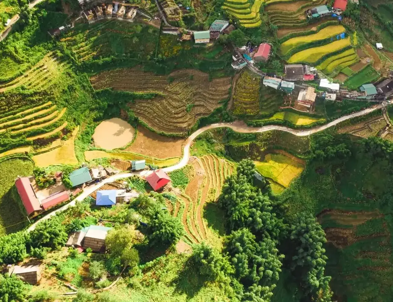
The Muong Hoa Valley, stretching 15 km (9 mi) southeast from Sapa town, is the primary trekking corridor. The Muong Hoa Stream, which translates loosely as Flower Stream, drains the valley and flows through a series of ethnic minority villages including Y Linh Ho, Lao Chai, Ta Van, and Giang Ta Chai. The valley walls are given over almost entirely to terraced rice cultivation: layer upon layer of flooded paddies at planting season, each terrace separated by the earthen bund walls that have been maintained by Hmong farming families for generations. The valley floor is broadly flat, but the trails connecting villages follow the contours of the terraces and involve constant small undulations that add up over a full day's walking.
The terrain of the Hoang Lien National Park, which covers 29,845 hectares centred on the Fansipan massif, is fundamentally different from the valley trekking environment. Below 1,800 m (5,906 ft), the forest is subtropical broad-leaf with bamboo, tree ferns, and dense undergrowth. Between 1,800 and 2,600 m (5,906 and 8,530 ft), the vegetation shifts to temperate montane forest: rhododendrons, magnolias, and a canopy that is frequently draped in cloud. Above 2,600 m (8,530 ft), the forest gives way to open subalpine scrub and rocky ridges. The trail to Fansipan passes through all three zones, which is part of what makes the ascent so varied despite its moderate length.
The Tram Ton Pass, also known as O Quy Ho Pass, crosses the Hoang Lien Son range at approximately 1,900 m (6,234 ft), making it the highest mountain road pass in Vietnam. It lies about 15 km (9 mi) west of Sapa town on the road toward Lai Chau Province. The pass is the starting point for the most popular Fansipan trekking route and is also remarkable in its own right as a viewpoint: on clear days, the descent on the Lai Chau side reveals a view of ridgelines extending west toward the Chinese border. The Silver Waterfall, a 200 m (656 ft) cascade visible from the road near the pass, is a standard stop on any motorised tour of the area.
The ancient rock carvings of the Muong Hoa Valley form a 8 sq km (3 sq mi) archaeological site containing around 200 large stones engraved with petroglyphs estimated to be approximately 2,000 years old. The carvings depict human figures, stilt houses, geometric patterns, and what appear to be solar symbols. The site has been on Vietnam's Tentative UNESCO World Heritage list since 1997. Individual carved stones are visible along the main valley trekking routes, particularly between Ta Van and Giang Ta Chai villages. A guide familiar with the valley will be able to identify the most significant stones; independent trekkers frequently walk past them without noticing.
History and Culture: Hmong, French, and the Mountains
The mountains around Sapa have been inhabited for at least two millennia, as the valley petroglyphs attest. The ethnic minority communities who live here today, principally the Hmong and the Red Dao, are relative newcomers by the standard of those carvings. The Black Hmong trace their presence in this specific area to migrations from southern China roughly three centuries ago, part of a broader pattern of Hmong movement southward from the Yellow River region of China following centuries of conflict with the Han Chinese. The Red Dao arrived in the 13th century from Hunan Province. The Tay and Giay people have a longer lowland Vietnamese presence that extends back further, occupying valley floors while the Hmong settled higher terrain. This vertical stratification of ethnic settlement, with different communities occupying different altitudinal zones, is characteristic of mountain societies across mainland Southeast Asia.
The French arrived in the late 19th century. Official surveys of the Lao Cai region began in 1898, and by 1901 a Black Hmong settlement known as Sa Pa had come to French colonial attention. The name derives from the Mandarin Chinese meaning sandy place, reflecting the earlier Chinese presence in the region. A military garrison was established in 1903, and the French developed the settlement as a hill station retreat from the lowland heat of Hanoi. By 1909, a formal hill station had been established; by the 1920s, Sapa had several hundred colonial villas, a church, a hotel, and a garrison. The Stone Church of Sa Pa, completed in 1930 and still standing on the town's central square, is the most visible remnant of this period.
The French left behind more than architecture. The road network that gives today's trekkers access to valley trailheads was built on colonial infrastructure. The railway connecting Hanoi to Lao Cai, which hikers use to reach the region today, was constructed between 1901 and 1906 by the French as part of the Yunnan Railway, intended to open southern China's interior to French commercial penetration. The line was built at enormous human cost: tens of thousands of Vietnamese labourers worked in brutal conditions, and mortality rates among the workforce during construction were high.
Nearly all of Sa Pa's colonial buildings were destroyed during the First Indochina War between 1946 and 1954, when the Viet Minh systematically denied French forces the use of occupied infrastructure. The town was largely abandoned and did not recover until the 1990s. In 1979, during the brief but brutal Sino-Vietnamese War, Chinese forces entered through the Lao Cai border crossing just below Sapa and advanced briefly into the surrounding area before being repelled. The border dispute that precipitated that conflict had been contested since the French-Chinese conventions of 1894 and 1896 that formally delimited the boundary. Sapa's proximity to China, today visible in the number of Chinese tourists and the Chinese-language signage in town, is a geographical and political reality that has shaped the area's history across multiple centuries.
International tourism to Sapa was permitted by the Vietnamese government from 1993. Visitor numbers grew from around 5,000 in 1995 to over 2 million by 2022. This growth has transformed Sapa town economically but has also created tensions that any visitor with honest eyes will notice: a poverty rate of around 28% among a population that is predominantly ethnic minority, alongside an expanding skyline of five-star hotel towers catering to a different economic order entirely. The question of how tourism revenue reaches the communities whose landscapes and cultures attract visitors, rather than pooling with lowland Vietnamese hotel developers, is one that responsible tour operators in Sapa navigate directly and that thoughtful hikers should engage with.
The Ethnic Minorities of Sapa
Understanding the ethnic communities of Sapa is not background reading for a trekking trip. It is the trekking trip. The trails of the Muong Hoa Valley pass directly through living villages. The homestays are in family homes. The guides are members of the same communities whose territory the hiker is moving through. Arriving with some knowledge of who you are meeting, rather than simply photographing the scenery they inhabit, is both respectful and practically rewarding: it enables conversations and observations that are closed to visitors who treat the valley as a backdrop.
The Black Hmong
The Black Hmong are the largest ethnic group in Sapa, comprising roughly 52% of the district population. They are distinguished by their clothing: deep indigo-dyed garments made from hemp fabric grown, processed, spun, woven, and dyed entirely within the community. The dyeing process uses indigo plants cultivated on field margins and produces a rich dark blue-black that transfers slightly to the hands of women who work with it daily, a characteristic observation on every valley trail. Black Hmong women are recognisable by their dark jackets, leg wraps, and embroidered accessories; men traditionally wear simpler black or dark blue clothing, though most men encountered in towns and on trails today dress in standard Vietnamese clothing.
Hmong society is organised around patrilineal clans. Marriage traditionally takes place within a limited set of permitted pairings between clans. The 'love market' tradition, in which young Hmong people from surrounding villages converged on Sapa on Saturday evenings to meet potential partners, was a genuine social institution before tourism commodified and ultimately absorbed it. Hmong spiritual practice combines animism, ancestor veneration, and shamanistic healing: household altars are present in every Hmong home, with specific offerings and protocols for different protective spirits. A respectful guest does not approach an altar without being invited to do so.
The Red Dao
The Red Dao are the second-largest ethnic group in Sapa, immediately recognisable by the women's elaborate red headdresses, from which their name derives, combined with heavily embroidered jackets and trousers in red, black, and silver. Red Dao communities occupy higher and more forested terrain than the Hmong, and the village of Ta Phin, approximately 12 km (7.5 mi) from Sapa town, is the most accessible Red Dao settlement for trekkers. The Red Dao are particularly known for their traditional herbal medicine knowledge: women gather medicinal plants from the forest and hillsides of the Hoang Lien Son range and use them in therapeutic herbal bath preparations that have become one of Sapa's most distinctive tourism experiences.
The Red Dao herbal bath involves soaking in a large hand-carved wooden barrel filled with water infused with a blend of foraged roots, bark, and leaves. Practitioners claim therapeutic effects including muscle recovery, skin conditions, and general circulation. Whether or not one accepts the specific medical claims, the experience of soaking in a mountain village in warm herb-infused water after a long day's trekking is one of Sapa's genuine pleasures and one of the more authentic commercial exchanges available to visitors. Herbal baths are available at Ta Phin village directly and at several Sapa-based spas that source herbs from Red Dao communities.
The Tay, Giay, and Xa Pho
The Tay people occupy valley floors along rivers and streams and are traditionally wet-rice farmers with a material culture closer to lowland Vietnamese than the highland Hmong or Dao. Ta Van village, at the far end of the classic Muong Hoa Valley trekking route, is a mixed settlement of Giay and Red Dao people. The Giay, also known as the Nhang or Yang, are a Tai-Kadai language group related to the Tay, and their village life in Ta Van provides a counterpoint to the Hmong settlements earlier on the same route. The Xa Pho, a small group of fewer than 10,000 people, live in higher forest settlements with limited contact with the trekking circuit. Their cotton textiles, featuring hill and water motifs, are among the finest traditional craft work in the Sapa region but are rarely encountered on standard routes.
Guided vs. Self-Guided Trekking in Sapa
The question of whether to trek with a guide in Sapa carries dimensions that go beyond route-finding. It is also a question of economics, cultural access, and ethical tourism practice. The answer depends on which trails you plan to walk, your comfort with navigation, and what kind of experience you are looking for.
The Case for a Guide
Hiring a local guide, particularly one from the ethnic minority communities whose villages the trail passes through, opens the experience in ways that independent walking cannot replicate. A Hmong guide walking her home valley will point out the petroglyphs that independent trekkers miss, explain the significance of what is growing in a particular field at a particular time of year, introduce you to family members at a homestay rather than leaving you as a paying stranger, and navigate the unmarked paths through bamboo forest and rice terrace margins that are straightforward to someone who has walked them since childhood and impenetrable to someone navigating by phone GPS for the first time. For the Fansipan ascent, a guide is legally required under Hoang Lien National Park regulations. For multi-day routes into less-visited areas, a guide is a practical safety necessity.
The most ethical way to hire a guide in Sapa is through a community-based operator that employs ethnic minority women and returns meaningful income to those communities. Sapa O'Chau is a Hmong-run social enterprise that arranges treks and homestays with local guides, reinvesting income in education and community development programs. Sapa Sisters is a women-owned and operated agency run by Hmong women, offering privately guided treks with homestays in guides' own family homes. Both operations charge more than a guide approached on the street, but the difference in experience and the directness of community benefit are significant. A trek with a guide who leads you to her village and introduces you to her family is a categorically different experience from a group tour with a lowland Vietnamese guide who translates but does not belong to the communities you are visiting.
Self-Guided Trekking
Independent trekking without a guide is legal and manageable on the main Muong Hoa Valley routes for experienced walkers with good navigation habits. The primary route from Sapa town through Cat Cat, Y Linh Ho, Lao Chai, and Ta Van is well-used by local farmers and, in peak season, busy with other hikers. Mobile signal is good across most of the open valley, and offline maps on Google Maps, Maps.me, or Gaia GPS show the village trails clearly. The path becomes less obvious in the bamboo forest sections and after rain, when paths through rice terraces can be narrow, slippery, and confused with agricultural access routes. Most wrong turns in the valley bring you to within 20 to 30 minutes of a village where locals can reorient you.
The honest limitation of self-guided trekking in Sapa is cultural rather than navigational. Walking through a Hmong village without a guide, you are a tourist passing through a living community. With a guide who belongs to that community, you are a guest. The difference in what you observe, understand, and are invited to participate in is substantial. For hikers whose priority is cultural depth rather than the physical achievement of the route, a guide is not optional equipment. For hikers who want physical exercise in beautiful scenery and are comfortable with limited cultural interaction, self-guided walking on the main valley routes is a perfectly reasonable choice.
A Note on Children Selling Goods
On the main tourist trails and in Sapa town, children from ethnic minority families sometimes approach hikers to sell woven bracelets, embroidered items, and other small crafts. These children miss school to do so. The consistent advice from community-based operators, teachers working in the valley villages, and responsible tourism advocates is clear: do not buy from children on the trail. The short-term transaction contributes to a cycle that keeps children out of school and teaches them that tourism works better than education as an economic strategy. If you want to buy ethnic minority crafts, buy from adult women in village markets or from community enterprise shops in Sapa town, where the income goes directly to the artisan.
PLANNING A HIKING HOLIDAY IN SAPA ?
Dive into our curated Sapa hiking adventures today!
Best Time for Hiking Sapa
September and October: Harvest Season
September and October are widely considered the best months for hiking in Sapa, and the reason is visual as much as meteorological. This is the rice harvest period: the terraces of the Muong Hoa Valley turn from green to gold, and the combination of ripe paddies, harvest activity, and the improved visibility that comes with the post-monsoon clearing of the air produces the conditions that generate most of the valley's iconic photography. Temperatures are comfortable for walking, typically 15 to 20°C (59 to 68°F) during the day, and trail conditions improve significantly after the monsoon season ends in August. Accommodation is in high demand from mid-September through October and should be booked well in advance, particularly for homestays in valley villages.
March to May: Spring and Planting
Spring is the second recommended season for hiking Sapa. The valley fills with water for the rice-planting season from March onward, and the terraces reflect sky and cloud in the flooded paddies, creating the mirror-like visual that is the other iconic Sapa image alongside the harvest gold. Temperatures are pleasant, wildflowers appear on the upper mountain terrain, and visitor numbers are lower than in autumn, making trail conditions less crowded and homestay availability more straightforward. March can still carry residual winter cold, particularly at night: temperatures in Sapa town can drop to 5°C (41°F) after dark in early March, and the Fansipan summit is regularly below freezing.
November to February: Winter and Cloud
Winter in Sapa runs from November through February and is the most atmospheric season for those who do not require clear views. The town sits in cloud for much of this period, with mist filling the valley and the mountains disappearing from sight. Temperatures in town drop to between 5 and 12°C (41 and 54°F) during the day and below zero at altitude. Snow falls on Fansipan's summit in most winters and has occasionally reached Sapa town itself, a rare event that generates enormous domestic tourism traffic from lowland Vietnamese cities. Trail conditions are wetter and muddier than other seasons, and accommodation with heating is essential. The upside: winter Sapa carries a dramatic, dreamlike quality, and the trails are at their least crowded.
June to August: Monsoon Season
The summer monsoon from June to August brings heavy rain, high humidity, and temperatures reaching 25°C (77°F) at valley level. Trail conditions deteriorate significantly: the clay soil of the rice terrace paths becomes dangerously slippery after rain, and sections of the Fansipan trail can become impassable in extended wet periods. Visibility on the mountains is poor. This is the least recommended season for trekking in Sapa, though it is manageable for hikers with appropriate waterproof equipment who are comfortable in mud. The valley is lush and green during this period, and rice cultivation is at its most active, which has its own visual interest.
Best Trails for Hiking in Sapa
Muong Hoa Valley: The Classic Route
The Muong Hoa Valley trek is the defining hike of Sapa and the route that most visitors come specifically to walk. The classic version runs approximately 10 to 14 km (6 to 9 mi) from the outskirts of Sapa town southeast through the villages of Cat Cat, Y Linh Ho, Lao Chai, Ta Van, and Giang Ta Chai, following the course of the Muong Hoa Stream. The trail descends from Sapa into the valley, passing through Black Hmong settlements and rice terraces in the upper section before flattening along the valley floor and passing through the Giay village of Ta Van and the Red Dao community of Giang Ta Chai. The Red Dao section involves a passage through bamboo forest to reach the village. Total elevation gain and loss is approximately 656 m (2,152 ft) across the day. The return to Sapa town is typically by motorbike taxi or vehicle hired at Ta Van or Giang Ta Chai.
The ancient rock carvings are found in the middle section of the valley, between Lao Chai and Ta Van, and are easy to miss without a guide pointing them out. At Lao Chai, a suspension bridge crosses the Muong Hoa Stream, providing good views up and down the valley. Near Giang Ta Chai, a waterfall accessible by a short detour provides a natural rest stop before the vehicle pickup. The trail is muddy and slippery after rain: appropriate footwear with grip is essential, and hiking poles significantly reduce the physical effort of descending wet terrace paths.
Quick Facts: Muong Hoa Valley Trek Distance: 10 to 14 km (6 to 9 mi) one way, depending on start point Duration: 5 to 7 hours walking Difficulty: Moderate; slippery in wet conditions Elevation Change: Approximately 656 m (2,152 ft) descent and re-ascent Best Season: September to October; March to May Start: Sapa town or Cat Cat Village (2 km / 1.2 mi from town centre) End: Giang Ta Chai or Ta Van; return by vehicle Highlights: Rice terraces, Black Hmong and Giay villages, ancient petroglyphs, suspension bridges, bamboo forest, Cau May Waterfall
Cat Cat Village: Half-Day Introduction
Cat Cat Village is the most accessible trekking destination from Sapa town: it sits just 2 km (1.2 mi) from the town centre, reachable in a 30 to 40 minute descent on a well-maintained stone-paved path. The village is a Black Hmong settlement and, being the most visited village in the Sapa area, the most commercially developed. An entry fee of around 70,000 VND is charged. Within Cat Cat, traditional crafts including weaving, dyeing, and silversmithing are on display, and a waterfall with a suspension bridge provides the natural centrepiece. The ascent back to town via the same path is the most physically demanding part of the route and takes most hikers around 40 to 50 minutes.
Cat Cat functions well as a half-day introduction to the valley landscape and Hmong village culture, though experienced travellers who have time for the full Muong Hoa Valley day will find it a more rewarding experience. Cat Cat is best visited early in the morning before tour group arrivals, or in the late afternoon when light is good for photography and visitor numbers have thinned.
Quick Facts: Cat Cat Village Distance: Approximately 4 km (2.5 mi) round trip from Sapa town Duration: 2 to 3 hours Difficulty: Easy to Moderate Entry Fee: Approximately 70,000 VND Best Season: Year-round; early morning for lower crowds Gateway: Sapa town centre Highlights: Black Hmong village, waterfall, weaving demonstrations, stone-paved descent through terraces
Ta Phin Village: Red Dao Territory
The trek to Ta Phin Village offers a quieter and culturally different experience from the Muong Hoa Valley routes. Located approximately 12 km (7.5 mi) from Sapa town to the northeast, Ta Phin is the primary Red Dao settlement accessible to trekkers and provides a clear contrast to the Black Hmong villages of the main valley. The women here wear the elaborate red headdresses and heavily embroidered clothing that make the Red Dao instantly recognisable; the village atmosphere is less commercial than Cat Cat and the craft production, particularly the embroidery work, is of exceptional quality. The route from town passes through rice fields, bamboo forest, and an old French-built cave, and takes four to five hours as a day trip at a moderate pace.
Ta Phin is also the main base for the Red Dao herbal bath experience. Baths are offered at several family-run facilities in and around the village, using herbs foraged from the surrounding Hoang Lien Son forest. After a day's walking, the therapeutic soak in a wooden barrel of warm herb-infused water is both physically restorative and culturally memorable. Arranging the herbal bath in combination with the Ta Phin trek through a community-based operator ensures that the income reaches Red Dao households directly.
Quick Facts: Ta Phin Village Distance: Approximately 12 km (7.5 mi) from Sapa town; full loop approximately 18 to 20 km / 11 to 12 mi Duration: 4 to 6 hours for full loop Difficulty: Moderate Best Season: September to October; March to May Gateway: Sapa town or direct transport to Ta Phin Highlights: Red Dao village, elaborate traditional costume, embroidery craft, French-era cave, herbal bath experience
Mount Fansipan: The Roof of Indochina
Fansipan, at 3,143 m (10,312 ft), is the highest peak in Vietnam and in all of Indochina, and reaching it is a different order of undertaking from the valley village treks. There are two ways to get there: on foot or by cable car. The cable car, operated by the Sunworld Fansipan Legend complex and inaugurated in 2016, holds the Guinness World Record for greatest elevation difference on a non-stop three-rope cable car. It covers 6.3 km (3.9 mi) and ascends 1,410 m (4,626 ft) in approximately 15 minutes, depositing passengers at a station below the summit from which around 600 steps and a funicular lead to the peak. Tickets cost around 800,000 VND (approximately $32) return. The cable car is accessible to all fitness levels and is a legitimate way to reach the summit if your goal is the view from the top rather than the physical challenge of the ascent.
The trekking route to Fansipan is a serious mountain undertaking. The most popular trail begins at the Tram Ton Pass trailhead, approximately 15 km (9 mi) from Sapa town by road, at an elevation of 1,900 m (6,234 ft). From here, the summit is 11.2 km (7 mi) distant. A fit, experienced hiker can complete the ascent in one hard day, seven to eight hours up from the trailhead, and then descend by cable car from the summit station. The more commonly recommended approach is a two-day trek with a basic mountain camp overnight at around 2,800 m (9,186 ft), which allows for a summit attempt before cable car crowds arrive in the morning. A guide is required under Hoang Lien National Park regulations and must be booked through a licensed operator. The trail involves steep forest terrain, some ladder and fixed-rope sections above 2,500 m (8,202 ft), and temperatures that can drop to well below freezing near the summit in any season. Cloud cover at summit level is frequent even on otherwise clear days.
Quick Facts: Mount Fansipan Trek Summit Altitude: 3,143 m (10,312 ft) Tram Ton Trailhead Altitude: 1,900 m (6,234 ft) Distance from Trailhead: 11.2 km (7 mi) to summit Duration: 1 day fast ascent with cable car descent; 2 days with mountain camp Difficulty: Challenging; guide mandatory Best Season: October to December; March to May; avoid monsoon June to August Gateway: Sapa town; Tram Ton Pass trailhead 15 km by road Highlights: Highest point in Vietnam and Indochina, three forest zones, ladder and rope sections, 360-degree summit views, Hoang Lien Son National Park biodiversity
Bac Ha Sunday Market
The Bac Ha Sunday Market, approximately 70 km (43 mi) from Sapa in a separate valley system of Lao Cai Province, is not a trekking route but deserves inclusion in any hiking itinerary as the most authentic ethnic market in the northern highlands. Held every Sunday, the market draws the Flower Hmong: a Hmong subgroup distinguished by their densely embroidered jackets and skirts in vivid multicolour floral patterns quite different from the dark indigo of the Black Hmong around Sapa. The market trades in livestock, vegetables, textiles, herbal medicines, and rice and corn wine. It is a functional commercial event rather than a tourism performance, and the atmosphere on a clear autumn Sunday morning, with hundreds of Flower Hmong women in full traditional dress arriving from surrounding villages, has no equivalent in the Sapa area itself. The drive from Sapa takes around two and a half hours each way, making it a full day trip.
Food and Drink in Sapa
The food culture of the Sapa mountains is shaped by altitude, ethnicity, and the seasonal rhythms of rice and corn cultivation. Meals in a homestay or a village family kitchen are almost entirely sourced from what grows on the surrounding terraces and hillsides: rice in its many forms, corn, pumpkin, mustard greens, foraged mountain vegetables, pork and chicken raised in the village, and fish from the streams. The cooking is simple, unhurried, and deeply satisfying in context. The most memorable food experience hiking Sapa offers is a meal eaten at a wooden table in a Hmong or Red Dao household after a full day on the trail.
Essential Dishes
Thang co is the signature dish of the Hmong people of the northern highlands and the most distinctive culinary landmark of the Sapa food scene. Traditionally made with horse or buffalo meat, bones, offal, and fat, it simmers for hours in a large iron pot with a blend of up to 20 mountain herbs and spices including cardamom, star anise, and cinnamon. The result is a rich, intensely savoury broth with a texture thickened by collagen from the bones and a herbal complexity that develops over the long cooking time. It is served communally at festivals and weekly at village markets. In Sapa town, a handful of dedicated Hmong restaurants serve it year-round. The correct accompaniment is ruou nguo, corn wine, which cuts through the richness.
Com lam, bamboo tube rice, is the most portable and widely available ethnic food in Sapa. Glutinous rice is packed into a green bamboo tube with water and a piece of banana leaf and roasted directly over charcoal until the rice is cooked through and the bamboo imparts a light smoky fragrance. The tube is split open to reveal the rice inside, which holds the cylindrical shape. It is sold by vendors at markets, trailside stalls, and village rest stops throughout the valley, served with grilled meat skewers, salted peanuts, or sesame salt. It is the ideal trail food: warm, filling, naturally packaged, and inexpensive. Men men is the everyday staple of Hmong households: dried corn ground to a coarse meal, mixed with water, and cooked in a pan until it forms a firm, slightly sweet porridge. It is the corn equivalent of ubugari or ugali and performs the same structural role at meals, scooped and dipped into soups and stews. It is rarely found on restaurant menus but appears at every shared homestay dinner table in Hmong territory.
Xoi ngu sac, five-colour sticky rice, is a specialty of the Tay people. Each colour is produced from a different natural plant dye: purple from magenta leaf, green from pandan, yellow from turmeric, red from gac fruit, with natural white as the fifth. It is served at celebrations and festivals but also sold as street food in Sapa market. The flavour is delicate, faintly herbal, and sweet, served with sesame salt.
Cap nach pig refers to the free-range black pigs raised by Hmong and Dao families, which forage on hillside terrain and are significantly leaner and more flavourful than commercially raised pork. Grilled over charcoal and served with mountain herbs and fresh chilli, it is the centrepiece of a serious homestay dinner and the benchmark against which all other pork in northern Vietnam is measured.
Mountain Drinks
Ruou nguo, corn wine, is the traditional alcoholic drink of the Hmong highlands: distilled from fermented corn, it is clear, strong, and warming, with a sweetness that reflects the corn base. It is present at every social occasion in the valley villages. A shared shot of corn wine at the start of a homestay dinner is a cultural gesture of welcome that should be accepted in the spirit it is offered. Ruou tao meo, an apple wine made from a small native mountain apple, is a milder and more fruity alternative available at village stalls and Sapa bars.
Vietnamese coffee, in the classic strong filtered drip style, is available throughout Sapa town and at the better-equipped homestay kitchens. The coffee culture in highland northern Vietnam is strong enough to survive the altitude. After a cold mountain morning, a glass of ca phe den, black filter coffee, served Vietnamese-style in a small glass with condensed milk on the side, is as good as breakfast gets.
The Red Dao Herbal Bath
The Red Dao herbal bath is not food but deserves mention alongside it as one of the most distinctive sensory experiences hiking Sapa offers. The bath uses water infused with a blend of herbs, roots, and bark foraged from the Hoang Lien Son mountain forests by Red Dao women who inherit their knowledge of medicinal plants through generations of family practice. The preparation simmers for several hours before the bather soaks for 20 to 30 minutes in a large wooden barrel. Regular users claim benefits for muscle recovery, skin conditions, and circulation. For a hiker at the end of a muddy valley day, the immediate effect is straightforwardly restorative. The experience is most authentic when arranged directly at Ta Phin Village or through a community-based operator that works with Red Dao families.
Accommodation for Hiking in Sapa
Sapa Town Hotels
Sapa town has undergone a hotel construction boom, and accommodation options at every price point are plentiful. The lower town area around Fansipan Street and Muong Hoa Street has the highest concentration of mid-range guesthouses and hotels, most with valley views from upper-floor rooms. Rates range from around $20 to $50 per night for mid-range options and exceed $200 per night at larger resort-style properties. Hotels with panoramic rice terrace views justify higher rates: on a clear morning, the view across the valley from a guesthouse terrace is the equal of anything the trail itself offers. Heating is an important consideration from November through March, and checking that rooms have functional warmth before booking is worthwhile.
Homestays in Valley Villages
Overnight homestays in the ethnic minority villages of the Muong Hoa Valley are the accommodation experience that distinguishes hiking Sapa from hiking anywhere else. Staying in a Hmong or Giay family home, eating meals cooked on a wood fire from village-grown ingredients, and waking to the view from a terrace that looks out over rice paddies rather than a hotel car park is the experience that most hikers who have done it describe as the highlight of the trip. Standards vary considerably: some homestay families have invested in basic Western amenities including flush toilets and warm showers; others are genuinely basic. Community-based operators including Sapa O'Chau and Sapa Sisters arrange homestays with member families where standards have been assessed and the income goes directly to the household. Rates for a homestay including dinner and breakfast typically range from around $15 to $35 per person.
Fansipan Mountain Camps
For trekkers doing the two-day Fansipan ascent, an overnight in a basic mountain camp at approximately 2,800 m (9,186 ft) is part of the itinerary. These camps provide simple shelter: a bunk or sleeping mat, a blanket, and a cook preparing hot food from supplies carried up from the trailhead. They are not comfortable in any conventional sense. At that altitude, in the mountain forest, in whatever weather the Hoang Lien Son is generating that night, they are exactly right. All licensed trekking operators who offer the two-day route include the camp accommodation in the tour price.
Planning and Logistics
Getting to Sapa
Sapa has no airport. The nearest international airport is Noi Bai International Airport in Hanoi, approximately 340 km (211 mi) to the southeast. From Hanoi, there are two standard approaches. The overnight sleeper train from Hanoi to Lao Cai takes eight to nine hours, arriving at Lao Cai station 40 km (25 mi) below Sapa in the valley. From Lao Cai, a bus or shared minivan makes the 45 to 60 minute ascent to Sapa town. Soft-berth four-person compartments on the train are comfortable and are the preferred option for most independent travellers. The overnight sleeper bus from Hanoi directly to Sapa takes five to six hours and arrives in Sapa town without the Lao Cai transfer, though road comfort is lower than the train. Day bus services are also available and take around five to six hours.
Getting Around
Within the Sapa trekking area, the primary transport options are on foot, by motorbike taxi, and by hired private vehicle. Motorbike taxis, locally known as xe om, are the standard way to get from trail endpoints back to Sapa town after a one-way valley trek. They are available at Ta Van, Giang Ta Chai, and most village endpoints and are inexpensive, typically 50,000 to 100,000 VND per person for a return to Sapa. For the Tram Ton Pass trailhead and other out-of-town starting points, a Grab or taxi from Sapa town costs around 150,000 to 200,000 VND. Private vehicle hire through your hotel or a local agency is the most flexible option for longer days combining multiple destinations.
Currency and Costs
Vietnam's currency is the dong (VND). ATMs are available in Sapa town. Cards are accepted at larger hotels and restaurants in town but not at village homestays, market stalls, or the trailside vendors who matter most. Carry sufficient cash for homestay payments, guide fees, entrance tickets, and motorbike taxis. A rough daily budget for trekking in Sapa, excluding accommodation, runs around 200,000 to 500,000 VND ($8 to $20) covering meals, water, and incidentals. A guided full-day Muong Hoa Valley trek costs around 350,000 to 1,000,000 VND ($15 to $40) per person depending on group size and operator. A two-day Fansipan guided trek costs approximately $135 to $145 USD per person.
Health and Safety
No vaccinations are specifically required for entry to Vietnam, but hepatitis A, typhoid, and tetanus are recommended by most travel health providers for northwest Vietnam. Malaria risk in Sapa town and at altitude in the Hoang Lien Son range is generally considered low by Vietnamese health authorities, though risk increases in forested and lowland border areas. Altitude sickness is a relevant concern for Fansipan trekkers: at 3,143 m (10,312 ft) the summit is high enough to cause symptoms in acclimatised visitors who ascend quickly. Spending one or two nights in Sapa town at 1,500 m (4,921 ft) before attempting the summit ascent provides meaningful acclimatisation. Trail safety on the valley routes is primarily a matter of appropriate footwear: the clay soil becomes extremely slippery after rain, and ankle support significantly reduces fall risk on wet terrace descents.
What to Pack
For day treks in the Muong Hoa Valley: waterproof hiking boots or trail shoes with grip, waterproof jacket, insulation layer for mornings and evenings, sunscreen, water (2 litres minimum), cash, and a phone with offline maps downloaded. For a Fansipan ascent: full waterproof shell, insulating mid-layer, fleece, warm hat and gloves, headtorch, trekking poles (significantly helpful on the steep and often wet trail), and sufficient food for the ascent if doing a one-day push. Your guide will carry emergency supplies and cooking equipment on a two-day trip. Do not plan for reliable mobile phone signal above the valley floor.
READY TO HIKE SAPA ?
Get started with your Hiking adventure now!
Frequently Asked Questions About Hiking in Sapa
Do I need a guide to trek in Sapa?
A guide is not legally required for the valley village routes including the Muong Hoa Valley and Ta Phin treks. For the Fansipan ascent, a licensed guide is mandatory under Hoang Lien National Park regulations. Even where not required, hiring an ethnic minority guide from a community-based operator significantly enriches the cultural experience and puts money directly into the villages you are walking through. Sapa O'Chau and Sapa Sisters are the recommended operators for community-benefit guided trekking.
What is the best one-day trek in Sapa?
The Muong Hoa Valley route from Sapa to Giang Ta Chai, passing through Y Linh Ho, Lao Chai, and Ta Van, is the best single-day trekking experience in Sapa. It covers 10 to 14 km (6 to 9 mi) of rice terrace and village terrain, passes the ancient petroglyphs, crosses suspension bridges over the Muong Hoa Stream, and ends at Cau May Waterfall before a motorbike taxi returns you to town. The route is best walked with a Black Hmong guide from a Sapa-based community operator.
How hard is the Fansipan hike?
The Fansipan one-day ascent via the Tram Ton Pass trail is a challenging undertaking: 11.2 km (7 mi) of steep, often muddy forest trail with approximately 1,240 m (4,068 ft) of elevation gain from the trailhead at 1,900 m (6,234 ft) to the summit at 3,143 m (10,312 ft). A good fitness level and hiking experience are required. The two-day version, camping overnight at 2,800 m (9,186 ft), is significantly more manageable. The cable car option requires no fitness at all but still involves 600 steps from the upper station to the true summit, which at altitude takes effort even for fit visitors.
When is the best time to see the golden rice terraces?
The golden rice harvest period peaks in mid-September through October. The exact timing varies by elevation: lower valley terraces ripen earlier than higher ones. The window for the most photogenic conditions is roughly mid-September to mid-October. At this time, trails are busy and accommodation books quickly; reserving homestays and hotel rooms at least two weeks ahead during this period is strongly recommended.
Can I trek independently without a guide?
Yes, for the main valley routes. The Muong Hoa Valley trail to Lao Chai and Ta Van is well-used and navigable with offline maps, particularly in dry conditions. The trail becomes significantly more challenging after rain, when paths through rice terraces become slippery and junctions are less clear. For the Fansipan ascent, a guide is required by park regulations. For routes beyond the main valley corridor, including longer multi-day treks into less-visited valleys, independent navigation becomes genuinely difficult and a guide is a practical necessity.
What should I know about interacting with ethnic minority communities?
The most important principle is respect for the fact that these are functioning villages, not cultural exhibits. Do not photograph people without asking permission. Do not enter a home without invitation. Do not buy from children on the trail. Remove shoes when entering a home if footwear is visible at the door. Accepting an offered drink or a small portion of food at a homestay is courteous and appreciated. Learning a few words of Hmong greeting is not expected but is always warmly received. Purchasing crafts directly from adult women artisans in the village, rather than from intermediary shops in Sapa town, is the most direct way to ensure that income reaches the community.
Is the Red Dao herbal bath worth doing?
Yes, particularly after a full day of valley trekking. The most authentic and community-beneficial version is arranged at Ta Phin Village or through Sapa O'Chau or a similar community-based operator. Herbal baths arranged at spas in Sapa town use Red Dao herbs but the income chain is less direct. The experience is genuinely restorative and distinctly local: soaking in a carved wooden barrel filled with mountain herb-infused water in a Red Dao village is not something available anywhere else.
How do I get from Hanoi to Sapa?
The overnight sleeper train from Hanoi to Lao Cai followed by a 45 to 60 minute minivan to Sapa is the recommended route. Trains depart Hanoi in the evening and arrive at Lao Cai early morning, giving a full first day in the valley. Book train tickets through Vietnam Railways' official online platform or through a reputable tour operator. Soft-berth four-person compartments are comfortable and significantly better than hard berths for an overnight journey.
Plan Your Hiking Trip to Sapa
Hiking in Sapa rewards preparation but forgives imperfection in the way that beautiful places tend to. The trails are not long or technically demanding by the standards of other destinations in this series. What they require is curiosity: about the communities you are walking through, the agricultural systems that produce the landscape you have come to see, and the practical questions of how your visit connects with rather than merely extracts from the people who live here. A morning of mist over the Muong Hoa Valley from the terrace of a Hmong homestay, a bowl of thang co in a market kitchen, a summit view from Fansipan earned on foot: these are the coordinates of a hiking experience with no equivalent anywhere in Southeast Asia.
Explore our guided hiking journeys at Art of Bicycle Trips.
Plan Your Active Adventure
Create a private trip or join a small-group departure.
