Overview
The Pekoe Trail, winding through Sri Lanka’s central highlands, is the country’s first long-distance hiking route and a journey into the heart of its tea country. Stretching for more than 300 kilometers, the trail follows old plantation roads and footpaths carved during the colonial era, linking mountain ridges, forest reserves, and villages shaped by the rhythms of tea. Today, it offers travelers one of the most immersive ways to experience Sri Lanka’s landscapes and heritage on foot.
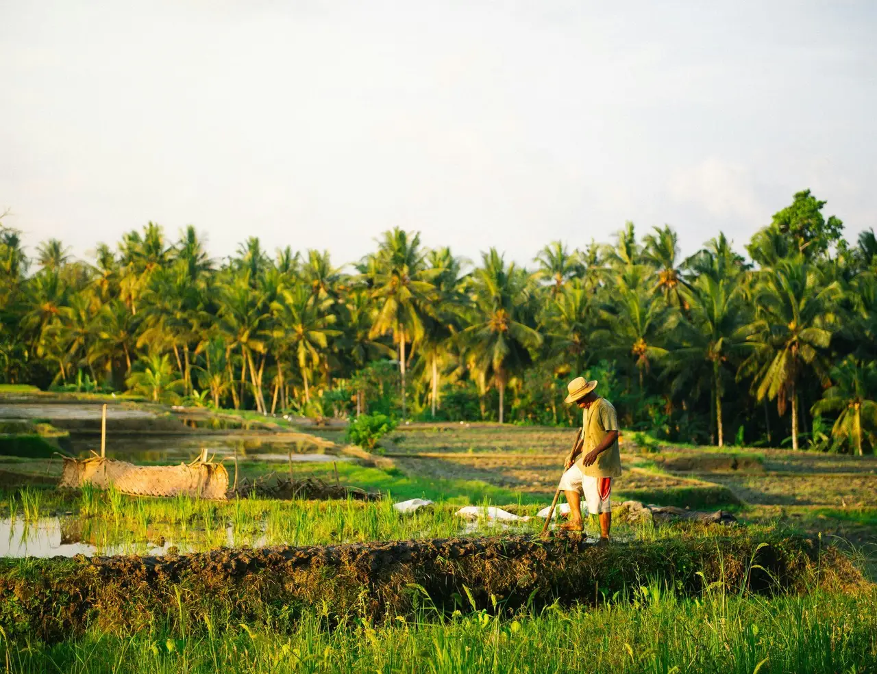
The path meanders past rows of emerald-green tea bushes, misty valleys, cascading waterfalls, and forested ridgelines where the air carries the scent of eucalyptus and wildflowers. In the early morning, clouds drift low over the hills; by afternoon, light spills across terraced slopes and quiet estate towns. Along the way, tea pickers move rhythmically through the fields, and rural life unfolds in small markets, temples, and roadside tea stalls that welcome passing walkers.
Hikers often choose sections around Haputale, Ella, or Horton Plains, where scenery shifts dramatically from rugged mountains to cloud forests alive with bird calls. But the broader route stretches across 22 stages, offering options for both short day walks and multi-day treks that connect remote villages with larger towns. Each stage reveals another layer of Sri Lanka’s highlands: colonial-era bungalows hidden among tea fields, Buddhist shrines on windswept ridges, and homestays where travelers share meals of rice, curry, and sweet milk tea.
Walking the Pekoe Trail is as much about cultural encounters as natural beauty. Local guides share stories of the land, hosts open their homes to hikers, and the trail itself is designed to bring economic benefit to rural communities. It is a route that celebrates both resilience and hospitality, inviting travelers into a landscape that feels timeless yet alive with human history. Whether you are drawn to the rolling tea estates, the serenity of forested hills, or the chance to step into the daily rhythm of Sri Lankan village life, hiking the Pekoe Trail offers a journey where nature, culture, and tradition are inseparable.
DREAMING OF HIKING IN THE PEKOE TRAIL ?
Explore our amazing hiking tours in The Pekoe Trail now !
Location
The Pekoe Trail is defined by misty mountains, rolling tea estates, and cool upland forests. Stretching for more than 300 kilometers across 22 stages, it winds through the districts of Kandy, Nuwara Eliya, Badulla, and Ella, linking some of the country’s most iconic hill-country towns with smaller villages tucked into valleys and ridges.
The most popular hiking stretches lie around Haputale, Ella, and Nuwara Eliya, where dramatic scenery combines with easy access to transport and lodging. Here, elevations rise from 1,000 to over 2,000 meters, offering hikers crisp mountain air, sweeping views of terraced slopes, and cooler climates that contrast with the tropical lowlands below. The Horton Plains plateau, home to the famous World’s End escarpment, adds an alpine-like landscape of grasslands and cloud forests to the mix, while places like Haputale and Bandarawela showcase wide horizons over tea-carpeted valleys.
The geography of the Pekoe Trail is inseparable from its history. Old plantation tracks, forest paths, and estate roads form much of the route, threading past rivers, waterfalls, and ridgelines that once carried workers and traders between tea estates and towns. Along the way, hikers encounter colonial-era bungalows, Hindu temples, Buddhist shrines, and small market squares that root the trail deeply in both cultural and natural heritage.
Many of the towns and villages along the Pekoe Trail have retained their charm: tea factories with red-brick facades, roadside stalls selling milk tea and short eats, and homestays that welcome travelers into daily life. Unlike remote wilderness treks, the Pekoe Trail keeps you close to communities, creating a rhythm where human warmth and mountain scenery go hand in hand. Reaching the trail is straightforward thanks to Sri Lanka’s network of rail and road connections. Scenic trains link Colombo with Kandy, Nuwara Eliya, Haputale, and Ella, placing hikers within easy reach of starting points. Buses and local taxis connect smaller towns, ensuring that each stage is accessible. Despite its remote feel in places, the Pekoe Trail remains well connected to modern conveniences, making it an inviting introduction to long-distance hiking in Sri Lanka.
Getting There
The Pekoe Trail runs through the hill country of central Sri Lanka, linking historic towns like Kandy, Nuwara Eliya, Haputale, Bandarawela, and Ella with smaller villages and tea estates along the way. Today, the most popular sections for hiking the Pekoe Trail lie around Ella, Nuwara Eliya, and Haputale, where dramatic scenery meets excellent transport links and a range of lodging options. These stretches are easy to access, making the trail welcoming even for first-time visitors to Sri Lanka.
Because the Pekoe Trail follows estate paths and mountain ridges across the central highlands, access tends to concentrate in a few well-connected hubs. Kandy serves as the main entry point for stages in the northern section, while Nuwara Eliya and Haputale connect to trails running through tea-carpeted valleys. Ella, with its lively traveler scene and scenic railway, is another convenient base for hikers planning multi-day walks. From these towns, local buses, tuk-tuks, and even estate jeeps connect directly to trailheads and villages along the route.
By Air
The nearest international airport is Bandaranaike International Airport in Colombo, Sri Lanka’s main gateway. From here, it takes around 3–4 hours by car or train to reach Kandy, the traditional starting point of the Pekoe Trail. Domestic flights are also available to Nuwara Eliya via the small airport at Katugastota, though most travelers prefer the scenic journey by rail or road through the highlands.
By Rail
Sri Lanka’s central highlands are famous for their railway, often called one of the most scenic train journeys in the world. The main Colombo–Badulla line passes directly through Kandy, Nuwara Eliya (via Nanu Oya), Haputale, Bandarawela, and Ella, making it the perfect way to reach multiple sections of the Pekoe Trail. The ride itself, with sweeping views over tea plantations and viaducts like the Nine Arches Bridge, is part of the hiking experience. Trains can be busy, so booking in advance is recommended.
By Bus and Road
A network of intercity buses and private vans connects Colombo and other lowland towns with the hill country. Buses run frequently to Kandy, Nuwara Eliya, and Badulla, from where local connections continue into smaller towns and villages. While buses are affordable and widely used, many hikers opt for private cars or tuk-tuks to reach more remote trailheads. Road travel is slower than the distance might suggest, but the winding mountain roads offer spectacular views.
Kandy, Ella, and Nuwara Eliya are lively towns in their own right, with bustling markets, colonial architecture, and guesthouses that serve as practical bases. From these hubs, the journey quickly shifts from urban bustle into the cool air of the tea country, where the trail winds through plantations, forests, and ridges that have defined the highlands for centuries.
The Pekoe Trail Etymology and History
The name “Pekoe Trail” comes from the term pekoe, a grade of black tea used in the international tea trade. The word itself is believed to have originated from the Chinese bai hao (“white hair”), referring to the fine silvery tips of young tea leaves. By adopting the name, the trail links itself directly to the history and global story of Ceylon tea, the product that shaped the Sri Lankan highlands and connected the island to the wider world.
Historically, the central highlands of Sri Lanka were transformed in the 19th century under British colonial rule. After a devastating blight wiped out the island’s coffee plantations, planters turned to tea. Estates spread quickly across the hills, reshaping forests into rolling carpets of green. Paths and bridle roads were cut into the landscape so that workers, traders, and colonial managers could move between estates, factories, and railway stations. Many of the routes now woven into the Pekoe Trail trace their origins back to these estate roads and workers’ footpaths.
The trail stretches for more than 300 kilometers, passing through the heart of tea country, from Kandy in the north to Nuwara Eliya, Haputale, and Ella further south. Along the way it connects small villages, bustling market towns, and estates that still operate much as they did over a century ago. Walking these routes reveals the layered history of the highlands: colonial bungalows, Hindu kovils and Buddhist temples, Tamil and Sinhalese villages, and railway lines that once carried Ceylon tea to Colombo and the world beyond.
The Pekoe Trail is also a story of resilience and identity. Generations of Tamil tea estate workers, originally brought from South India under British rule, built their lives in these highlands. Today, their communities remain central to the culture and economy of the tea country. By opening their homes as guesthouses and sharing food, music, and traditions, they bring the social history of the plantations into the hiking experience.
In many ways, the Pekoe Trail is both a heritage corridor and a modern initiative. Supported by local communities, conservationists, and international partners, it aims to preserve estate landscapes while creating sustainable tourism that benefits those who live along the route. Hikers not only cross ridges and valleys but also trace the footsteps of planters, laborers, and traders whose lives were tied to the global story of tea.
Today, walking the Pekoe Trail is a way of entering Sri Lanka’s living history. Its name recalls the world-famous leaf that reshaped the island’s highlands, while its paths reveal the colonial, local, and global cultural details that continue to define this remarkable landscape.
Best Time for Hiking in the Pekoe Trail
With elevations between 1,000 and 2,000 meters across Sri Lanka’s central highlands, the Pekoe Trail enjoys a cooler and more temperate climate than the tropical lowlands. While it can be walked year-round, hikers will find the most rewarding experiences during the drier inter-monsoon periods, when the skies are clearer, paths are firmer underfoot, and the rolling tea estates show off their most vibrant shades of green.
Best Seasons – January to April and June to September
January to April
This is one of the most popular times to hike the Pekoe Trail, as the northeast monsoon fades and the weather turns bright and stable. Days are pleasantly warm, averaging between 18°C and 25°C (64°F to 77°F) in the highlands, while nights can be cool enough for a light sweater. Tea plantations are lush after the rains, streams run full, and the skies are crisp, making it a perfect season for long-distance walking and photography. Many cultural festivals also fall during this period, adding lively color to village life along the trail.
June to September
The southwest monsoon largely affects Sri Lanka’s western and southern coasts, leaving the central highlands relatively sheltered. This makes mid-year another excellent season for hiking. Expect misty mornings that lift into sunny afternoons, cool breezes across the ridges, and landscapes that range from freshly pruned tea bushes to valleys dotted with wildflowers. Temperatures remain comfortable, generally 17°C to 24°C (62°F to 75°F). The trails are quieter at this time of year, making it a great option for those seeking solitude.
Shoulder Seasons – October to December and May
May
May marks the shift from dry to wet, with higher humidity and the chance of afternoon showers. While it is still possible to walk sections of the trail, conditions can feel heavier, and the tea fields are often veiled in mist. For those who enjoy moody landscapes and fewer fellow hikers, May can hold a special charm, though it requires flexibility and good rain gear.
October to December
The northeast monsoon brings heavier rains to the highlands during these months. Trails may be slippery, river crossings fuller, and leeches more common in damp forests. Still, the rain breathes life into the landscape, filling waterfalls and cloaking the tea hills in vivid green. For experienced hikers prepared for wet-weather conditions, this season offers a different, more atmospheric side of the Pekoe Trail.
PLANNING A HIKING HOLIDAY IN SRI LANKA?
Dive into our curated Sri Lanka hiking adventures today!
Which Are the Best Routes for Hiking the Pekoe Trail?
The Pekoe Trail runs for nearly 300 kilometers, connecting Kandy to Nuwara Eliya, Ella, and beyond. Designed as a long-distance hiking network, the trail is divided into 22 stages, each revealing a different facet of the island’s tea country. While the entire route can be walked over several weeks, most visitors choose shorter sections that combine plantation landscapes, forest trails, colonial history, and local encounters. Here are some of the most rewarding stages for hiking the Pekoe Trail:
1. Stage 1: Kandy to Galaha
The journey begins in Kandy, Sri Lanka’s cultural capital, before leading into the rolling hills of tea country. The trail quickly shifts from the bustle of city life to quiet paths lined with pepper vines, spice gardens, and tea estates first planted in the 19th century. Views open up over the Mahaweli River valley, offering a gentle but scenic start. Along the way, the scent of cinnamon and cardamom drifts from small homesteads, reminding hikers of Sri Lanka’s spice heritage.
Quick Facts
Distance: ~12 km (7.5 mi) Time Needed: 4–5 hours Difficulty Level: Easy to Moderate Highlights: Kandy’s cultural heritage, spice gardens, early tea plantations, views over river valleys
2. Stage 6: Pidurutalagala Foothills
One of the trail’s most dramatic stages, this section skirts the lower slopes of Pidurutalagala, Sri Lanka’s highest peak. The hike passes pine forests, mist-laden eucalyptus groves, and remote tea hamlets, with cool highland air making for comfortable walking. On clear days, panoramic views stretch toward Nuwara Eliya, often called “Little England” for its colonial-era bungalows and gardens. Early mornings here are especially atmospheric, with mist rising over terraced fields and dew glistening on tea bushes.
Quick Facts
Distance: ~15 km (9 mi) Time Needed: 5–6 hours Difficulty Level: Moderate Highlights: Views of Pidurutalagala, eucalyptus and pine forests, tea estate villages, proximity to Nuwara Eliya
3. Stage 10: Haputale to St. Catherine’s Seat
This is one of the most celebrated stretches of the Pekoe Trail, weaving through the iconic Lipton’s Seat region. Trails cut across lush tea estates planted under the guidance of Sir Thomas Lipton himself, with lookouts offering sweeping views of the southern plains. The walk is both scenic and cultural, passing estate communities whose families have worked the plantations for generations. Brightly dressed tea pluckers are a common sight here, their baskets filled with fresh green leaves that fuel Sri Lanka’s world-famous brew.
Quick Facts
Distance: ~14 km (8.5 mi) Time Needed: 5 hours Difficulty Level: Moderate Highlights: Lipton’s Seat viewpoint, historic tea estates, cultural encounters with estate workers
4. Stage 12: Haputale to Ohiya
A classic highland route, this stage climbs through forested ridges and open grasslands toward Ohiya, a gateway to Horton Plains National Park. The terrain is varied, shifting between shaded jungle trails and ridgelines with long views. For many hikers, this stage captures the wild, less-traveled beauty of the central mountains. The call of junglefowl and the rustle of monkeys in the canopy often accompany hikers as they move deeper into these forests.
Quick Facts
Distance: ~16 km (10 mi) Time Needed: 6 hours Difficulty Level: Moderate to Strenuous Highlights: Highland ridges, forest paths, wildlife encounters, access to Horton Plains
5. Stage 16: Nuwara Eliya to Thalawakelle
This stage highlights the colonial legacy of tea country, linking the cool-climate town of Nuwara Eliya with Thalawakelle’s thriving estates. Trails run past Gregory Lake, flower gardens, and undulating plantations dotted with factories that still process tea leaves using century-old machinery. Steam rising from tea factories and the clatter of withering machines give a tangible sense of how the region’s economy and identity remain tied to tea.
Quick Facts
Distance: ~13 km (8 mi) Time Needed: 4–5 hours Difficulty Level: Easy to Moderate Highlights: Nuwara Eliya town, Gregory Lake, colonial tea factories, panoramic plantations
6. Stage 20: Bandarawela to Ella
Among the most popular parts of the Pekoe Trail, this section leads toward Ella, one of Sri Lanka’s best-known hill-country towns. The hike takes in dramatic viewpoints like Ella Rock and Little Adam’s Peak, with the famed Nine Arches Bridge often appearing as a highlight. Ending in Ella allows hikers to enjoy a lively mix of cafes, guesthouses, and yoga retreats. Trains occasionally rumble across the Nine Arches Bridge as hikers watch from the trail, adding a memorable flourish to the day.
Quick Facts
Distance: ~14 km (8.5 mi) Time Needed: 5–6 hours Difficulty Level: Moderate Highlights: Ella Rock, Little Adam’s Peak, Nine Arches Bridge, vibrant hill-country town life
7. Full Pekoe Trail (Kandy to Ella and beyond)
For those with more time, the entire 300 km trail can be walked in about 3 to 4 weeks. This long-distance journey links all 22 stages, creating a complete picture of Sri Lanka’s central highlands. It is the most immersive way to experience tea country, combining plantation history, diverse landscapes, and deep cultural encounters across dozens of towns and villages. Completing the full route means not only seeing the highlights but also walking through remote corners where few tourists go, encountering daily rhythms of tea country life.
Quick Facts
Distance: ~300 km (186 mi) Time Needed: 22 days (average 1 stage per day) Difficulty Level: Moderate overall, with some strenuous sections Highlights: Full immersion into tea landscapes, local communities, cultural and natural diversity, colonial history
Accommodation Options on the Pekoe Trail Hiking Trail
One of the unique joys of hiking the Pekoe Trail is the chance to stay in the heart of Sri Lanka’s tea country. Instead of remote mountain huts, the trail passes through bustling towns, historic estates, and small villages, which means hikers can rest each night in comfort while experiencing the culture of the central highlands. Options range from simple homestays with plantation families to elegant colonial-era bungalows built by British planters in the 19th century. Meals often feature rice and curry, fresh vegetables from the hills, and, of course, plenty of Ceylon tea served straight from nearby estates.
Unlike alpine treks, accommodation on the Pekoe Trail is rooted in the living culture of tea country. Estate towns and villages along the route provide easy access to stays, making it possible to hike with a light pack and plan multi-day journeys without worrying about carrying camping gear. Larger towns such as Kandy, Nuwara Eliya, Haputale, and Ella offer modern hotels and guesthouses, while rural stages introduce hikers to stilted farmhouses, eco-lodges, and estate bungalows.
Here are some of the main accommodation highlights along the most popular stretches of the Pekoe Trail:
1. Kandy to Galaha
Starting in Sri Lanka’s cultural capital, accommodation options are plentiful. Hikers can choose between boutique guesthouses near Kandy Lake or family-run homestays as they leave the city behind. In Galaha, simple village lodgings provide warm hospitality, with home-cooked meals that introduce visitors to the flavors of Kandyan cuisine.
Accommodation highlights: Boutique guesthouses in Kandy, homestays in Galaha with family-style dining, eco-lodges overlooking spice gardens.
2. Pidurutalagala Foothills (near Nuwara Eliya)
Nuwara Eliya, often called “Little England,” is one of the most atmospheric bases on the trail. Its colonial-era hotels, tea-planter bungalows, and garden cottages reflect the legacy of the British tea industry. Outside the town, smaller guesthouses and eco-lodges on estate lands offer quieter alternatives with views of misty hills.
Accommodation highlights: Colonial tea bungalows, heritage hotels in Nuwara Eliya, eco-lodges in nearby plantations.
3. Haputale and Lipton’s Seat
Haputale is famous for its tea heritage, and many plantation bungalows have been restored as guest accommodations. Staying here allows hikers to experience life on a working tea estate, complete with manicured gardens and panoramic verandas. In nearby villages, budget guesthouses and homestays offer an authentic connection to estate communities.
Accommodation highlights: Restored colonial tea bungalows, mid-range guesthouses with sweeping valley views, local homestays near Lipton’s Seat.
4. Haputale to Ohiya
This stage, close to Horton Plains, has more rustic accommodation. Ohiya is a small hamlet with simple guesthouses and homestays, often run by families who prepare hearty Sri Lankan meals for hikers. These lodgings provide an intimate atmosphere and easy access to Horton Plains National Park the following morning.
Accommodation highlights: Family-run guesthouses in Ohiya, rustic homestays with traditional meals, small inns on the edge of Horton Plains.
5. Nuwara Eliya to Thalawakelle
This stretch is particularly rich in estate stays. Tea factory bungalows, some dating back over a century, have been converted into boutique lodges that combine heritage with modern comfort. Staying in these bungalows offers a rare chance to step into the colonial history of Sri Lanka’s tea industry.
Accommodation highlights: Tea estate bungalows with historic charm, boutique plantation lodges, hotels in Thalawakelle town.
6. Bandarawela to Ella
This is one of the most popular stretches of the Pekoe Trail, and accommodation options are abundant. In Ella, hikers will find everything from backpacker hostels and yoga retreats to stylish boutique resorts perched on cliffsides. Many offer easy access to Ella Rock, Little Adam’s Peak, and the iconic Nine Arches Bridge.
Accommodation highlights: Guesthouses with views of Ella Rock, eco-lodges near tea plantations, boutique hotels with modern amenities.
7. Multi-Day Full Route (Kandy to Ella and beyond)
For hikers completing longer sections, accommodations can be linked stage by stage, from homestays in villages to heritage bungalows in the estates. Each overnight stay adds to the journey, offering different insights into tea culture, from conversations with estate workers to afternoons spent on bungalow verandas sipping freshly brewed Ceylon tea. Advance bookings are highly recommended during peak seasons from December to April and July to September.
Accommodation highlights: Homestays with plantation families, restored tea bungalows, eco-lodges in remote valleys, hotels in major towns like Kandy and Nuwara Eliya.
Whether you choose the simplicity of a village homestay, the comfort of a guesthouse, or the elegance of a colonial tea bungalow, accommodations on the Pekoe Trail are as much a part of the experience as the walking itself. Staying overnight in Sri Lanka’s hill country offers not only rest but also a window into the daily life, history, and hospitality of the island’s tea-growing heart.
Frequently Asked Questions
Do I need a map or GPS to navigate the trail?
The Pekoe Trail is waymarked in most stages, but signage can be inconsistent in certain stretches, especially in remote valleys or during misty weather. To avoid confusion, hikers are strongly encouraged to use the official Pekoe Trail app or download GPS files from platforms like Wikiloc or AllTrails. These tools act as reliable backups and help ensure you stay on track, particularly in sections where paths branch off into tea plantations or forests.
Is the Pekoe Trail open year-round?
The trail is officially open throughout the year, but conditions vary significantly by season. The most favorable months for hiking are December to April and July to September, when rainfall is lower and paths are safer. During the monsoon periods, some stages can become muddy, slippery, or fog-covered, which reduces visibility and makes navigation more challenging. Planning around these weather windows ensures a more comfortable and rewarding hike.
Is there mobile network coverage along the Pekoe Trail?
Network coverage is generally good near towns, roads, and estate villages, but hikers should expect patchy or no signal in dense forest sections and remote valleys. To stay prepared, download offline maps and save waypoints before setting out. Having a GPS-enabled app not only aids navigation but also provides peace of mind in areas where connectivity drops.
Are there wild animals or safety risks I should watch for?
The trail does not pose major wildlife dangers, but hikers frequently report leeches during the wet season and slippery terrain in humid or rainy conditions. Some stretches pass close to estate lands or forest edges, so it is best to stay on marked paths and avoid wandering off-trail. As with most long-distance routes, hiking during daylight hours and keeping essentials like repellent and a first-aid kit on hand adds an extra layer of safety.
READY TO HIKE THE PEKOE TRAIL?
Get started with your Hiking adventure now!
Plan Your Active Adventure
Create a private trip or join a small-group departure.
