Table of Contents
- 1. Overview
- 2. Geography of Hiking in Lombardy
- 3. History and Culture: Lombards, Silk, and the Mountains
- 4. The Rifugio: Lombardy's Mountain Hut Culture
- 5. Best Time for Hiking Lombardy
- 6. Best Trails for Hiking in Lombardy
- 7. Food and Drink in Lombardy
- 8. Accommodation for Hiking in Lombardy
- 9. Planning and Logistics
- 10. Frequently Asked Questions About Hiking in Lombardy
Overview
Hiking in Lombardy is a study in contrast that no other Italian region replicates. Within a single day's journey from Milan, a hiker can walk the eastern shore of Lake Como along a Roman trade route threading through olive groves and chestnut woods, ascend to a rifugio perched above glaciers in the Valmalenco, or traverse the Sacro Monte of Varese through a sequence of 14 UNESCO-listed chapels on a wooded hillside above Lake Maggiore. Lombardy is the most economically productive region in Italy, home to its wealthiest city and its densest industrial corridor, yet it contains some of the most intact alpine territory in the central Alps, including the Italian section of Stelvio National Park, the largest national park in the Alpine arc.
What makes hiking Lombardy distinct from hiking elsewhere in Italy is the extraordinary vertical range compressed into the region's northern third. Lake Como sits at 197 m (646 ft) above sea level. Pizzo Bernina, the highest peak in the entire Eastern Alps, rises to 4,049 m (13,284 ft) in the Valmalenco above Sondrio, a straight-line distance of approximately 90 km (56 mi) from the lake. Between these extremes, the terrain accumulates everything that makes northern Italian mountain hiking distinctive: the lakeside paths above Como and Maggiore with their subtropical vegetation and painted villages; the terraced Nebbiolo vineyards of the Valtellina running along the entire south-facing flank of the Alpine spine from Colico to Bormio; the Orobie Bergamasche, a compact range of peaks and valleys between Bergamo and the Swiss border; the high Valmalenco with its glacier approaches and CAI rifugi; and the Stelvio massif with its 4,000 m Ortler group.
The hiking infrastructure of Lombardy is built around the network of the Club Alpino Italiano, which maintains trail waymarks, publishes route guides, and operates or subsidises the rifugi that make multi-day alpine itineraries possible. Italian trail waymarking uses the CAI system of red-and-white horizontal stripes on rock faces and trees, combined with numbered route signage that links to local CAI section maps. The Lombardy section of the CAI covers 22 provincial sections and thousands of waymarked kilometres. The Sentiero Italia CAI, the world's longest hiking route at approximately 7,000 km (4,350 mi), crosses the entire country and passes through the Lombard Alps, connecting the Valtellina to the wider national network.
This guide covers the geography, historical context, the Italian rifugio culture, the best seasons, the principal hiking zones and trails, the food culture, accommodation, and practical logistics for hiking in Lombardy from a gentle lakeside morning walk to a multi-day high-alpine traverse.
DREAMING OF HIKING THE LOMBARDY ?
Explore our amazing hiking tours in Lombardy now!
Geography of Hiking in Lombardy
Lombardy covers 23,844 sq km (9,206 sq mi) and divides broadly into three horizontal bands of landscape from south to north: the Po Plain, the Pre-Alps and lake district, and the central Alps. The Po Plain, covering the southern half of the region, is intensively farmed and urbanised and provides the context rather than the destination for hikers. The Pre-Alps, stretching from Varese in the west through the Brianza and Bergamasque hills to Lake Garda in the east, provide accessible, well-connected hiking at moderate elevations between 300 and 1,500 m (984 and 4,921 ft). The central Alps, comprising the Valtellina, Valmalenco, Val Camonica, and the Stelvio massif, constitute Lombardy's most demanding and most rewarding hiking environment.
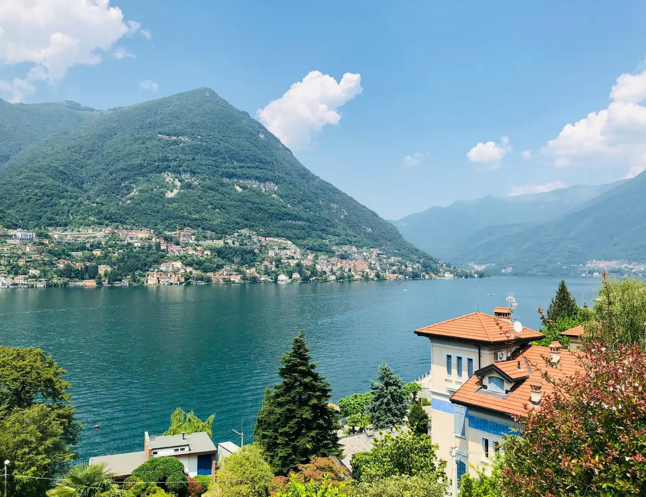
The lake district is the defining visual element of western Lombardy for international visitors. Lake Como, the deepest lake in Italy at 425 m (1,394 ft), occupies an inverted-Y shaped basin 46 km (29 mi) long in the provinces of Como and Lecco. Its eastern arm, the Ramo di Lecco, is the starting point for the Sentiero del Viandante and the most accessible hiking on the lake. Lake Maggiore straddles the Lombardy-Piedmont border and extends into Switzerland at its northern end; its eastern shore falls within the province of Varese, providing access to the Sacro Monte di Varese and the Campo dei Fiori nature reserve. Lake Iseo, the most overlooked of the major Lombard lakes, sits between Brescia and Bergamo provinces and is bordered on three sides by the Franciacorta wine hills and the Bergamasque Alps.
The Valtellina is Lombardy's longest alpine valley, extending 130 km (81 mi) from Colico at the northern tip of Lake Como to Bormio and Alta Valtellina near the Swiss and Austrian borders. The valley runs broadly east-west, draining through the Adda River into Lake Como. The south-facing Rhaetian slopes above the valley floor carry the Nebbiolo vine terraces of Valtellina Superiore DOCG; the north-facing Orobie Alps on the opposite side form the Orobie Valtellinesi Regional Park. The lateral valleys running south into the Orobie, including the Val Gerola, Val Masino, and Val di Mello, contain some of the most dramatic granite scenery in the Alps.
Valmalenco, the most important lateral valley of the Valtellina for high-alpine hiking, runs north from Sondrio into the Bernina massif. Its head valley above Chiareggio abuts the glaciers of Monte Disgrazia at 3,678 m (12,067 ft), the southernmost independent 3,000 m peak in the Alps, and Pizzo Bernina at 4,049 m (13,284 ft), the highest point in the Eastern Alps. The valley contains a dense network of rifugi connected by the Alta Via della Valmalenco, an eight-stage, 110 km (68 mi) high-altitude route at an average elevation of approximately 2,000 m (6,562 ft).
Stelvio National Park, covering 134,620 hectares across Lombardy, Trentino, and South Tyrol, contains the Italian section of the Ortler-Cevedale mountain group. The Stelvio Pass road at 2,758 m (9,048 ft), the highest paved mountain pass in Italy, provides vehicle access to trailheads above 2,500 m (8,202 ft) and is the starting point for several glacier approach trails. The park's Lombard section hosts ibex, chamois, red deer, marmots, and the occasional wolf in a protected corridor that extends from the valley floor at Bormio to the summit glaciers of the Ortler group.
History and Culture: Lombards, Silk, and the Mountains
The name Lombardy derives from the Langobards, a Germanic people who invaded the Italian peninsula in 568 AD and established their kingdom with its capital at Pavia. The Lombard period left architectural traces that hikers still encounter: the Castello di Vezio above Varenna on Lake Como, a military lookout built by the Lombard queen Theodelinda to control lake traffic, commands a 180-degree view of the lake and is reachable by a short detour from the Sentiero del Viandante. Theodelinda is credited with the conversion of the Lombard king Agilulf to Catholicism and with commissioning the Basilica of San Giovanni Battista in Monza, where the Iron Crown of Lombardy, with which Charlemagne, Napoleon, and the kings of Italy were crowned, is kept.
The medieval period gave the Lombard Alps their most distinctive built heritage: the Sacri Monti, or Sacred Mountains, a network of hillside pilgrimage sites developed from the late 15th century onward. The Sacro Monte di Varese, designated a UNESCO World Heritage Site in 2003, rises on a wooded hillside above Varese through 14 chapels built between 1604 and 1698, each housing polychrome terracotta figures depicting the Mysteries of the Rosary. These sacred paths, which were the pilgrimage routes of the medieval and Counter-Reformation church, are today among the finest easy hiking destinations in pre-alpine Lombardy, combining religious art, wooded landscape, and panoramic views.
The silk trade is the economic thread connecting the lake district to its landscape. From the 15th century through the 19th, the eastern arm of Lake Como and the Brianza hills were the centre of Italy's silk industry. The mulberry trees grown on every terrace and hillside around Como and Lecco fed silkworms whose cocoons were processed in the filande, the silk spinning mills. The wealth generated by silk produced the lakeside villas whose gardens and facades line the Como and Maggiore shores: Villa Carlotta at Tremezzo, Villa del Balbianello at Lenno, Villa Taranto on Lake Maggiore. These gardens are destinations in their own right and viewpoints from the lake surface for hikers passing above on the hillside trails.
The Valtellina's history is shaped by the Adda River, by the transalpine passes crossing its northern wall into Switzerland and Austria, and by the Nebbiolo vine grown on its south-facing slopes since at least the 13th century. The valley was successively a possession of the Visconti duchy, the Sforza, and the Swiss Confederation of the Graubünden canton from 1512 to 1797, a period during which the local Lombard population was a subject people of Swiss overlords. This history of contested sovereignty shaped a cultural identity distinctly its own. The Bernina Express, the UNESCO-listed narrow-gauge railway climbing from Tirano to St Moritz via the 2,253 m (7,392 ft) Bernina Pass, is both a tourist landmark and a daily reminder of the valley's Alpine crossroads function.
The rock engravings of the Val Camonica, the valley running north from Lake Iseo through the Brescia province, represent one of the most significant concentrations of prehistoric art in the world: over 250,000 engravings carved into glacier-polished sandstone over a period spanning from the Neolithic to the Iron Age, around 8,000 BC to 16 AD, designated a UNESCO World Heritage Site in 1979. Walking the trail circuit at the Parco Nazionale delle Incisioni Rupestri di Naquane near Capo di Ponte, where hunting scenes, farming practices, and ritual imagery are legible across the millennia, is one of the most quietly remarkable half-days anywhere in Lombardy.
The Rifugio: Lombardy's Mountain Hut Culture
The Italian rifugio, or mountain refuge, is the social and logistical hub of hiking in the Lombard Alps. There are over 700 rifugi across Lombardy, ranging from converted stone farm buildings at 1,200 m (3,937 ft) in the lower Orobie valleys to purpose-built high-alpine structures perched above glaciers at over 3,000 m (9,843 ft). They are operated under concession from the Club Alpino Italiano, which owns most structures, or privately, and they fulfil a function that is simultaneously practical, culinary, and social in a way that distinguishes the Italian mountain hut experience from its Swiss or German equivalents.
The Club Alpino Italiano, or CAI, was founded in Turin in 1863, the same year as the Swiss Alpine Club. It now has over 320,000 members organised into more than 500 sections across Italy, of which Lombardy's 22 sections form one of the most active regional networks in the country. CAI membership, at approximately 50 to 70 euros per year for adults, provides reduced overnight rates at all CAI rifugi and at rifugi of reciprocal clubs including the Austrian Alpine Club and the German Alpine Club. The CAI also maintains the waymarking and documentation of Lombardy's trail network and publishes the 1:25,000 hiking maps that are the standard navigation reference for the region.
What to Expect at a Rifugio
A Lombard rifugio is not simply a shelter. It is a kitchen producing proper mountain food, a meeting place for guides and locals, and in many cases a producer of the cheeses and cured meats it serves. Arrival protocol is relatively informal: check in with the gestore, the rifugio manager, confirm your dinner and overnight reservation, and find the dormitory or room. Dormitories, called camerate, typically have eight to twenty bunks with blankets provided; a sleeping bag liner should be brought from home. Smaller double or quad rooms are available at the better-equipped rifugi.
Dinner at a rifugio typically begins between 7 and 8 p.m. and is a fixed-menu affair reflecting what the gestore can prepare from ingredients transported by cable car, helicopter, or the backs of porters. In the Valtellina rifugi, this means pizzoccheri, polenta taragna with Casera and Bitto, bresaola with olive oil, and a braised second course of chamois, grilled sausage, or pasta al ragù. The quality is consistently better than a first-time rifugio guest expects. Breakfast is early, typically from 6 to 7:30 a.m., with bread, jam, butter, and coffee, timed for departure on the day's next stage before afternoon clouds build.
Notable Rifugi of Lombardy
The Rifugio Alpe Piazza in the Orobie Valtellinesi Regional Park, reachable from Gerola Alta in the Val Gerola, is among the most cited rifugi in the region for the quality of its connection to Bitto Storico production. Bitto Storico, the traditional version made under Slow Food Presidia protocols at high-altitude summer pastures, is produced at a handful of alp locations in Val Gerola with milk from cows and goats grazed together at altitude. Some wheels reach five or even ten years of maturity. Visiting an active Bitto production site is only possible on foot; the trail from Gerola Alta to the Rifugio Alpe Piazza passes through exactly this landscape.
The Rifugio Quinto Alpini in the Stelvio National Park at 2,878 m (9,442 ft) and the adjacent Rifugio Forni at 2,178 m (7,146 ft) form the classic two-night staging points for the Ortler circuit. In the Valmalenco, the Rifugio Mambretti at 2,003 m (6,572 ft) above Chiareggio and the Rifugio Cristina at 2,012 m (6,601 ft) are anchoring stops on the Alta Via della Valmalenco. In the Bergamasque Pre-Alps, the Rifugio Albani at 1,939 m (6,362 ft) above Valzurio provides access to the Gran Via delle Orobie.
The CAI Trail Network and Booking
Rifugio bookings are made directly by telephone or email, or through the Rifugi Online platform at rifugionline.com, which covers a significant proportion of the CAI and private rifugi in Lombardy. During July and August, the most popular rifugi on the Alta Via della Valmalenco and the Stelvio circuit should be booked at least two months in advance. September bookings can often be secured three to four weeks ahead. The CAI trail network is waymarked in red and white and numbered; trail numbers appear on the IGM 1:25,000 maps and on the CAI Sentieri d'Italia mapping app.
Best Time for Hiking Lombardy
June to September: The Alpine Season
For high-alpine hiking in the Valmalenco, Orobie, and Stelvio, the season runs from late June through September. July and August are the busiest months, with rifugi fully staffed, wildflowers at their height in the alpine meadows, and the Valtellina at its most animated. September is the optimal month for high-altitude hiking: the summer crowds diminish, the autumn light on the Nebbiolo vineyards is extraordinary, and the first frosts at altitude clear the haze that builds through summer. The Alpe Piazza and other summer dairies remain in production into September, making it the best month to encounter active Bitto-making on the trail.
April to June: Lake and Pre-Alp Season
The lake district and pre-alpine zones are at their best in spring. The Sentiero del Viandante on Lake Como is accessible year-round but is most rewarding in April and May, when the chestnut and olive vegetation is at its most vivid and temperatures are cool enough for sustained walking. The Sacro Monte di Varese and the Campo dei Fiori nature reserve above Lake Maggiore are walkable from February onward. The valley floor of the Valtellina, with its terraced vineyard paths, can be walked through March and April when the high passes remain under snow. Spring is also the ideal season for the Franciacorta vineyard walks between Lake Iseo and Brescia.
October to November: Autumn Harvest
October is one of the best months in Lombardy for vineyard and village hiking. The Nebbiolo harvest in the Valtellina takes place through September and October, and the vineyards on the south-facing Rhaetian slopes turn gold and red in a spectacle equal to any autumn alpine landscape. Walking the Via dei Terrazzamenti, the waymarked path following vine terraces from village to village along the Valtellina slope, in the second week of October combines harvest activity with the clearest views of the season. The CAI rifugi begin closing from mid-October, and high-alpine routes above 2,000 m should be considered seasonal from mid-October onward.
Winter: Low Season with Exceptions
The lakeside trails remain walkable through winter on most sections, and the Sacro Monte circuits are accessible year-round. For the Valtellina, winter means ski season: Bormio, Livigno, and Aprica are active ski resorts from December to April. Snowshoe walking is well-established in the Valmalenco and around Livigno for those who want a winter mountain experience on foot.
PLANNING A HIKING HOLIDAY IN LOMBARDY?
Dive into our curated Lombardy hiking adventures today!
Best Trails for Hiking in Lombardy
Sentiero del Viandante, Lake Como
The Sentiero del Viandante is the defining hiking trail of Lake Como and one of the finest lakeside routes in Italy. The path follows the eastern shore on a historic mule track used by traders connecting Milan to Switzerland from Roman times onward, passing through the centuries under names including Via Ducale, Strada Regia, and Via Napoleona before receiving its current name in 1992. The full route runs approximately 45 to 60 km (28 to 37 mi) from Abbadia Lariana near Lecco to Morbegno at the entrance to the Valtellina, typically completed in four stages of 8 to 14 km (5 to 9 mi) each, with train connections at each village allowing point-to-point walking without retracing steps.
The trail travels at mid-mountain elevation above the eastern lakeshore rather than along the water's edge, moving through chestnut and olive woodland, past stone chapels, ancient mills, and fountain squares, with repeated openings onto terrace views of the lake and western shore. The Varenna to Bellano stage is the most celebrated, passing through the village of Vezio above Varenna, where the Lombard-era watchtower commands a 180-degree lake panorama, before descending to Bellano and the Orrido di Bellano gorge, a narrow canyon accessible by walkway above the torrent. The Lierna to Varenna stage is the most physically demanding, with over 800 m (2,625 ft) of cumulative ascent and descent on steep cobbled terrain. The path is waymarked throughout with orange CAI markers and is navigable without a guide, with train stations at every stage.
Quick Facts: Sentiero del Viandante Total Distance: Approximately 45 to 60 km (28 to 37 mi) depending on route variant Typical Stage Length: 8 to 14 km (5 to 9 mi) Duration: 4 days for the full route; individual stages 3 to 5 hours Difficulty: Moderate; steep sections on Lierna to Varenna and Dervio to Colico stages Best Season: April to June; September to October Gateway: Abbadia Lariana or Lecco by train from Milan Centrale; return from Morbegno by train Highlights: Castello di Vezio above Varenna, Orrido di Bellano gorge, chestnut and olive woodland, lake panoramas, ancient Roman trade route history, full rail connectivity at every stage
Monte Mottarone, Lake Maggiore
Monte Mottarone at 1,491 m (4,891 ft) sits astride the boundary between Lombardy and Piedmont, between Lake Maggiore and Lake Orta. From its grassy summit, the view extends across seven lakes: Maggiore and Orta in the foreground, and the smaller lakes of Varese, Mergozzo, Comabbio, Monate, and Biandronno beyond. On the clearest autumn days, the panorama extends to Monte Rosa, the Matterhorn, Monviso, and the western Dolomites. It is a views hike above all else, and the combination of accessible terrain, genuine panoramic reach, and proximity to the Stresa waterfront and Borromean Islands makes it one of the most rewarding day hikes in the entire Lake Maggiore area.
The most rewarding ascent begins at Stresa and climbs via the historic track of the former Stresa-Mottarone rack railway, ascending 1,300 m (4,265 ft) in approximately 12 km (7.5 mi) through the villages of Someraro and Levo. The Giardino Botanico Alpinia, a century-old alpine botanical garden at approximately 800 m (2,625 ft) containing over 1,000 mountain plant species, is a worthwhile detour en route. The summit loop to Monte Zughero at 1,497 m (4,911 ft) adds a 10.6 km (6.6 mi) circuit with panoramic ridge walking between the two lakes.
Quick Facts: Monte Mottarone Summit Altitude: 1,491 m (4,891 ft) Distance: 10 to 12.2 km (6.2 to 7.6 mi) one way from Stresa Elevation Gain: 1,294 to 1,300 m (4,245 to 4,265 ft) from Stresa Duration: 4 to 4.5 hours ascent; full day with descent Difficulty: Moderate to Challenging Best Season: May to October Gateway: Stresa, approximately 1 hour by train from Milan Centrale Highlights: Seven-lake panorama, Giardino Botanico Alpinia, Monte Rosa and Matterhorn on clear days, Borromean Islands visible from summit, Monte Zughero ridge extension
Sacro Monte di Varese
The Sacro Monte di Varese is the most accessible and architecturally richest of Lombardy's UNESCO Sacred Mountain sites. A cobbled processional path 2 km (1.2 mi) long climbs through beech and chestnut woodland above Varese, passing 14 chapels built between 1604 and 1698, each housing life-size terracotta figures depicting the Mysteries of the Rosary. The path is shaded throughout, manageable in ordinary walking shoes, and takes one to two hours. The summit village of Santa Maria del Monte provides a terrace view across Lake Varese to the Swiss Alps.
The Sacro Monte is part of the Campo dei Fiori Regional Park, which extends across the limestone hills north of Varese and contains additional trails including the summit loop at Campo dei Fiori at 1,226 m (4,022 ft). The combination of the Sacro Monte religious heritage walk and a longer loop into the Campo dei Fiori above makes a complete and culturally rich full day, with the entire route reachable by train from Milan Porta Garibaldi in 40 minutes.
Quick Facts: Sacro Monte di Varese Distance: 2 km (1.2 mi) one way on the processional path; 4 km (2.5 mi) round trip Duration: 1 to 2 hours for the Sacro Monte alone; full day with Campo dei Fiori extension Difficulty: Easy Best Season: Year-round; particularly beautiful in spring and autumn Gateway: Varese, 40 minutes by train from Milan Porta Garibaldi UNESCO Status: World Heritage Site since 2003 Highlights: 14 Counter-Reformation chapels with terracotta art, beech woodland, Santa Maria del Monte summit village, Lake Varese and Alpine panorama
Alta Via della Valmalenco
The Alta Via della Valmalenco is the flagship long-distance route of the Lombard high Alps: an eight-stage circuit of approximately 110 km (68 mi) connecting the main rifugi of the Valmalenco at an average elevation of around 2,000 m (6,562 ft), with views of the Bernina, Monte Disgrazia, and Pizzo Scalino glacier groups throughout. The route passes through the iconic landscapes of the valley: the stone village of Chiareggio with its backdrop of granite peaks, the glacial lake of Lake Palù, and the high pastoral terrain of the Alpe Entova and Alpe Fora, with a succession of rifugi where the food reflects Valtellina tradition in its most intact mountain form. The full eight-stage route requires good fitness and appropriate equipment; individual stages can be walked as day hikes from valley bases.
The most celebrated single day traverses above the Valmalenco from the Rifugio Cristina to the Rifugio Marinelli-Bombardieri, crossing the Passo di Campagneda at 2,620 m (8,596 ft) with views across the Bernina massif and the Scerscen glacier. This stage, approximately 15 km (9.3 mi) with 900 m (2,953 ft) of gain, is rated medium-difficult and is best attempted in July or August when the pass is clear of snow.
Quick Facts: Alta Via della Valmalenco Total Distance: 110 km (68 mi) over 8 stages Average Altitude: Approximately 2,000 m (6,562 ft) Duration: 8 days for the full circuit; individual stages 5 to 8 hours Difficulty: Challenging; rifugio network provides accommodation throughout Best Season: July to September Gateway: Sondrio or Chiesa in Valmalenco; bus from Sondrio train station Highlights: Bernina and Disgrazia glacier views, Lake Palù, Chiareggio village, rifugi with Valtellina cuisine, high-alpine pastoral landscape, ibex, chamois, and marmots
Val di Mello and Val Masino
The Val di Mello is the most celebrated valley in the Lombard Alps among the climbing community and one of the most visually dramatic short hikes in the region for non-climbers. A flat-floored glacial valley above Val Masino near the town of Mello, it is enclosed by granite walls rising over 600 m (1,969 ft) on both sides: the Sasso Remenno on the south, the Torre di Zocca on the north. The valley floor is covered with meadows, apple orchards, and chestnut trees, threaded by the clear Mello stream over polished granite boulders. The approach walk from Mello is approximately 4 km (2.5 mi) each way, flat and suitable for all fitness levels, making it one of the few genuinely spectacular mountain environments in Lombardy accessible without significant elevation gain.
The valley is protected as a nature reserve; no vehicles are permitted beyond the village of Mello. The Gran Sasso di Val Masino above the valley at 2,586 m (8,484 ft) is reached by a more demanding trail of 12 km (7.5 mi) round trip with 1,400 m (4,593 ft) of gain, providing a summit viewpoint encompassing the Disgrazia massif and the Bergamasque Alps. This combination of effortless valley floor access and demanding summit option within the same day makes Val di Mello one of the most versatile hiking destinations in Lombardy.
Quick Facts: Val di Mello Valley Walk Distance: Approximately 4 km (2.5 mi) one way from Mello village Duration: 2 to 3 hours round trip for the valley floor; full day for Gran Sasso extension (1,400 m gain) Difficulty: Easy for valley floor; Challenging for Gran Sasso summit Best Season: June to October Gateway: Mello village; car or limited bus service from Sondrio Highlights: Vertical granite walls rising 600 m, flat valley floor accessible to all, clear granite-bed stream, chestnut orchards, world-class climbing venue, no vehicles permitted in valley
Stelvio National Park: Ortler Circuit, Bormio
The Stelvio National Park surrounds Bormio in the Upper Valtellina with a protected landscape of glaciers, high passes, and valleys containing some of the richest wildlife populations in the Alps. The classic two-day Ortler circuit from Bormio uses the Rifugio Quinto Alpini at 2,878 m (9,442 ft) and Rifugio Forni at 2,178 m (7,146 ft) as overnight stops, covering approximately 25 to 30 km (15 to 19 mi) through the Val Zebrù and Valle dei Forni, with views of the Ortler group throughout. The Stelvio Pass road, climbing to 2,758 m (9,048 ft) in 48 hairpin bends, provides vehicle access to high-altitude trailheads including the Sentiero Glaciologico Alto, a waymarked trail to the margins of the Ortler glaciers.
Quick Facts: Stelvio National Park Ortler Circuit Distance: 25 to 30 km (15 to 19 mi) over 2 days Elevation: Starting at Bormio, 1,225 m (4,019 ft); Rifugio Quinto Alpini at 2,878 m (9,442 ft) Duration: 2 days with rifugio overnight Difficulty: Challenging Best Season: July to September Gateway: Bormio; bus from Sondrio; car essential for Stelvio Pass trailheads Highlights: National park wildlife corridor, Ortler glacier approaches, Rifugio Quinto Alpini, Stelvio Pass 48-hairpin panorama, Val Zebrù wildlife, Forni glacier
Monte Isola Circuit, Lake Iseo
Lake Iseo, the least-visited of the major Lombard lakes, contains Monte Isola, the largest lake island in southern Europe at 4.6 sq km (1.8 sq mi). A 9 km (5.6 mi) circuit trail around Monte Isola's shoreline takes two to three hours at a gentle pace, passing the fishermen's villages of Siviano, Sensole, and Carzano with continuous lake views in the most intimate and genuinely local setting of any Lombard lake. The island is vehicle-free. Ferry connections from Sulzano and Iseo run throughout the day. Behind the lake, the Bergamasque Alps and the Franciacorta wine hills provide challenging terrain within 40 minutes of the shore, creating the specific Lombard combination of vineyard-country walking and genuine alpine terrain within a single day's itinerary.
Quick Facts: Monte Isola Circuit Distance: 9 km (5.6 mi) shoreline circuit Duration: 2 to 3 hours Difficulty: Easy Best Season: Year-round; spring and autumn for lowest crowds Gateway: Sulzano or Iseo by ferry; Iseo reachable by train from Brescia in 35 minutes Highlights: Largest lake island in southern Europe, vehicle-free, fishing villages, Franciacorta wine country and Bergamasque Alps accessible the same day
Food and Drink in Lombardy
The food of Lombardy divides, like its landscape, along an altitudinal line. Below the lakes and pre-alpine foothills, the cuisine is that of the Po Plain: risotto alla milanese coloured gold with saffron, ossobuco braised until the marrow softens, cotoletta alla milanese in clarified butter. Above the lake district and into the alpine valleys, the cuisine shifts to a different register: buckwheat pasta and polenta, air-dried beef from the valley floor, ancient cheeses from summer pastures at altitude, and a wine grown on terraces so steep that every harvest grape must be carried by hand to the road below. The food that a hiker encounters in a rifugio at 2,000 m (6,562 ft) in the Valmalenco, or at a lakeside trattoria above Varenna, is specific to those environments in a way that rewards the curiosity to understand what is on the plate.
Essential Dishes
Pizzoccheri is the most important dish of the Lombard mountain kitchen and the culinary landmark of the Valtellina. Short, thick tagliatelle made from a dough of four parts buckwheat flour to one part white flour, following the original recipe of the Accademia del Pizzocchero di Teglio, cooked in boiling salted water with diced potato and savoy cabbage, then layered with Valtellina Casera DOP cheese, finished with butter in which garlic has been briefly browned, and dusted with grated grana. The buckwheat gives the pasta a dark colour and an earthy, slightly bitter depth that makes it categorically different from any wheat pasta: satisfying in the specific way that food calibrated for cold mountain weather achieves. Teglio, the village on the vine terraces above Sondrio where buckwheat has been grown for over four centuries, is the correct place to eat it.
Bresaola della Valtellina IGP is the cured meat by which the Valtellina is known globally. The finest cuts, topside and silverside of free-range beef, are trimmed lean, rubbed with a producer-specific blend of salt, juniper, garlic, cinnamon, and herbs, and air-dried in the mountain climate for four to eight weeks. The result is a dark red, intensely flavourful cured beef with no fat and a delicate, slightly sweet aroma from the herbs. In the Valtellina itself, bresaola is served simply: thin-sliced, drizzled with fine olive oil and lemon juice, with a few shavings of parmigiano. Eating it at a crotto, one of the natural stone cellar restaurants built into the rock faces of the valley walls, with a glass of Sassella Valtellina Superiore, is the correct context.
Polenta taragna is the buckwheat polenta of the alpine kitchen: darker in colour and more intensely flavoured than yellow corn polenta, made by cooking buckwheat and corn flour together in salted water for an hour, stirring continuously with the tarai, the long wooden paddle from which the dish takes its name, and folding in butter and Casera or Bitto cheese toward the end of cooking. Served as a main dish or with braised meats, mushrooms, or grilled sausage, polenta taragna with funghi porcini after a long day on the trail is among the most restorative things the Italian mountain kitchen produces.
Sciatt are the definitive aperitivo snack of the Valtellina: small fritters of buckwheat and wheat flour batter containing a cube of Casera cheese, deep-fried until the exterior is crisp and the cheese inside has melted. The name means toads in the local dialect, a reference to their shape. They are served hot, immediately from the oil, typically with cicorino, bitter chicory dressed with oil and vinegar. At the end of a hiking day in Sondrio or Tirano, sciatt at a bar counter with a glass of Valtellina wine is the most precisely calibrated possible aperitivo.
Missoltino are the preserved lake fish specific to Lake Como: agone, a small freshwater fish caught in the lake, salted, pressed, and sun-dried on racks from May through July, then stored in tins layered with bay leaves. Served grilled or pan-fried with polenta uncia, the Como-area polenta enriched with cheese and garlic butter, missoltini are a food of complete local specificity, found in the trattorie and old-fashioned bars of the lakeside villages, almost never outside them.
Mountain Cheeses
Bitto DOP is the oldest and most prestigious cheese of Lombardy, produced at high-altitude summer pastures in the Val Gerola and neighbouring Valtellina valleys from June to September. Made from the milk of cows and up to 10% goat's milk grazed together on summer pastures, Bitto is pressed and aged in stone mountain cellars for a minimum of 70 days, though the finest traditional wheels are aged for years. Bitto Storico, produced under Slow Food Presidia protocols, develops at two or three years a complexity comparable to aged Gruyère and at five or ten years reaches an intensity and granularity with no equivalent among Italian mountain cheeses. Specialist cellars including Ciapponi in Morbegno, whose collection dates back multiple decades, are the proper place to encounter it.
Valtellina Casera DOP is the everyday cheese of the valley: a semi-hard, partially skimmed cow's milk cheese aged at least 70 days, with a delicate, slightly sweet flavour at its youngest and a more complex, mineral depth in aged versions. It melts cleanly and uniformly, making it the essential cheese for pizzoccheri and sciatt. The milk comes exclusively from the Alpine Brown cow, a heritage breed whose presence in the Valtellina has been in steady decline; Casera DOP is both a food and a livestock conservation document.
Wines of Lombardy
Valtellina Superiore DOCG is the finest wine appellation of Lombardy and one of the great Nebbiolo wines of Italy, made from grapes grown on steep terraced slopes in conditions of such difficulty that harvesting is entirely manual. The named appellations, Sassella, Grumello, Inferno, Valgella, and Maroggia, each reflecting a specific stretch of the Rhaetian slope, produce wines lighter in colour and more aromatic than the Barolo and Barbaresco of Piedmont, with a silky texture, red cherry and alpine herb character, and a tannin structure that ages gracefully. The Sfursat di Valtellina DOCG, made from partially dried Nebbiolo grapes in the manner of an Amarone, is the more concentrated and powerful expression of the same grape.
Franciacorta DOCG is the prestige sparkling wine of Lombardy, produced from Chardonnay, Pinot Nero, and Pinot Bianco on the glacial moraine hills between Lake Iseo and Brescia. Made by traditional method with secondary fermentation in bottle, it is Italy's most serious challenger to Champagne, produced by estates including Bellavista and Ca' del Bosco at consistently high quality. Tasting Franciacorta at a producer's cellar after a morning's walking in the vineyard hills is the most specific pleasure the Lake Iseo hiking circuit offers.
Accommodation for Hiking in Lombardy
Rifugi
The rifugio network, covered in detail in Section 4, represents the most distinctive overnight accommodation for hikers in the Lombard Alps. Book July and August well in advance; September availability is more flexible. The CAI rifugi in the Valmalenco, the Orobie, and the Stelvio National Park are the primary overnight infrastructure for multi-day high-alpine routes.
Lakeside Hotels and B&Bs
Lake Como and Lake Maggiore have a full range from luxury resort hotels to family-run B&Bs and agriturismo farmhouses in the hills above the lake. The villages of Varenna, Bellagio, and Menaggio on Lake Como, and Stresa on Lake Maggiore, provide convenient bases for day hikes with evening access to lakeside restaurants and boat connections. The smaller villages slightly inland, including Lierna, Dorio, and Dervio on the Lake Como eastern shore, offer more accessible rates with direct Sentiero del Viandante access.
Agriturismo and Mountain Inn
The agriturismo, the working farm offering accommodation and meals, is the format most directly connected to the food culture described in Section 7. In the Valtellina, agriturismo properties in Teglio, Chiuro, and the lateral valleys serve pizzoccheri, bresaola, and Casera from the premises or neighbouring producers. The Agriturismo La Fioridia in Mantello, home to the Michelin-starred La Prèsef restaurant helmed by chef Gianni Tarabini, whose menu connects modern technique to the deep archive of Valtellina ingredients, represents the upper end of the category. The adjacent Quattro Stagioni serves traditional Valtellinese fare in the same setting.
Bergamo as a Gateway Base
Bergamo, 45 minutes by train from Milan and home to Orio al Serio airport with extensive low-cost European connections, is the most practical urban base for exploring the Bergamasque Alps, Lake Iseo, Franciacorta, and the southern Valtellina in day trips. The Città Alta, the medieval upper town enclosed by Venetian walls and designated a UNESCO World Heritage Site in 2017, provides an evening destination of exceptional quality, with restaurants serving casoncelli alla bergamasca, polenta e osei, and Valcalepio wine from the hills above the city.
Planning and Logistics
Getting to Lombardy
Milan is the primary international gateway, with Milan Malpensa Airport (MXP) handling long-haul international traffic, Milan Linate (LIN) serving European short-haul routes, and Orio al Serio (BGY) in Bergamo handling a large proportion of low-cost European connections. From Milan Centrale, trains reach Lecco for Lake Como in 40 minutes, Como San Giovanni in 30 minutes, Sondrio for the Valtellina in 2 hours, Varese in 40 minutes, Iseo for Lake Iseo in approximately 1.5 hours, and Bergamo in 50 minutes. A car is necessary for accessing the higher trailheads of the Valmalenco, Stelvio, and Bergamasque Alps.
Getting Around
Train and bus connectivity is excellent for the lake district and main valley floors. The Trenord regional rail network connects all principal lake stations and valley towns. The bus from Sondrio to Chiesa in Valmalenco runs regularly and provides access to the Valmalenco trail network without a car. For the Stelvio National Park and higher Valmalenco rifugi, a car or a taxi from the valley town is generally required. In summer, shuttle bus services in the Stelvio Park reduce the need for private vehicles on the pass approach.
Navigation
The CAI Sentieri d'Italia app is the primary digital navigation reference, providing GPS tracks, CAI route numbers, elevation profiles, and rifugio information for all marked trails. Paper maps are published by IGM, Kompass, and the CAI in 1:25,000 scale; the Kompass series covers Lake Como (sheet 91), Lake Maggiore and Varese (sheet 90), Valtellina and Valmalenco (sheet 92), and Stelvio National Park (sheet 72). Trail waymarking uses red-and-white CAI stripes on rocks and trees, with numbered route signs at junctions.
Emergency and CAI Rescue
The emergency number in Italy is 112. Alpine rescue in Lombardy is coordinated through the CNSAS, Corpo Nazionale Soccorso Alpino e Speleologico. Their helicopter rescue service covers the entire Lombard Alps. Travel insurance covering alpine rescue is strongly recommended for hiking above 1,500 m (4,921 ft). The CAI trail number and approximate location should be communicated when calling rescue services; most CAI junctions are marked with a unique location code on the signpost for exactly this purpose.
READY TO HIKE LOMBARDY ?
Get started with your Hiking adventure now!
Frequently Asked Questions About Hiking in Lombardy
Which lake is best for hiking: Como or Maggiore?
Lake Como has the more developed and historically significant hiking trail in the Sentiero del Viandante, with stage-by-stage rail connectivity that makes point-to-point walking exceptionally practical. Lake Maggiore's highlight for hikers is Monte Mottarone, a summit hike with a panorama extending to seven lakes and the full western Alpine chain. The two lakes complement rather than compete: a Lombardy hiking itinerary can include both within a five-day trip from Milan, beginning with one or two stages of the Sentiero del Viandante on Lake Como, then connecting by train to Stresa for the Mottarone ascent.
Is hiking in the Valtellina suitable for beginners?
Yes, with careful selection of routes. The Via dei Terrazzamenti through the Nebbiolo vine terraces, the approach walks in the Val di Mello, and the valley floor trail along the Adda River are all accessible to beginners in good fitness. The Alta Via della Valmalenco and the Stelvio National Park rifugio circuits require a solid hiking base and appropriate equipment. Most Valmalenco rifugi are reachable by fit beginners on day hikes from the valley without committing to the full multi-day circuit.
What is pizzoccheri and where should I eat it?
Pizzoccheri is the defining pasta of the Valtellina: short, dark tagliatelle made with buckwheat and wheat flour, cooked with potato and savoy cabbage, layered with Casera cheese, and finished with browned garlic butter. Its hometown is Teglio, where the Accademia del Pizzocchero maintains the original recipe and where buckwheat has been cultivated for over four centuries. Restaurants in Teglio, Sondrio, and throughout the Valtellina serve it year-round. At altitude, the rifugi of the Valmalenco serve versions made with local Casera and Bitto that are difficult to improve upon.
When is the best time to hike in the Valtellina?
September is the optimal month. The summer tourist peak has passed, rifugi are still open and fully staffed, the Nebbiolo harvest is underway on the terraced slopes, and the autumn light produces the finest conditions for photography and long views. July and August are also excellent for the high-alpine routes when the rifugi are busy and must be booked well in advance. October is rewarding for vineyard colour and harvest atmosphere at valley level, though rifugi begin closing from mid-October.
Do I need a car to hike in Lombardy?
Not for the lake district and main valley routes. The Sentiero del Viandante is entirely accessible by train. Lake Maggiore and the Sacro Monte di Varese are well-served by rail from Milan. The Valtellina valley floor and the bus to the Valmalenco are navigable without a car. For the higher trailheads of the Stelvio National Park, the upper Valmalenco rifugi, and more remote Orobie approaches, a car provides significantly more flexibility and is often necessary.
What is the CAI and how does it help hikers?
The Club Alpino Italiano is the Italian Alpine Club, with over 320,000 members and more than 500 sections across Italy. It owns and operates most of the rifugi in the Lombard Alps, maintains the red-and-white waymarking of all registered CAI trails, publishes hiking maps and route guides, and provides the institutional framework for alpine rescue coordination. CAI membership, at 50 to 70 euros per year for adults, provides reduced overnight rates at CAI rifugi and at reciprocal alpine clubs throughout Europe.
Can I walk from Lake Como to the Alps in a single itinerary?
Yes: the Sentiero del Viandante connects Lecco on Lake Como to Morbegno at the entrance to the Valtellina, and the Valtellina trail network continues north into the high-alpine terrain of the Valmalenco and Stelvio National Park. A logical multi-day itinerary might spend two days on the Sentiero del Viandante stages from Abbadia Lariana to Varenna and Bellano, then connect by train from Bellano to Sondrio and by bus to the Valmalenco for one or two rifugio nights on the Alta Via circuit. This transition from subtropical lake environment through vineyard valley to high alpine terrain, all within Lombardy and all connected by public transport, is the most complete expression of what hiking Lombardy offers.
What should I eat at a rifugio in the Valtellina?
Pizzoccheri if it is on the menu. Polenta taragna with Bitto or Casera and funghi porcini. Bresaola from the local producer, served with olive oil. Sciatt fritters if offered as an aperitivo. A glass of Rosso di Valtellina DOC with dinner: the Nebbiolo from the valley floor, lighter and more aromatic than the Superiore DOCG wines, is the correct everyday table wine of the alpine rifugio and one of the best value red wines in northern Italy.
Plan Your Hiking Trip to Lombardy
Hiking in Lombardy rewards the traveller who understands that this is not a single landscape but a succession of them, each with its own climate, its own food, its own built heritage, and its own particular argument for stopping and paying attention. The olive trees of the Sentiero del Viandante above Varenna, the northernmost in Europe, are a biological anomaly produced by the microclimate of the eastern Como shore that has no equivalent 30 km north in the Valtellina. The Bitto aging in the stone cellars of Val Gerola carries ten years of mountain summer into a piece of cheese smaller than a book.
The granite walls of the Val di Mello rise 600 m from a valley floor of apple orchards in a combination of scale and gentleness that repeatedly surprises visitors who expected only one of the two. The trail from Lake Como to the Stelvio is a single itinerary across a landscape wider and more varied than any single description can fully hold. Explore our guided hiking journeys in Lombardy at Art of Bicycle Trips.
Plan Your Active Adventure
Create a private trip or join a small-group departure.
