Ecuador is small on a map, roughly 283,561 sq kms (109,500 sq mi), smaller than the state of Nevada, yet it holds four dramatically different regions that Ecuadorians simply call the four worlds. The Costa runs along the Pacific in the west, a lowland belt of banana plantations, rice fields, and beach towns. The Sierra runs down the country's spine, the volcanic highlands where Quito, Cuenca, and nearly every classic cycling route sit between 2,400 and 3,000 m (7,900 and 9,800 ft). The Oriente falls east of the Andes into the Amazon basin, hot, humid, and cut by fast rivers that eventually feed the Amazon itself. Far to the west, the Galapagos Islands float roughly 1,000 kms (620 mi) offshore, a fifth world of their own that a handful of cyclists reach by boat and bike between lava fields and giant tortoises.
For a country this size to hold four such different biomes comes down to elevation more than latitude. Quito sits almost exactly on the equator at Latitude 0 degrees 0 minutes 0 seconds, yet its altitude of 2,850 m (9,350 ft) keeps daytime temperatures in the teens Celsius year-round, cool enough that Quiteños joke their capital runs on two seasons in a single day rather than four seasons across a year. Cycling in Ecuador is really cycling through altitude bands more than through a calendar, and grasping that fact early is the single most useful piece of planning advice in this whole guide.
Cultural identity in the Sierra runs through the bicycle in ways first-time visitors rarely expect. Ecuador produced Richard Carapaz, the first Ecuadorian to win a Grand Tour when he took the 2019 Giro d'Italia, and he followed that result with Olympic road race gold in Tokyo in 2021. Those victories turned already-serious weekend group rides around Quito into something closer to a shared civic ritual, and it is common to see amateur climbers in Carapaz's old team colors attacking the same páramo roads he trained on as a teenager. Add a road network still shaped by colonial-era cobblestone haciendas and a bicycle culture where small highland towns run their own local vuelta, a homegrown stage race, and cycling Ecuador starts to feel less like a niche outdoor activity and more like a genuine national conversation.
Explore our amazing bike tours in Ecuador now !
Terrain in Ecuador does not build gradually. Roads tend to climb in something close to a straight vertical line rather than the long, patient switchbacks typical of Peru further south, since Ecuadorian road builders, and long before them, Inca engineers, generally preferred to attack a mountain head on rather than work around it. That single design choice explains why cycling Ecuador has a reputation among Andean tourers as short on daily distance but unusually demanding in daily elevation gain. A typical loaded day covers 45 to 65 kms (28 to 40 mi), well under the distances riders manage in Peru or Bolivia, because every one of those kilometers is fighting gravity rather than simply passing beneath the wheels.
Surface quality also swings harder than in most cycling destinations. The Panamericana and its main branches are generally smooth, well-maintained asphalt, a legacy of decades of state investment in the highway linking Quito to Cuenca and beyond. Step off that spine, however, and conditions shift fast, from packed volcanic ash inside the national parks to genuine cobblestone on older hacienda roads, a surface so widespread across the central highlands that longtime tourers compare certain stretches to the cobbled sectors of the Tour of Flanders. A bike built to handle all three surfaces in a single day, rather than one optimized purely for smooth tarmac, tends to make for a far more comfortable trip.
North of Quito, the Avenue of Volcanoes narrows into a high, cold corridor bounded by the twin summits of the Ilinizas, Iliniza Norte and Iliniza Sur, and by the glaciated dome of Cotopaxi itself. This is páramo country, a high-altitude grassland ecosystem unique to the northern Andes that behaves like a natural sponge, soaking up glacial runoff and releasing it slowly into the rivers below. Road surfaces up here alternate between smooth blacktop on the Panamericana and rougher farm tracks once a route turns off it, and wind is usually a bigger variable than gradient, since the open páramo offers a rider almost no shelter for kilometers at a stretch.
South of Latacunga, the Andes fold into the network of backroads cyclists know collectively as the Quilotoa Loop, linking indigenous Quichua hamlets across the flanks of extinct and dormant volcanoes. Elevation swings constantly through here, dropping into river canyons like the Toachi Gorge, a roughly 300 m (1,000 ft) slash cut by erosion through volcanic ash and pumice, before climbing straight back out the far side. Further south again, Chimborazo rises to 6,263 m (20,548 ft), Ecuador's highest peak and, thanks to the equatorial bulge of the planet itself, the single point on Earth's surface farthest from the planet's center, beating Everest's summit by roughly 2 kms (1.2 mi) when measured that way. The road climbing its flank toward the first mountaineering refuge at 4,800 m (15,748 ft) is the highest paved cycling road in the country and among the highest anywhere in the world.
Drop off the western slope of the Andes from Quito and the terrain changes character within a single ride. The road falls through the Tandayapa Valley into the Chocó-Andean cloud forest, a recognized global biodiversity hotspot where Pacific moisture rolling inland collects as near-permanent mist against the mountainside. Grades here run steep and sustained on the way down, then punishingly steep on any return climb, but the surface is generally solid asphalt threading through walls of tree ferns, orchids, and moss-draped canopy that feel closer to a rainforest than anything most riders associate with the Andes.
Fewer riders cross into the Oriente, but those who do find a different kind of terrain altogether, humid, densely forested, and cut by fast rivers rather than dry ridgelines. Towns like Tena sit at a comfortable jungle altitude and offer flatter, warmer riding for anyone wanting a break from the thin air of the Sierra, with routes running out toward jungle waterfalls and river beaches. This is the one part of the Ecuadorian riding map where heat and humidity, not altitude, become the main variable to plan a day around.
Quito itself deserves a mention beyond its role as a transport hub. The city was founded on the ruins of an earlier Inca settlement, and its old town still follows a colonial street grid laid out around churches and plazas that have barely changed in four centuries. Riders who spend a rest day walking that historic core before heading out toward Cotopaxi tend to arrive at the volcano with a better sense of what the whole Avenue of Volcanoes route is actually built on top of, a landscape shaped first by Inca engineers, then by Spanish colonizers, and now by the cyclists retracing both their roads.
If cycling in Ecuador has a single signature route, it is the corridor Von Humboldt named in 1802, the double file of volcanic summits running south from Quito through Cotopaxi National Park toward the Quilotoa Caldera. This is less a single road than a loose network of paved and unpaved links strung between five of the country's most striking landmarks, and riders can piece together anything from a two-day sampler to a full week along it. The full corridor gains and loses well over 5,000 m (16,400 ft) of combined elevation across roughly 250 kms (155 mi), and it rewards riders who budget extra time for photographs, since almost nothing here looks quite like the last kilometer.
Distance 65 kms (40 mi) | Terrain Descending, then rolling | Duration 1 day | Difficulty Moderate The route typically opens by dropping off Quito's western rim into the Tandayapa Valley and the Chocó-Andean cloud forest, a corridor famous among birders for its concentration of hummingbird species and for sightings of the striking, crimson-headed Andean cock-of-the-rock. Elevation falls by roughly 1,500 m (4,900 ft) across the descent, and the mist that gathers in these forests means a rider should expect a damp jacket by mid-morning regardless of the season. Small towns along the way sell fresh bread and the region's own cacao, Nacional Arriba, a variety prized internationally for its floral aroma and grown largely on small family plots rather than industrial estates.
Distance 30 kms (19 mi) | Terrain Steep descent and climb | Duration Half day | Difficulty Moderate North of Quito, a short detour leads to Pululahua, one of only two inhabited volcanic calderas on Earth. The crater formed roughly 2,500 years ago, and its floor, several hundred meters below the rim, holds fertile fields still farmed in the same mineral-rich volcanic soil that made the site worth settling in the first place. Riding down into the bowl and back out again is a compact but genuine test, a steep drop followed by a climb that regains every meter lost, though a pedal-assist e-bike takes real pressure off the return.
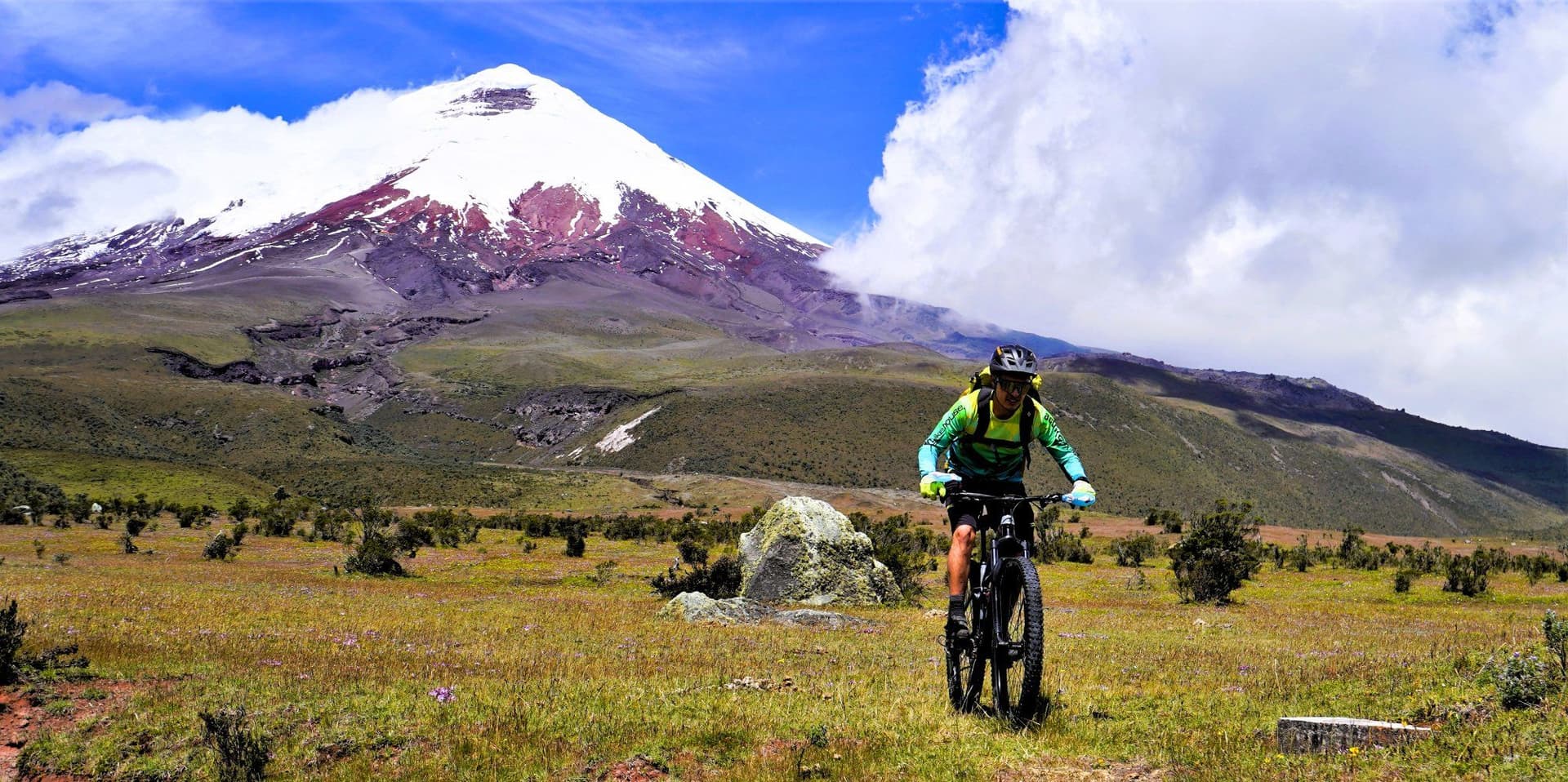
Distance 34 kms (21 mi) | Terrain Rolling high-altitude grassland | Duration 1 day | Difficulty Moderate to hard The heart of the route runs through Cotopaxi National Park, where riders cross open páramo beneath the volcano's glaciated, almost perfectly symmetrical cone. At 5,897 m (19,347 ft), Cotopaxi ranks among the highest continuously active volcanoes on the planet, and the park around it protects a landscape of wild horses, Andean foxes known locally as culpeos, white-tailed deer, and, with real luck, the Andean condor riding the same thermals a climbing cyclist is fighting against. The road surface is generally rideable dirt and packed volcanic ash, firm in dry weather and considerably harder work after rain, and the park's gates typically close by mid-afternoon, a detail worth building into any day's timing.
Distance 71 kms (44 mi) | Terrain Rolling descent through farmland | Duration 1 day | Difficulty Moderate South of the park, the route passes Pucará de Salitre, a pre-Columbian Inca fortress built with concentric stone walls on a raised outcrop, positioned to watch over trade routes running between the highlands and the Amazon basin. From there the road eases down into the agricultural plains around Lasso, historically home to some of Ecuador's oldest colonial haciendas, working estates built with walls of volcanic stone nearly 2 m (6.5 ft) thick, sturdy enough to have survived multiple major eruptions of Cotopaxi since the estates were first raised in the late seventeenth century.
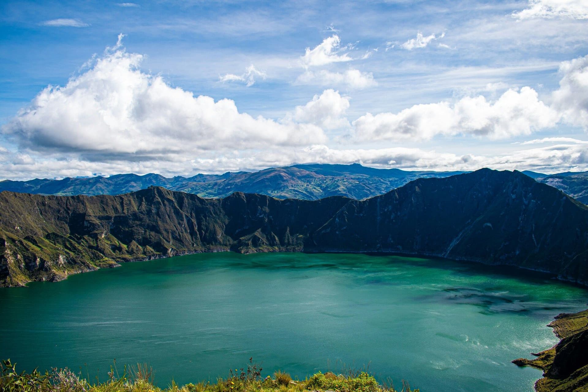
Distance 51 kms (32 mi) | Terrain Canyon rim, steady climbing | Duration 1 day | Difficulty Hard The route's final stretch traces the edge of the Toachi River Canyon, a gorge roughly 300 m (1,000 ft) deep carved through soft volcanic ash and pumice by centuries of river erosion. It climbs steadily toward the rim of Quilotoa itself, a caldera 3 kms (1.9 mi) across that collapsed in a massive eruption roughly 800 years ago. What remains today is a crater lake glowing an intense turquoise and emerald from dissolved minerals, sitting some 250 m (820 ft) below the rim trail, and few finishes anywhere in the Andes land with quite this much color waiting at the end of a hard climbing day.
Plenty of routes worth riding never make an obvious highlight reel, and cycling Ecuador is as much built around the roads locals ride every weekend as it is around the famous corridor above. The five below cover very different registers, from a smooth rail trail suited to a first day at altitude to one of the highest paved climbs on the continent.
Distance 42 kms (26 mi) | Terrain Converted rail line, mostly flat | Duration Half day | Difficulty Easy to moderate
A former rail corridor east of the capital, the Chaquiñán has become the default after-work loop for Quito's road cyclists, a smooth, largely car-free ribbon running through the Tumbaco and Puembo valleys with consistent views back toward the city's volcanic skyline. It is one of the few Ecuadorian routes genuinely suited to a first day in the country, since it lets legs adjust to altitude without demanding a mountain pass in return, and its old station buildings along the way make for easy, shaded rest stops.
Distance 115 kms (71 mi) | Terrain Long rolling descent through the central valley | Duration 1 day | Difficulty Moderate
A classic road ride running south through the central highland valley, passing small market towns and open farmland with the Avenue of Volcanoes visible for much of the way. Tradition holds that a rider earns Salcedo's famous layered ice cream, a striped, fruit-flavored treat sold from carts around the town's main square, at the finish, and that small ritual has become as much a part of the route's identity among local riders as the road itself.
Distance 45 kms (28 mi) one way | Terrain Steep, sustained high-altitude climbing | Duration 1 day | Difficulty Very hard
The road climbing Chimborazo's flank toward the first mountaineering refuge at 4,800 m (15,748 ft) is the highest paved test most touring cyclists will ever attempt, starting from the canyon town of San Juan at roughly 3,200 m (10,500 ft) and gaining altitude through increasingly thin air and increasingly frequent snow flurries near the top. The mountain also hosts Chimborazo Extremo, an annual mountain bike race billed as the country's highest competitive cycling event, and a rider who reaches the refuge under their own power earns a story that outlasts most vacation photographs.
Distance 40 kms (25 mi) between villages | Terrain Steep canyon walls, unpaved sections | Duration 1 to 2 days | Difficulty Hard
Away from the caldera itself, the wider Quilotoa Loop links a string of Quichua farming villages, including Isinlivi and Chugchilán, along ridge roads with near-constant elevation change. Community cooperatives in hamlets like Quinticusig harvest mortiño, an endemic Andean blueberry that thrives in cold páramo soil, and turn it into small-batch fruit wine, a genuinely local product with nothing in common with the export fruit grown down on the coast.
Distance 35 to 50 kms (22 to 31 mi) | Terrain Flat to rolling, warm and humid | Duration 1 day | Difficulty Easy to moderate
For a complete change of register after a week in thin mountain air, the jungle roads around Tena offer flatter grades, thicker air, and a soundtrack of birds and insects no Andean páramo can match. Routes run out toward waterfalls including Cascada Las Latas and river swimming holes, and an early start matters more here than anywhere else in the country, since heat and humidity build fast once the sun clears the canopy.
Ecuador's compact size means a rider can treat several of these bases as stops on a single loop rather than choosing only one, but each region suits a different kind of cyclist and a different stage of a trip.
Quito sits at 2,850 m (9,350 ft) in an Andean valley on the slopes of the still-active Pichincha volcano, and it earned recognition as one of the first UNESCO World Heritage cities in 1978 for its exceptionally preserved colonial core. As Ecuador's transport hub, it is where nearly every cycling trip in the country begins and ends, and it offers enough gentle riding of its own, on routes like the Chaquiñán, to prepare a rider's lungs before a harder climb further south. Suitable for riders who want easy access to bike shops, mechanics, and a full range of accommodation between rides.
South of Quito, the towns of Machachi and Lasso serve as gateways into Cotopaxi National Park and the Avenue of Volcanoes proper. Staying here puts a rider within a short transfer of some of the country's most dramatic páramo riding, and several historic haciendas in the area pair comfortable beds with direct views of the volcano itself. Suitable for riders chasing high-altitude scenery who want a proper bed rather than a wilderness camp.
Ecuador's third-largest city, Cuenca sits at a slightly gentler 2,550 m (8,370 ft) and has built one of the country's most complete networks of connected cycle paths, extensive enough that longtime riders describe local drivers as unusually accommodating toward cyclists compared with the rest of the country. The surrounding countryside offers loop rides through rural valleys and out toward Parque Nacional Cajas, a high-altitude lake district thick with native paper trees. Suitable for riders who want strong infrastructure and gentler terrain without giving up mountain scenery.
A couple of hours from Quito on the western Andean slope, Mindo has built its economy almost entirely around ecotourism and sits inside one of the richest bird habitats on the continent, with more than 500 recorded species drawing birders from around the world. For cyclists, it offers a genuine change in temperature and vegetation after the cold páramo, plus small-batch chocolate producers working with the region's native Nacional Arriba cacao. Suitable for riders who want to pair cycling with wildlife watching and a warmer, wetter climate.
North of Quito, Otavalo is best known for South America's largest indigenous textile market, held every Saturday in the town's main plaza, but the surrounding valley also offers quieter rural roads past Lago San Pablo and up toward the crater lakes of Mojanda. The region's Kichwa Otavalo community holds one of the strongest and most visible indigenous cultural identities in the country. Suitable for riders who want cultural depth and market-day energy alongside their riding.
Sitting in the shadow of the active Tungurahua volcano, Baños built its reputation on thermal springs and adventure tourism, and it serves as the natural staging point for rides east toward the Amazon-facing waterfall route locals call the Ruta de las Cascadas, passing dramatic falls including Pailón del Diablo. Suitable for riders who want one base combining hot springs recovery with access to both highland and jungle-edge terrain.
A modest jungle town roughly four hours from Quito, Tena works as the practical entry point for anyone wanting to add lowland riding to a Sierra-based trip, with a warm, humid climate that stands in total contrast to the páramo above. Suitable for riders who want to close out a high-altitude trip with a few flatter, warmer days before flying home.
Taken together, these seven bases form a rough high-to-low arc across the country, and most complete Ecuador itineraries end up threading through three or four of them rather than settling on a single fixed camp. A common pattern runs from Quito through the Cotopaxi corridor and into the Quilotoa Loop, with an optional extension west to Mindo or east toward Tena depending on how much time and altitude tolerance a group has left by the final days.
Ecuador runs on two seasons rather than four, wet and dry, and that label hides real month-by-month variation that matters for planning cycling Ecuador around clear volcano views rather than fog. The dry season runs roughly June through September, with generally drier, cooler conditions and daytime highs in the páramo around 8 to 22 degrees C (46 to 72 degrees F), the most reliable stretch for clear views of Cotopaxi, Chimborazo, and the rest of the Avenue of Volcanoes. October through January brings a second, slightly less consistent window, still generally favorable with daytime temperatures around 9 to 22 degrees C (48 to 72 degrees F) and typically good conditions for riding and photography. February tends to hold up reasonably well. March through May mark the wettest stretch, with increased cloud cover and rain that can turn unpaved sections of the Quilotoa Loop or the Chimborazo approach into genuine mud. Whatever the month, altitude changes the rules fast, since temperatures above 3,500 m (11,500 ft) drop sharply after sunset even in the driest week of August, and riders camping in the páramo should expect near-freezing nights regardless of the calendar.
Local events are worth building a trip around rather than avoiding. Ecuador's national road cycling calendar includes the Vuelta al Ecuador, a multi-stage race typically run in the second half of the year that draws professional and semi-professional teams onto many of the same roads independent tourers ride, and La Vuelta al Cotopaxi, a long-running amateur event circling the volcano that turns the park's dirt tracks into a genuine festival atmosphere for a weekend each year. Travelers hoping to watch either race, rather than dodge the road closures they bring, should time a visit accordingly.
Dive into our curated Ecuador cycling adventures today!
Few cycling destinations pack this range of wildlife into rides measured in single days rather than expedition weeks. In the páramo grasslands around Cotopaxi, cyclists share the road with wild horses descended from colonial-era stock, Andean foxes known locally as culpeos, and white-tailed deer, while overhead the Andean condor, one of the largest flying birds on Earth, occasionally rides thermals along the same ridgelines a climbing cyclist is grinding up. The high-altitude grassland itself supports frailejones in its northern reaches, a distinctive velvet-leaved plant that grows in slow, sculptural clusters and gives the páramo a genuinely alien look at dawn.
Drop off the western Andes into the Chocó cloud forest and the wildlife register changes entirely. The Tandayapa Valley and greater Mindo area hold recorded sightings of more than 500 bird species, a concentration that has made the region one of South America's premier birding destinations, headlined by dense hummingbird activity and the vivid, crimson-plumed Andean cock-of-the-rock. Orchids, bromeliads, and moss cover nearly every tree trunk in these forests, visible proof of the near-constant humidity that Pacific weather systems trap against the mountainside. The páramo also produces one distinctly edible piece of wildlife worth knowing about, mortiño, an endemic Andean blueberry harvested by small community cooperatives in villages along the Quilotoa Loop. Traditionally used in a spiced fruit dish called colada morada around the Day of the Dead in early November, mortiño has also found its way into small-batch fruit wines that make a fitting close to a hard climbing day.
Long before Von Humboldt gave the Avenue of Volcanoes its name in 1802, the corridor served as a strategic spine for the Inca empire, which built fortified outposts like Pucará de Salitre to watch over trade routes linking the highlands with the Amazon basin. Spanish colonization layered a second history on top of the Inca one, and the haciendas that still dot the Cotopaxi corridor today, some with walls of volcanic stone nearly 2 m (6.5 ft) thick, have hosted a genuine roll call of European scientific travelers, including Von Humboldt himself in 1802 and the French geodesist Charles Marie de La Condamine, who arrived decades earlier in 1742 as part of an expedition to measure the exact shape of the Earth at the equator.
That equatorial obsession never really left Ecuadorian identity. Quito sits close enough to Latitude 0 degrees that a short excursion from the city center puts a visitor standing directly on the line, and the demonstrations of equatorial phenomena on offer there, including the Coriolis effect and indigenous solar calendar knowledge that predates the Inca, tie directly into Ecuador's very name, chosen at independence specifically to mark the country's position on the equator.
Cycling culture layers on top of all this in a way that feels distinctly modern. Richard Carapaz's 2019 Giro d'Italia win, the first Grand Tour victory by any Ecuadorian rider, turned amateur group rides into genuine training-ground pilgrimages, and it remains common to find weekend pelotons attacking the same roads out of Quito that produced him. Indigenous Quichua communities across the central and southern highlands maintain their own relationship with the bicycle as well, less about racing and more about the practical business of moving people and goods between villages where a bus timetable may run only once or twice a day, a use of the bicycle that predates any imported sporting culture and continues comfortably alongside it.
Get started with your Cycling adventure now!
Ecuadorian food changes with altitude almost as dramatically as the terrain does, and a week of cycling in Ecuador tends to double as a tour through several distinct regional kitchens, from thick highland soups built for cold mornings to coastal dishes that migrated inland generations ago.
A thick, warming potato soup finished with cheese and avocado, locro de papa is the highland dish most likely to appear on a lunch menu after a cold morning on the páramo. Regional versions add corn, cheese curds, or roasted pork, but the base recipe, potato simmered until it nearly dissolves into the broth, stays consistent from Quito down to Cuenca.
Whole roasted pig, slow cooked until the skin turns to crackling and the meat falls apart on its own, hornado is the centerpiece of highland market days and Sunday family meals alike. It typically comes with llapingachos, pan-fried potato and cheese patties, and a side of mote, hominy corn that appears throughout the Sierra as a starchy counterpart to the rice found on the coast.
A tuna and yuca soup piled with pickled red onion, encebollado migrated inland from the Pacific coast and became something close to a national hangover cure, sold from street carts in nearly every highland town by mid-morning. Riders looking for a protein-heavy lunch before an afternoon climb do well to seek it out.
A hot drink built on sugarcane liquor, cinnamon, and naranjilla juice, a tart local fruit, canelazo is the standard evening warmer in any highland town once the sun drops and the temperature follows it down. It shows up at village festivals and hacienda dinners alike, usually served in a mug large enough to wrap both cold hands around.
Ecuador grows Nacional Arriba, a fine-flavor cacao variety prized internationally for its floral, almost fruity aroma, largely on small family farms around Mindo and the Chocó cloud forest rather than industrial plantations. Several bean-to-bar producers in the region walk visitors through the process from pod to finished bar, turning a rest stop into a genuine tasting.
The same endemic blueberry that colors the páramo each rainy season also ends up fermented into small-batch fruit wine by community cooperatives along the Quilotoa Loop, a genuinely local product built around an ingredient that grows nowhere else at any real scale.
Beyond the everyday market dishes, the highland calendar has its own seasonal cooking worth knowing about even for a trip that does not land on the exact date. Fanesca, a dense soup built from twelve different grains and legumes alongside salt cod, appears only in the weeks leading up to Easter and takes an entire morning of preparation, a genuinely communal dish shared among extended families rather than sold as a quick roadside snack. Guinea pig, known locally as cuy, holds a similarly deep cultural role across the rural Sierra, roasted whole over open coals for festivals and family celebrations, a food tradition that predates the Inca and remains very much alive in indigenous highland communities today.
The single biggest adjustment cycling Ecuador demands is not fitness in the usual sense but altitude tolerance. Quito already sits at 2,850 m (9,350 ft), and routes through Cotopaxi National Park and the Quilotoa Loop regularly climb past 3,500 or even 4,000 m (11,500 to 13,100 ft), elevations where the body's oxygen intake drops noticeably regardless of how many hours a rider has logged at sea level. Spending two or three easy days in Quito before attempting a serious climb gives the body time to begin producing extra red blood cells, and riders who skip this step typically find themselves gasping on gradients that would feel entirely manageable at lower altitude.
Hydration matters more here than the temperature alone suggests. The equatorial sun at high altitude carries far more ultraviolet exposure than the same air temperature would at sea level, so a cool, overcast morning on the páramo can still burn exposed skin within an hour, and dry mountain air pulls moisture from the body faster than most riders expect. Sunscreen, a proper hat under the helmet, and a hydration routine that starts before thirst sets in all matter as much as leg strength once a route climbs past 3,000 m (9,800 ft).
A hardtail or full-suspension mountain bike remains the standard choice for serious touring in Ecuador, since even paved sections carry rough patches, and unpaved links, particularly around the Quilotoa Loop and the Chimborazo approach, demand real tire clearance. Road cyclists based in Quito or Cuenca do ride the Panamericana and its quieter parallel roads on standard road bikes, but they generally stick to day rides rather than multi-day touring on backroads. E-bikes have become an increasingly common choice for visitors short on time or altitude acclimatization, since pedal assist takes real pressure off both the steep, direct climbs Ecuadorian road builders favor and the thin air at elevation, letting a rider cover more of the Avenue of Volcanoes without needing weeks to adjust first.
Quito and Cuenca both host an established network of bike shops and mechanics used to servicing serious touring and mountain bikes, a legacy of the country's competitive cycling scene and its status as a training destination for altitude-focused athletes. Community workshops and cooperative repair points also exist in smaller highland towns along the main touring routes, part of an infrastructure system built up over decades of domestic cycling culture rather than one designed purely for visitors.
Mariscal Sucre International Airport (UIO) in Quito is the main international gateway for anyone planning to cycle in the Sierra, with direct flights from major hubs across North and South America and connections through Europe. Guayaquil's airport serves the coast and offers a warmer, sea-level alternative for travelers combining cycling with beach time, though it sits well outside the Andean riding region covered in this guide.
Ecuador's intercity bus network is extensive, cheap, and generally reliable, and most operators accept bikes as checked luggage for a small additional fee, making point to point touring straightforward even without a private support vehicle. Within Quito and Cuenca, dedicated bike lane networks have expanded steadily over the past decade, though traffic on the Panamericana itself remains heavy and is best avoided in favor of quieter parallel roads wherever a route allows.
The Panamericana functions as a genuine national highway, sometimes four lanes wide and busy with freight traffic, and it is rarely an enjoyable or safe road to cycle for any real distance. Quieter secondary roads running parallel to it, along with the many rural links between highland villages, offer both safer riding and more authentic scenery, and most experienced Ecuador cyclists plan routes specifically to minimize time on the main highway.
Citizens of the United States, Canada, the United Kingdom, Australia, and most European Union countries do not need a visa for tourist stays of up to 90 days, though requirements can change and should be confirmed with official government travel advisories before departure.
Ecuador adopted the US dollar as its official currency in 2001 following an economic crisis, which makes budgeting straightforward for American travelers and generally simple for everyone else. Overnight accommodation runs from around $7 for a basic hostal room to considerably more at haciendas and eco-lodges, and a set lunch, an almuerzo including soup, a main course, and a drink, typically costs $2.50 to $3 in highland towns.
Spanish is the official language nationwide, though Kichwa remains widely spoken across indigenous highland communities and appears on road signs and market stalls throughout the Sierra. English is common in Quito's tourism-facing businesses but far less reliable in smaller highland towns, where basic Spanish goes a long way.
Mobile coverage is generally solid in towns and along the Panamericana corridor but drops out quickly on remote páramo roads and inside Cotopaxi National Park itself, so riders should download offline maps before setting out on any of the more remote sections of the Avenue of Volcanoes.
Mainland Ecuador runs on Ecuador Time (ECT), five hours behind UTC year-round, with no daylight saving adjustments to track.
Soroche, the local term for altitude sickness, affects a meaningful share of visitors who fly directly into Quito and attempt strenuous riding within the first day or two. Symptoms typically include headache, fatigue, and shortness of breath beyond what the exertion alone would explain, and the standard remedy is rest, hydration, and a slower ascent profile rather than pushing through it on the bike.
Accommodation for cyclists in Ecuador ranges from simple highland hostals charging a few dollars a night to some of the country's most historically significant haciendas. Colonial estates built in the late seventeenth century, with walls of volcanic stone thick enough to have survived multiple major eruptions, now operate as working guesthouses along the Cotopaxi corridor, pairing genuine period character with modern plumbing and direct views of the volcano that gives the region its name. Eco-lodges built in traditional Andean style, using adobe walls and thatched roofs, appear inside and around the national parks themselves, some sitting above 3,700 m (12,100 ft), high enough to double as useful acclimatization stops before an even higher climb the following day. Along the Quilotoa Loop, small mountain lodges built by and for local Quichua communities combine simple, warm rooms, often heated by wood stoves rather than electricity, with genuinely home-cooked meals sourced from the same farms visible out the window. Camping remains a viable option across much of the páramo, though several national parks, including Cotopaxi, restrict overnight stays to designated sites, and temperatures above 3,000 m (9,800 ft) drop cold enough after dark that a genuinely warm sleeping bag matters more than almost any other piece of gear on the trip.
Get started with your cycling adventure now!
Wade Davis's One River traces botanical exploration through the Andes and Amazon basin, including territory that overlaps directly with Ecuador's eastern cycling routes, and offers useful cultural and ecological context for anyone riding from the Sierra down toward Tena. General histories of Ecuador covering the La Condamine geodesic expedition and its lasting effect on the country's equatorial identity make a useful companion read for anyone curious why the nation is named for a line of latitude.
Documentary coverage of Richard Carapaz's rise from provincial junior racing to Grand Tour and Olympic victory offers a genuinely useful window into contemporary Ecuadorian cycling culture, the same culture visible in every weekend group ride climbing out of Quito.
The Vuelta al Cotopaxi, an annual amateur cycling event circling the volcano, turns the park's usually calm dirt tracks into a genuine community festival for a single weekend and is worth timing a visit around for any rider curious to see Ecuadorian cycling culture at full volume. Otavalo's Saturday market, the largest indigenous textile market in South America, rewards a rest day timed around it for anyone riding the northern Sierra. Around the Day of the Dead in early November, colada morada, a thick spiced drink built on mortiño and other Andean fruits, appears everywhere in highland towns, a seasonal ritual worth experiencing even for visitors with no family graves of their own to visit.
Everything in this guide, the páramo beneath Cotopaxi, the inhabited crater at Pululahua, the cloud forest descent into Mindo, the Inca fortress at Salitre, the colonial haciendas built to survive an eruption, and the turquoise crater lake at Quilotoa, sits within a single, carefully sequenced route that Art of Bicycle Trips runs as a guided e-bike journey through the Ecuadorian Andes. Riding with pedal assist takes real pressure off the altitude and the steep, direct climbs that define cycling in Ecuador, letting riders take in the Avenue of Volcanoes at a pace built for looking around rather than simply surviving the gradient. Whether the plan is a short highlight loop or the full corridor from Quito to the southern highlands, reach out and our team will help shape a trip around exactly this landscape, the volcanoes, the cloud forest, and the long memory the Andes hold along the way.
Dive into our curated Ecuador cycling adventures today!
Create a private trip or join a small-group departure.